|
Coastal Vulnerability Index Mapping
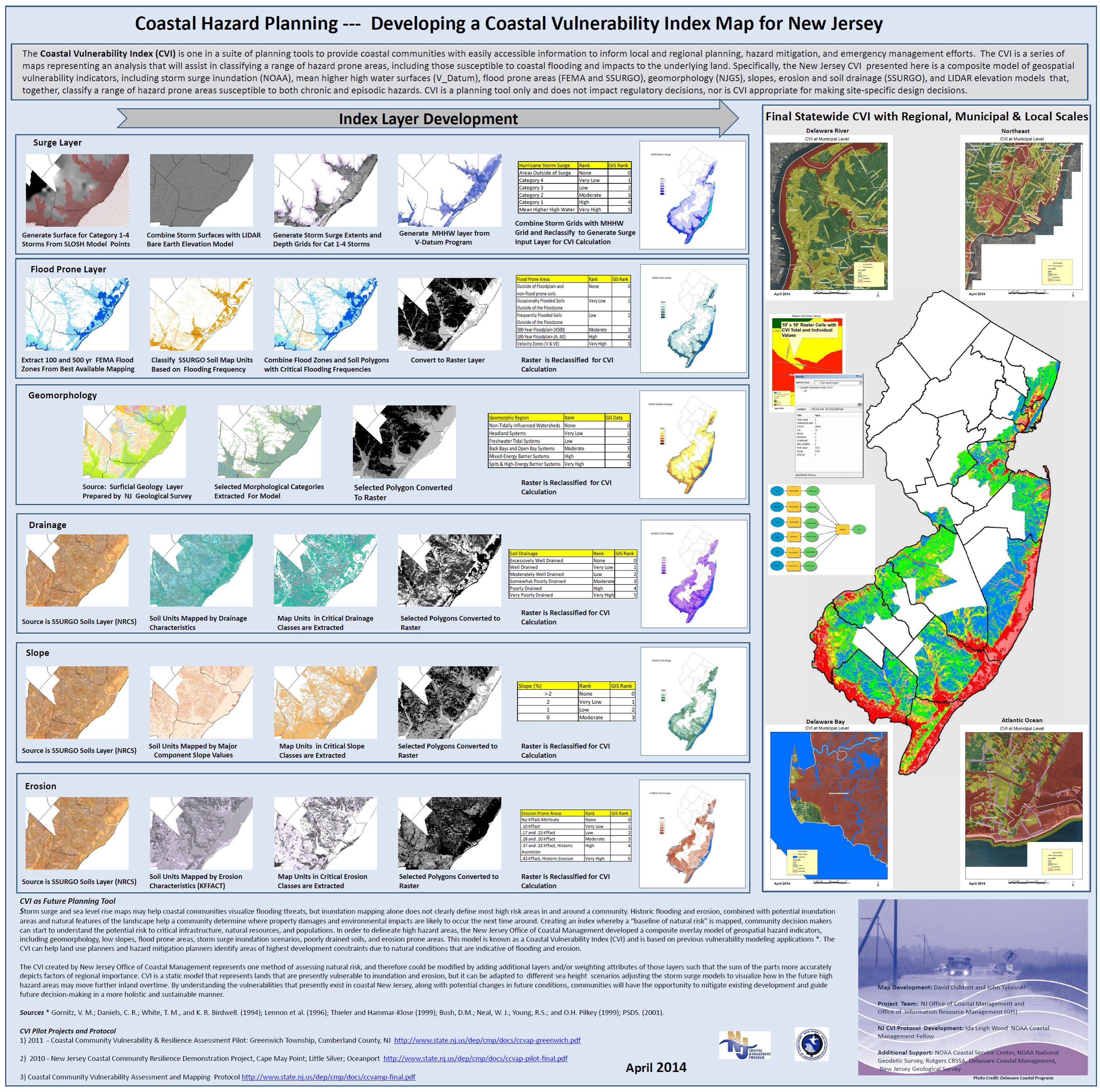
The Coastal Vulnerability Index was developed to provide community decision-makers with a “baseline of natural risk” and provide key information to begin the necessary conversations with municipal leaders about community vulnerability to coastal hazards. This data laid the groundwork for more detailed and locally-driven assessments.
The Coastal Vulnerability Index (CVI) is a composite overlay model of geospatial hazard indicators including geomorphology, slope, flood prone areas, storm surge inundation scenarios, poorly drained soils, and erosion-prone areas. CVI is a static model that represents lands that are presently vulnerable to inundation and erosion and can be adapted to different sea level scenarios. A poster illustrating the development and elements of CVI can be found at www.nj.gov/dep/gis/MappingContests/mapcon2014/maps/DI16.jpg and
www.nj.gov/dep/cmp/docs/ccvamp-final.pdf
Storm surge and sea level rise maps may help coastal communities visualize flooding threats, but inundation mapping alone does not clearly define the most high risk areas in and around a community. Combining this information with data depicting historic flooding, erosion, and natural features of the landscape, will provide a more comprehensive understanding of flooding and help a community determine what areas are vulnerable to future hazards.
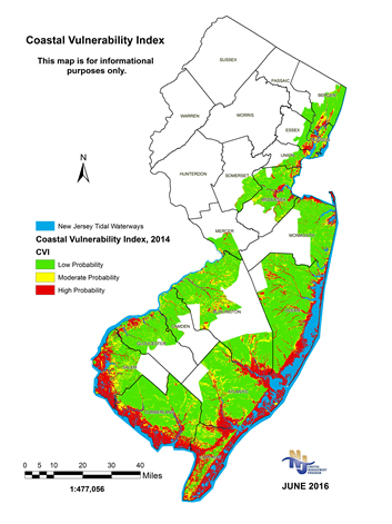
Coastal Vulnerability Index Maps
The NJCMP developed CVI mapping for the entire coastal area in New Jersey covering 239 municipalities over four sea level rise scenarios – present day (2014), 2030, 2050, and 2100. Additionally, a CVI-based map was created for each NJ coastal community. These maps can be found at www.nj.gov/dep/cmp/czm_cvi_maps.html.
Disclaimer
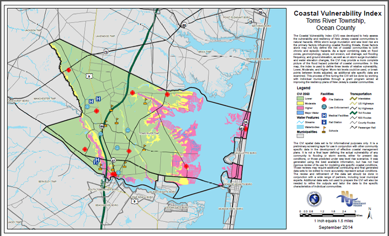
The Coastal Vulnerability Index (CVI) was developed to help assess the vulnerability and resiliency of New Jersey coastal communities to natural hazards. While storm surge inundation and sea level rise are the primary factors influencing coastal flooding threats, those factors alone may not fully define the risk of coastal communities to both chronic and episodic hazards. As a layer combining data on flood zones, geomorphology, slope, soil erosion, soil drainage, soil flooding frequency, and ground elevation, as well as on storm surge inundation and water elevation changes, the CVI may provide a more complete picture of the flood hazard risk potential of coastal communities. In this map, the index is used to define three general risk probability levels-Lower, Moderate and Higher. More risk levels could be used, or break points between levels adjusted, as additional site specific data are examined. This process of fine tuning the CVI will be done by working with individual municipalities through grant programs aimed at improving the resiliency of New Jersey’s coastal communities.
The CVI spatial data set is for informational purposes only.
It is a preliminary screening layer for use in conjunction with other community specific data in the development of effective coastal management plans. It is not a final layer defining the actual vulnerability of any community to flooding or storm events, either for present day conditions, or those predicted under sea level rise scenarios. It was generated using the best available information, but has not had rigorous review of its use for modeling site specific coastal conditions. Those reviews may require additional contributing and final generated data sets to be edited to more accurately represent actual conditions. The review and refinement of the data set should be done in conjunction with a wide range of partners, including local municipal experts. Additional data sets not used to prepare the CVI will also be needed to refine the outputs and tailor the data to the specific characteristics of individual communities.
Other Data Sources: Municipalities of New Jersey; 2008 HSIP NJ Hospitals and Fire Stations; 2009 HSIP Correctional Institutions and Law Enforcement; NJ Public, Private and Charter Schools Point Location; NJOIT Major Road Centerlines of NJ; NHD Waterbodies and Stream Network 2002.
 Contact Information Contact Information
NJDEP
NJ Office of Coastal and Land Use Planning
401-07B P.O. Box 420
401 East State Street
Trenton, NJ 08625-0420
Phone: (609) 984-0058 or (609) 633-2201
E-mail: njczm@dep.nj.gov
|
