|
|||||||||

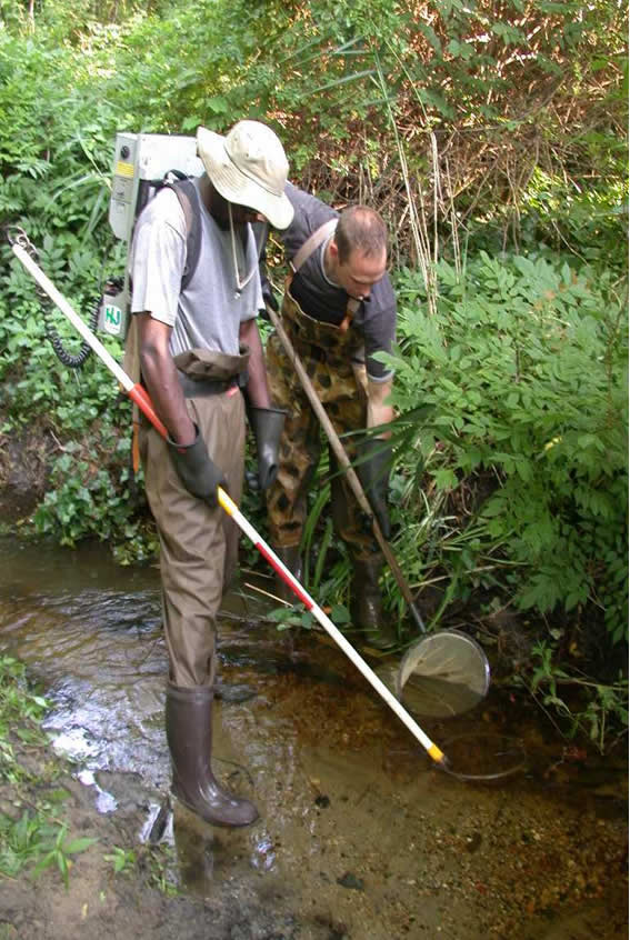
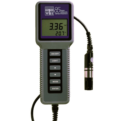
Lakes Dissolved oxygen and temperature profiles are performed during mid-August at the deepest point of a water body using a YSI Model 85 meter. For quality control purposes oxygen meters are re-verified on a monthly basis against a Winkler Titration of deionized water samples. The re-verification procedure is also repeated after any atypical field readings to verify the meter is functioning properly. Meters are field calibrated prior to each use according to the manufacturer specifications. Streams As with lakes the summer months are a critical time period for trout survival due to elevated temperatures, lower dissolved oxygen concentrations, and reduced flows. Streams are sampled from June through mid-September each year using electrofishing gear. Electrofishing provides for the safe, effective sampling of resident fishes with limited associated mortality.
The standard sampling distance, which has been used during and since the original stream surveys, is 182.9 meters (600 feet). This length was occasionally shortened when trout reproduction was found or when conditions such as an abundance of warmwater species or physical stream conditions indicated that trout would not be found. Occasionally a prospective stream or site would not be sampled based upon a visual, water temperature, or pH check that indicated conditions unsuitable for trout. Lack of water, excessive turbidity, temperatures in excess of 24°C, and extremely low pH values (4.0 or less) would result in sampling site rejection. Since 2001, in an effort to standardize data collection efforts across various research and field inventories, a distance of 150 meters was established and is used on streams when young-of-the-year trout are encountered. Since the development of the Incidence of Occurrence was based on a sampling distance of 182 meters (600 feet) this distance is still used for classifying streams when young of the year trout are not encountered. Sampling methods follow those outlined by Kurtenbach (Kurtenbach, 1994) and as defined in the U.S. Environmental Protection Agency (EPA) manual "Rapid Bioassessment Protocols for Use in Wadeable Streams and Rivers" (Barbour, 1999) and are consistent, for comparative purposes, with data collection efforts for other projects. All sites are sampled under typical stream flows during the months of June through September. Electrofishing gear is used to provide pulsed direct current to collect fishes. Settings on each of the stream units vary depending on the conductivity and flow conditions at each site; output usually ranges from 3 to 4 amperes. A typical backpack field crew consists of three persons, one to wear the backpack and netters. Stream widths exceeding the capabilities of one backpack unit are either sampled with two backpack teams traveling in tandem or with a two-paddle streamside generator. The type of unit selected is based upon stream width, depth, and contour of the stream environment. One up-stream pass is made through the sample stretch. The sample stretch length is 150 meters for streams having naturally reproducing trout populations and 182 meters (600 feet) for trout maintenance or non trout waters. Sampling time averages approximately 2.5 hours per site.
All fish encountered are collected without bias to species or size. Fishes with lengths greater than 20mm are identified to the species level, counted, and examined for disease or anomalies. Anomalies such as visible lesions, tumors, skeletal anomalies, and fin damage may be an indication of impaired conditions. Any obvious injuries due to electrofishing are noted, but not considered anomalies. Total length measurements are taken on all trout and other game species. Data is recorded on the Bureau's Supplemental Field Survey Sheet-Fish Samples (Appendix D). Retained specimens are preserved in 10% formalin solution in the field. Specimens are then transferred to a 70% ethanol solution for long-term preservation 2-3 weeks after initial collection.
In addition to fish collection, basic physical and chemical parameters of the stream environment are also measured and recorded on the Bureau's Stream Survey Data Sheet (Appendix D). All physical and chemical data are collected one-time-only, thus no long-term data is maintained. Physical parameters included stream depth, stream width, substrate type, and shade index. YSI Model 85 and YSI Model 60 meters are used to determine chemical parameters such as dissolved oxygen, temperature, salinity, conductivity, and pH. For quality control purposes oxygen meters are re-verified on a monthly basis against a Winkler Titration of deionized water samples. The re-verification procedure is also repeated after any atypical field readings to verify the meter is functioning properly. Meters are field calibrated prior to each use according to the manufacturer specifications. Alkalinity and specific conductance data have been collected since 2002. In-house laboratory staff determine alkalinity via titration. The reference temperature and temperature coefficient for specific conductance are 25° C. and 1.91% respectively. A stream habitat assessment is also conducted at each site, in accordance with criteria established by the EPA (EPA 1999). The habitat assessment is intended to evaluate various aspects of the aquatic habitat, surrounding terrestrial environment, and potential anthropogenic factors that may impact the aquatic biota of the stream. Habitat assessments have been designed for two stream types - high gradient (riffle/run prevalent) and low gradient (glide/pool prevalent) streams. High Gradient Habitat Assessments are conducted on most streams north of the Fall Line, in the Piedmont, Highlands, and Appalachian Valley and Ridge physiographic provinces. Natural high-gradient streams have substrates composed primarily of coarse sediment particles (i.e. gravel or larger) or frequent coarse particulate aggregations along stream reaches. Low-gradient habitat assessments are conducted on streams in the Coastal Plain and in other moderate to low gradient landscapes. Natural low-gradient streams have substrates of fine sediment or infrequent aggregations of more coarse (gravel of larger) sediment particles along stream reaches. Data are recorded on the bureau's Low Gradient Habitat Assessment Data Sheet and High Gradient Habitat Assessment Data Sheet (Appendix D). For the habitat assessment, ten specific physical parameters are assessed. For a low-gradient stream the parameters are: epifaunal substrate, pool substrate, pool variability, sediment deposition, channel flow status, channel alteration, channel sinuosity, bank stability, vegetative protection, and riparian vegetative zone width. The assessment for a high-gradient stream substitutes pool substrate, pool variability, and channel sinuosity with embeddedness, velocity/depth regime, and frequency of riffles or bends. The first five parameters of each assessment are assessed within the stretch of the stream electrofished. Assessments of the five remaining variables are based upon a larger stream reach that extends 150 meters upstream and downstream of the electrofished stretch. Each assessment variable is divided into four condition categories: optimal, sub-optimal, marginal, and poor, each with established criteria. Twenty points are allotted for each of the ten variables resulting in a maximum score of 200. The left and right banks of a stream, determined by facing downstream, are assessed separately for bank stability, vegetative protection, and riparian vegetative zone width. Biologists from the Bureau of Freshwater Fisheries have received habitat assessment training from EPA staff. |
|||||

|
||
|
|
||
|
||
| |
||