|
Lakes Benefit from Habitat Projects
By Chris Smith
Principal Fisheries Biologist
September, 2008
| The
Bureau of Freshwater
Fisheries completed four artificial habitat projects in 2007
and 2008 at Union Lake, Lake Lenape (Atlantic County), Hammonton
Lake, and Penbryn Lake. These projects were made possible through
partnerships with the Boy Scouts, South
Jersey Bass Club Association, Hammonton Lake Water Quality
Committee, and Atlantic
County Division of Parks and Recreation.
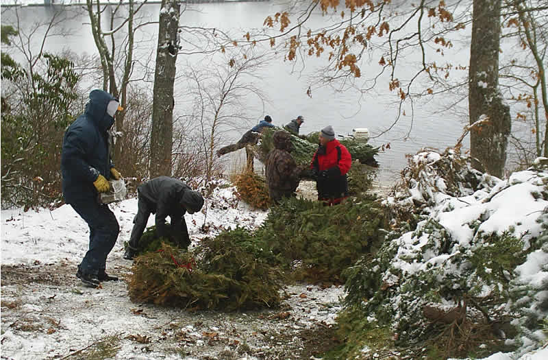
Artificial habitat projects are well documented to be effective
in increasing angler catch rates as a result of improved habitat.
The Division of Fish and Wildlife has cooperatively worked with
local-fishing organizations to enhance the habitat in many of
New Jersey's lakes, ponds, and reservoirs for years. The locations
of artificial habitats have been mapped with GPS coordinates.
|
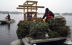
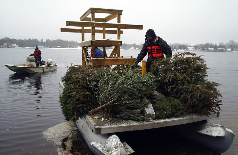
Trees
head to their destination on Lake Lenape
Click
to enlarge
|
Other projects recently completed at Assunpink Lake, Stone Tavern
Lake, and Mercer Lake (2006) were highlighted in the feature article,
"Local Lakes Get
Home Makeover."
Descriptions of the most recent projects are as follows:
LAKE LENAPE
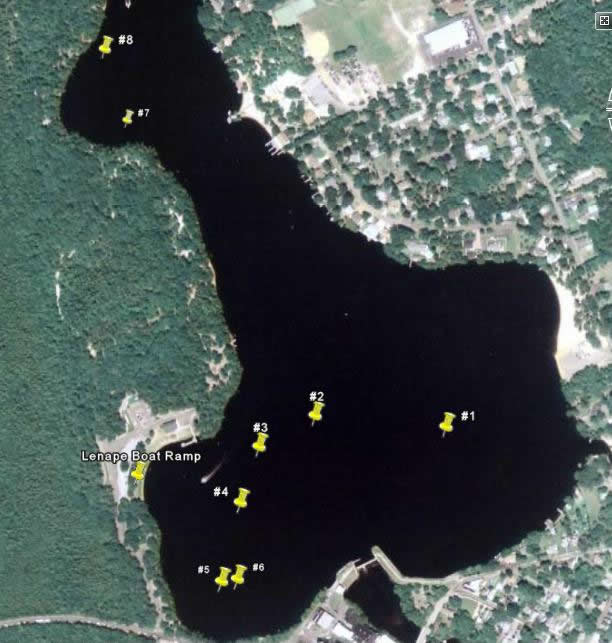
A lake habitat enhancement project was completed at Lake Lenape,
Atlantic County on February 22, 2008. A total of thirteen individuals
comprised of Atlantic County Parks staff, members of the Cedarwater
Bassmasters and Bucketmouth Brigade Bass Club, and a volunteer
from the local rowing association completed the project on a cold
winter day. Park staff and the rowing association provided boats to
deploy the habitat structures. Structures were placed in eight locations
in the deeper section of the lake near the dam, which had the least
amount of cover. A total of 300 discarded evergreen trees were dispersed
at the six locations.
|
|
| Lake Lenape |
| Site # |
Habitat Coordinates |
| 1 |
39° 27' 24.0" N |
74° 44' 01.7" W |
| 2 |
39° 27' 24.6" N |
74° 44' 10.8" W |
| 3 |
39° 27' 23.0" N |
74° 44' 14.7" W |
| 4 |
39° 27' 20.0" N |
74° 44' 16.0" W |
| 5 |
39° 27' 15.7" N |
74° 44' 17.3" W |
| 6 |
39° 27' 15.9" N |
74° 44' 16.2" W |
| 7 |
39° 27' 40.7" N |
74° 44' 23.8" W |
| 8 |
39° 27' 44.4" N |
74° 44' 25.4" W |
Map of Lake Lenape |
UNION LAKE
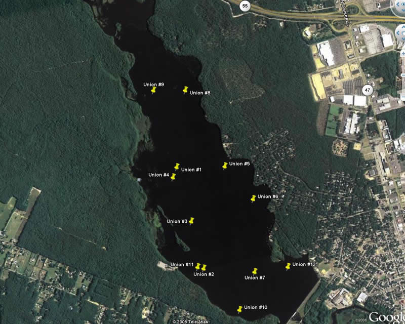
Tom Ritterhoff, a Boy Scout from Cape May Court House, NJ,
was instrumental in the Union Lake project. The structures were
deployed by fisheries biologists from the Bureau
of Freshwater Fisheries. Tom obtained all materials and
built the structures with the assistance of members from Troop
65.
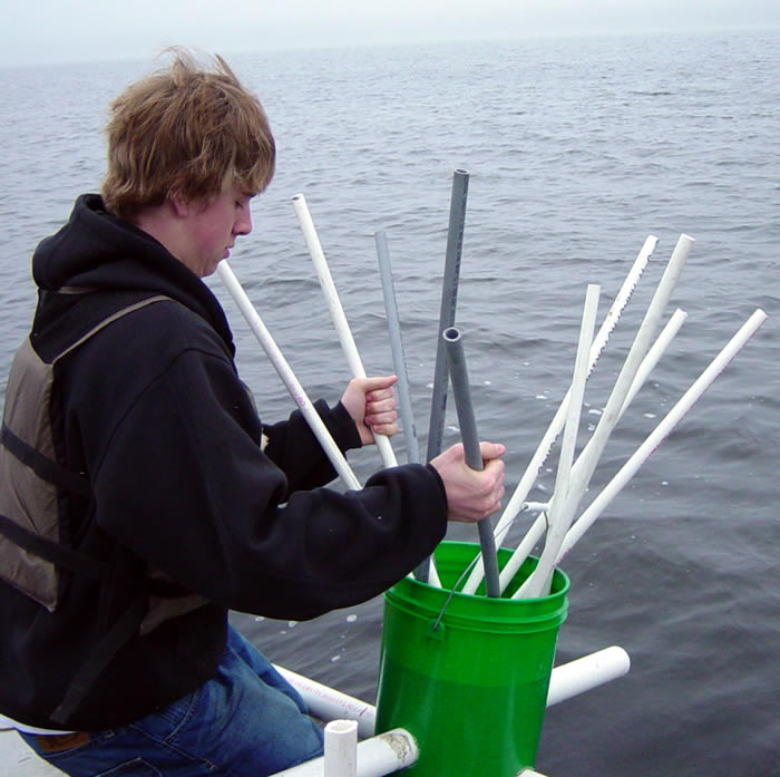
A total of 25 structures were deployed at two existing habitat
structure locations in Union Lake. The structures were constructed
from PVC pipe and plastic buckets and were placed in 10 - 12
feet of water. Warmwater fish species including largemouth and
smallmouth bass, black crappie, bluegill, and chain pickerel
will greatly benefit from this project.
| Union
Lake |
| Site # |
Habitat Coordinates |
| 1 |
39° 25' 01.9" N |
75° 03' 53.8" W |
| 2 |
39° 24' 25.5" N |
75° 03' 51.5" W |
| 3 |
39° 24' 42.4" N |
75° 3' 52.5" W |
| 4 |
39° 24' 58.7" N |
75° 3' 56.4" W |
| 5 |
39° 24' 58.7" N |
75° 3' 32.6" W |
| 6 |
39° 24' 45.5" N |
75° 3' 23.2" W |
| 7 |
39° 24' 20.6" N |
75° 3' 29.4" W |
| 8 |
39° 25' 27.4" N |
75° 3' 42.8" W |
| 9 |
39° 25' 29.7" N |
75° 3' 56.8" W |
| 10 |
39° 24' 8.8" N |
75° 3' 39.6" W |
| 11 |
39° 24' 26.4" N |
75° 3' 54.0" W |
| 12 |
39° 24' 19.9" N |
75° 3' 14.3" W |
| BOLD indicates locations of new structures |
Map
of Union Lake
|
|
HAMMONTON LAKE
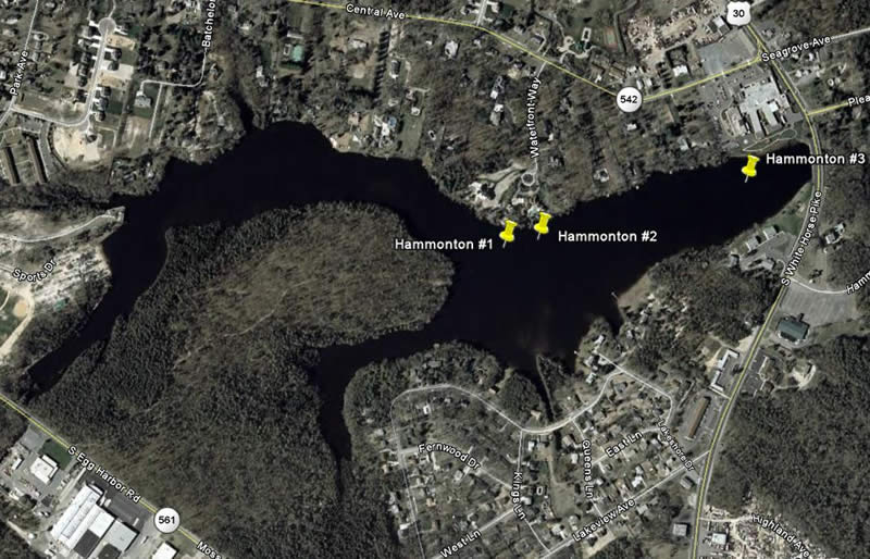
A lake habitat enhancement project was completed at Hammonton Lake,
Atlantic County on May 13, 2008. Structures were placed in three locations
in the deeper section of the lake. A total of 35 discarded evergreen
trees were dispersed at the three locations. Phase two of this project,
consisting of 30 additional structures constructed by a local fishing
organization, will be completed during the fall of 2008.
| Hammonton Lake |
| Site # |
Habitat Coordinates |
| 1 |
39° 37' 46.4" N |
74° 46' 41.8" W |
| 2 |
39° 37' 46.9" N |
74° 46' 36.0" W |
| 3 |
39° 37' 50.5" N |
74° 46' 22.0" W |
Map
of Hammonton Lake
PENBRYN LAKE
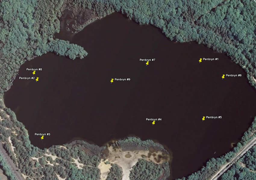
A fisheries management plan was completed in 2005 for Penbryn Lake,
and recommendations were made to deploy artificial habitat structures
to improve the largemouth bass and black crappie fisheries. The Penbryn
Lake project was completed through a partnership with Patrick Fuzer,
an Eagle Scout from Mount Laurel. The project was completed
on April 12, 2007. Eight scouts and three parents assisted with the
project. The scouts provided all materials including evergreen trees,
concrete block and rope. More than 190 trees were deployed in the
lake. Locations were predetermined utilizing a bathymetric map, GPS,
and depth finder. Structures were placed in 10 to 25 feet of water.
| Penbryn Lake |
| Site # |
Habitat Coordinates |
| 1 |
39° 45' 59.3" N |
74° 56' 16.5" W |
| 2 |
39° 45' 57.9" N |
74° 56' 32.3" W |
| 3 |
39° 45' 53.6" N |
74° 56' 31.7" W |
| 4 |
39° 45' 54.7" N |
74° 56' 21.0" W |
| 5 |
39° 45' 55.0" N |
74° 56' 16.2" W |
| 6 |
39° 45' 58.1" N |
74° 56' 14.3" W |
| 7 |
39° 45' 59.1" N |
74° 56' 21.6" W |
| 8 |
39° 45' 58.4" N |
74° 56' 32.5" W |
| 9 |
39° 45' 57.8" N |
74° 56' 25.0" W |
Map of Penbryn Lake
The staff of the Bureau of Freshwater Fisheries is continually working to improve fishing opportunities throughout the state of New Jersey and welcomes the input of independent anglers and of organized clubs.
OTHER ARTICLES by CHRIS SMITH
Local Lakes Get Home Makeover - 4/06
Break Out Your Bass Gear - Winter is Here! - 2/06
Aliens at Union Lake? - 6/05
Summertime Largemouth Bass Fishing in New Jersey is Heating Up! - 7/01
|
