| New Jersey Division of Fish and Wildlife |
|
|
June 30, 2003 Atlantic Brant Survey Team Report |
Back/Next | ||||||||||
|
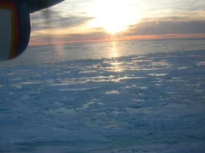
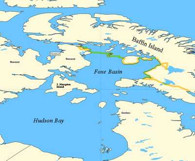
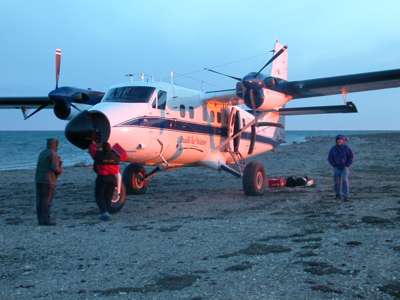
We woke early today only to find out that visibility around the Foxe Basin was still low due to dense fog and low-level cloud cover. We discussed the all the possible alternate flight routes with out pilots, but quickly realized that nowhere around the Foxe Basin would be safe to fly at the altitude we required to conduct our telemetry surveys. Our only option was to sit and hope that the weather cleared. What added to the frustration was that the weather where we were in Iqaluit was quite beautiful; the skies were clear and sunny. We met with our pilots later in the afternoon in hopes of hearing some good news about the weather. Most of the Basin was still apparently foggy, but a slight clearing to north of the Basin offered a chance to conduct some surveying along the south side of Baffin Island on our way to the Inuit community of Igloolik. We were anxious to get our surveys started so we decided to take a chance on the weather fly out later that evening. While the pilots took a few hours to ready the plane for the flight, we checked out of our lodge and got our own gear together. After much anticipation we took off from Iqaluit at 9:00 PM. This was a later start than we had hoped for, but one major benefit to surveying for wildlife north of the Arctic circle at this time of year is that there is 24-hour day light (see picture 1, taken at midnight). We were therefore not limited to the typical light-dark cycles that researchers must set their schedules to in the states. Even visual surveys could be conducted almost around the clock. Our flight plan first took us to the Great Plains of the Koukdjuak, which is located on the southwest coast of Baffin Island. We flew this area at low altitude (~ 500 feet) so that Daniel could conduct visual surveys for geese and other wildlife. Even at this low altitude Paul was able to pick up transmitter signals from four Atlantic brant. From his research here last year, and based on the location of the brant equipped with satellite transmitters, Paul had expected that some brant would be using this area for nesting. Even so, he was pleased to have located these birds and his survey was off to a productive start. In order to make it across the Foxe Basin with sufficient fuel we made a planned landing on a very short landing strip on Nikku Island. This particular landing strip is surrounded by water on three sides and is less than 1,000 feet long. As we approached, it seemed as though there would be no way for the pilots to land a plane as big as the one we were in on a landing strip as short as the one below us. Twin Otter airplanes are design for exactly this type of work, however, and our pilots safely brought the plane down with ease (see image 2). After loading the six 55-gallon drums of fuel that we had taken with us into the plane and catching a quick snack, we set off again to continue surveying. The second leg of our flight took us over the south sides of Airforce and Prince Charles Islands and allowed us to completely survey the Spicer Islands. We landed in Igloolik at 5:30 AM on July 1, 2003 having covered 1,167 miles on our first day (or night as it were) of flying (see map). We stayed in the town's co-op that morning, resting soundly for our next bout of flying. In the end, no red knots were located during this first trip and a total of 4 brant were located along the Great Plain of the Koukdjuak. Our plan was to get up in the early afternoon and continue surveying the northern part of the Foxe Basin. |
|