Facultative Vernal Pool Breeding Amphibians:
Green frog (Rana clamitans melanota)
Bullfrog (R. catesbiana)
Pickerel frog (R. palustris)
Southern leopard frog (R. utricularia)
Carpenter frog (R.virgatipes) Special Concern
Northern cricket frog (Acris crepitans)
Northern spring peeper (Psuedacris crucifer)
New Jersey chorus frog (P. triseriata kalmii)
Upland chorus frog (P. triseriata ferarium)
Northern gray treefrog (Hyla versicolor)
Southern gray treefrog (H. chrysocelis) Endangered
Pine Barrens treefrog (H. andersonii) Threatened
Four-toed salamander (Hemidactylium scutatum)
Long-tailed salamander (Eurycea l. longicauda) Threatened
American toad (Bufo americanus)
Fowler's Toad (B. fowlerii) Special Concern
In addition to amphibians, there are several reptiles that inhabit vernal pools on a seasonal basis, primarily to eat the eggs and larvae of amphibians:
Wood turtle (Glyptemys insculpta) Threatened
Spotted turtle (Clemmys guttata) Special Concern
Mud turtle (Kinosternon subrubrum)
Eastern painted turtle (Chrysemys picta picta)
Common snapping turtle (Chelydra serpentina serpentina)
(Definitions for Endangered, Threatened and Special Concern)
The Vernal Pool Survey Project
Through grants provided by the U.S. Fish and Wildlife and the DEP's Division of Science, Research and Technology, the Endangered and Nongame Species Program (ENSP) initiated the Vernal Pool Survey Project in November 2000. The main objectives of this project are to map and inventory vernal pools statewide and determine the status, range and distribution of obligate (dependent upon) vernal pool amphibians. Because staff resources are limited, the ENSP is relying primarily on trained volunteers to conduct herptile surveys at vernal pools. As data is collected on vernal pools, the information is integrated into the land use regulatory databases of the Department of Environmental Protection to implement vernal pool protection.
How Does the DEP Implement Vernal Pool Protection?
The primary way in which DEP's Land Use Regulation Program (LURP) is implementing vernal pool protection is through cross-referencing land use permit applications with mapping of certified vernal pools. When a permit is applied for, LURP staff will review maps showing all locations of certified vernal pools.
Projects proposed within or surrounding vernal pools may need to be redesigned to avoid adversely impacting them or the permit may potentially be denied. However, this protection can only be applied to vernal pools that have been previously certified. Thus vernal pool protection in New Jersey is highly dependent upon the generation of a comprehensive map of all the certified vernal pools in the state.
The other method in which DEP intends to protect vernal pools is through the Landscape Project. This statewide digital mapping, available online since fall 2001, contains critical habitat for all of New Jersey's endangered, threatened, and special concern animals. The intended purpose of this mapping is to guide sensible land use planning at the state, county and municipal level. Once mapped and inventoried, vernal pools will be incorporated as a data layer into these critical habitat maps.
Identifying Vernal Pools
The critical process of locating potential vernal pools for survey begins at the Center for Remote Sensing and Spatial Analysis (CRSSA) lab at Cook College, Rutgers University. Using a collection of computer-aided analysis techniques and field surveys, GIS analysts have been delineating potential vernal pool locations in New Jersey. The Center has compiled a number of GIS (Geographic Information Systems) abiotic data layers (including soils, wetlands, glacial sediment, and bedrock geology information) to be used in conjunction with digital elevation models and color aerial photographs to identify on-screen regions where vernal pools are likely to occur. Vernal pool likelihood is based on existing vernal pool locations. Various GIS methods have been used to identify and rank areas in each data layer based on vernal pool occurrence. This procedure, which seems to identify areas where large vernal pools are likely to occur, is followed by intensive on-screen scanning of 1-meter digital aerial photographs used to locate smaller potential vernal pool locations.
While this research is performed, an interactive Internet mapping site has been developed to enable volunteers and the public to locate potential vernal pools and introduce new volunteers to the project. The site features digital aerial photography as well as other mapping resources aimed at assisting users unfamiliar with aerial imagery. Find this exciting vernal pool information at www.dbcrssa.rutgers.edu/ims/vernal.
Vernal Pool Survey Project Update
Vernal Pool Volunteer Training Presentation - (pdf, 2.8mb)
ADDITIONAL INFORMATION

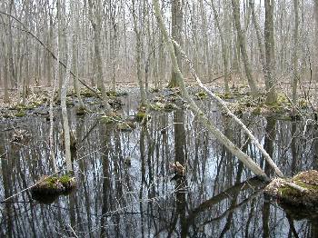 Vernal pools come in an array of forms: isolated depressions within upland forests, seasonally flooded meadows, floodplain swamps, abandoned gravel pits or quarries, and even derelict swimming pools. However, no matter what the structure or genesis of the pool is, all vernal pools either dry out completely or draw down to very shallow levels unsuitable for sustaining fish. Fish are highly predatory on amphibian eggs and larvae. Over the course of evolution, several species of salamanders and frogs exploited these fish-less water bodies. Today, these species exhibit "hard-wired" instincts and behaviors that are geared exclusively towards fish-free vernal habitats.