Digital Geodata Series
DGS00-5 ArcView 3.X Extension for Making 2D and 3D Structural Geologic Shapefiles
 
 dgs00-5.zip
(250KB) dgs00-5.zip
(250KB)
DGS00-5 includes two ArcView 3.x program extensions for creating
3-dimensional (3D) and 2-dimensional (2D) shapefiles of structural geology
symbols from tabular data files containing structural measurements, geological
variables, and geographical coordinates. These programs assist
geologists in the production of digital geological themes and maps by providing
the tools to automatically generate oriented structural symbols at any
user-specified map length. Map labels for the structural inclination
can be autolabeled using standard ArcView program options. The 3D extension
(GeoStructure3D.avx) is useful for visualizing 3-dimensional structural
relationships using the ArcView 3D analyst program extension. The
3D extension has a program dependency on the ArcView 3D Analyst extension
and provides tools for generating 2D symbols for standard map production.
The 2D version (GeoStructure2D.avx) is not dependent on the 3D Analyst
extension and provides support for map-symbol production only. The user can
choose from six 2D map symbols for planes (bedding, foliation, joint, cleavage1,
cleavage2, and half plane) or four 2D map symbols for lineations (lineation1,
lineation2, lineation3, and slip lineation). Simple rectangular polygons
are generated for 3D planar structures, and simple polylines are used for
3D lineations. Three different options are available for specifying structural
orientation (Strike, Dip, and Dip Direction; Azimuth and Inclination; and
Quadrant). Data files are added to a project as virtual tables (VTab)
prior to running the extension. VTab data are delimited text files
with a prescribed set of field names for the structural bearing and inclination,
the 'types' and 'kinds' of structures, and lithology and location variables.
VTabs also require unique point (station) identification and
geographical coordinates (x-coord and y-coord) . Shapefile output includes
variables for the station number, azmuthal bearing, inclination, units, and
location (domain).
Sample image of two 3D fracture themes generated using
GeoStructure3D.avx.
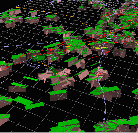
3D geological features include planes for sedimentary bedding (green),
and
joints (pink). 2D geological features include line traces of geologic contacts
(lt. purple), faults, (red), folds (orange), and a mesh (gray) with cells
measuring about 2700 ft on a side.
|