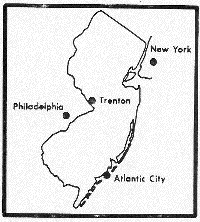
Print this worksheet, copy it and distribute it to your students as outlined in the procedure section of the lesson "Mapping the Pinelands" in the Pinelands General Information Unit.
MAPPING THE PINELANDS
Name:____________________________ Date:____________________
Directions: Use the maps provided by your teacher to answer the questions on this worksheet.

1. The 1.1 million acre N.J. Pinelands National Reserve includes (choose one):

a. just the Preservation area

b. just the Protection area

c. all of Southern New Jersey

d. only the land still covered by forests

e. both the Preservation and Protection areas.


2. Name three major cities that are within a 2 hour drive of the Pinelands.
1.___________________ 2.___________________ 3.___________________
3. In some counties, more land is Pinelands than is non-Pinelands. Which counties are mostly Pinelands? ___________________________________________________
4. Most of the Pinelands Preservation Area is in which county? ___________________
5. The Pinelands National Reserve is about the size of which state or region? _______________
6. Draw the boundaries of the Pinelands National Reserve on the map above.
7. Mark the location of your town on the map above.
8. How long would it take to drive to the Pinelands from where you live?
9. Which southern New Jersey county is not in the Pinelands National Reserve? (you will need to get an atlas that shows all of New Jersey and identifies its counties to properly answer this question)