Much of the land within the 1.1 million acre Pinelands National Reserve contains soils developed from the Cohansey geologic formation. These soils are mostly medium to coarse grained sands, although some thin clay soil layers are present. This geologic formation was deposited on the ocean floor between 13 million and 25 million years ago# during a time that geologists call the Miocene period.
The soils developed from the Cohansey formation are very porous and infertile because, for the most part, the parent material has a greater proportion of coarse sand particles than finer clay particles. The greater the proportion of coarse particles in a soil the less it is able to retain water and nutrients like calcium, magnesium, phosphorus, and potassium - "food" usually needed for plant growth. Thus, even though the Pinelands may receive the same amount of rainfall as land along the Delaware River or land In northern New Jersey, the water moves so rapidly through the sandy soil that little moisture and few nutrients are kept. The sandy soil acts more like a sieve than a sponge.
Pollutants, like large quantities of water soluble chemicals in liquid form, are able to move quickly through the sandy soil to the water table just as easily as it is for water to flow through a sieve. It is important to remember this when determining the amount of chemicals that may safely be used on both agricultural and residential land, as well as the suitability of on-site disposal of wastewater with the standard septic tank. Without careful planning, it would be easy for pollutants to reach the water table and harm the water supply.
Soils are grouped into series according to the geologic material from which they develop, as well as the makeup of their topsoil, subsoil, and horizons (or layers) that are underneath the subsoil. The Pinelands contains thirteen major soil series. Also, there are 30 additional soil series along the southern and western fringes of the region where other geologic formations are Intermixed with the Cohansey formation.
In order to simplify the understanding of Pinelands soils, this discussion will concentrate on five prevalent soil series that have developed from the Cohansey formation. These five soil series--Lakewood, Lakehurst, Atsion, Berryland, and Muck--are major factors in' the Pinelands unique soil.-water-plant-animal relationship. Each is formed under the influence of time, position (whether the soil is on a hill or in low areas with a fluctuating water table), parent material (sand or gravel), climate and biological activity.
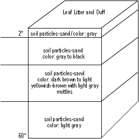
Although time, parent material, climate, and biological activity remain relatively constant for each of the five series, water table and topographic position can vary. The soils with the higher fluctuating water table tend to be situated in low level areas that have the ground water table near the surface. (There is virtually no surface runoff in the Pinelands.) Their surface colors are black underlain first by a light gray layer and then by reddish-brown and dark brown sandy layers. They may be generally categorized as wetland or bog soils.
The organic surface layer of Lakewood and Lakehurst soils decomposes slowly because there are very few microorganisms present to break it down. The decomposition that does occur produces humic acid which moves downward with percolating water. Over a long period of time, this weak acid solution removes virtually all of the materials from the surface layer. The subsurface layer becomes almost pure quartz sand. The minerals (mostly iron compounds and iron joined with organic matter that are filtered out at the top of the subsoil) and organic matter form the three to four inch dark-brown layer directly beneath the gray layer.
Bacteria that utilize the carbon for food in the Atsion and Berryland soils deplete and remove oxygen in their respiration process. As a result, the iron compounds are used as a substitute. After being used by the bacteria, the iron is said to be in a reduced state. In the reduced state, the mineral compounds are generally gray in color.
Because of the almost constant saturated condition in the muck soils, the organic matter does not completely decompose and there is a~ slow buildup through the years. Muck soils form generally in shallow pools and in low, level areas adjacent to streams.
Soil scientists feel that the underlying brown sandy layers are the result of iron compounds and fine humus particles leaching downward through the soils to the water table level in the summer. This leaching of iron compounds is part of the process by which bog iron is formed. The coarse textures and fluctuating water table found in the Atsion and Berryland soils make this process possible. Even minimal amounts of clay will prevent this process from occurring. Bog iron is often seen in stream beds and was important in the manufacture of cannon and shot used by George Washington's troops during the Revolutionary War.
Water table depth has a major effect on the sandy Pinelands soils as they develop from the parent material. The kinds of trees and shrubs that grow in different parts of the Pinelands are related to Water table depth and these five soil series. Plants that grow in the wetlands soils such as Atsion, Berryland and Muck have special adaptations that allow them to extract oxygen from the air rather than the generally saturated soil.
When settlers first came to the region during the 1600's and 1700's, they discovered most of the region's soils would not support cattle husbandry and the growing of vegetable and grain crops that were part of traditional European agriculture. For this reason, they named the region the "Pine Barrens". Since the 1800's and early 1900's, cranberries and blueberries (both requiring highly organic surface soil, a relatively high water table, and acidic conditions associated with Atsion, Berryland, and Muck soils) have been cultivated and grown on a commercial basis. Today, these crops are an important part of New Jersey's agricultural industry. When natural resources are coupled with compatible uses, the "Pine Barrens" has proven to be anything but barren.
A2 horizon: subsurface; zone of removal of nutrients, iron, and/or clay by downward moving water to lower depths of profile. Usually lighter colored then surface layer
B horizons: subsoil; acts as a filter accumulating or catching downward moving components removed from subsurface layer. Usually dark iron colored and may contain clay particles
C horizons: substratum; transition area between soil and parent material; clay layers and mineral particles may be found in this horizon; color is usually lighter than subsoil
Pineland Soil Chart
The following are some of the soils formed in Cohansey sand in a process marked by color changes
black sand; 10 inches thick
dark brown sandy layers; 7 inches thick
grayish brown sand; 13 inches thick
dark grayish-brown loamy sand; 7 inches thick
light grayish brown sand; 10 inches thick
Pitch pine, white and black oak, black gum and hickory with an understory of low bush blueberries, sheep laurel and scattered gallberry
where wildfire has been severe, there are few hardwoods except scrub oak and black jack oak
dense forest of Atlantic white cedar
In places, the growth reverts to red maple where the cedar is cut
Pitch pine, white and black oak
where wildfire has been severe-pitch pine, scrub oak & black jack oak dominate