Background Information: "The Cohansey Aquifer - Where is it? What is it?"
There are five major geomorphic provinces in New Jersey - Valley and Ridge, Highlands, Piedmont, Inner Coastal Plain, and Outer Coastal Plain. When combined, two of these - the Inner and Outer Coastal Plains - cover 60% of our state (page 280).
The 1. 1 million acre Pinelands National Reserve covers most of-the outer Coastal Plain and is underlain by the vast Cohansey Aquifer that contains 17 trillion gallons of water. This is enough water to cover the entire state to a depth of 10 feet.
Millions of years ago, melting glaciers and ocean water washed sand and gravel over the outer Coastal Plain. The forces of nature slowly created a relatively level landscape crisscrossed by winding streams and rivers such as Toms River, Oswego River, Great Egg Harbor River, Mullica River, and the Rancocas Creek. It is important to note that all Pinelands rivers rise in the Pinelands and all but one, the Rancocas Creek, flow west to east ending in the Atlantic Ocean. The Rancocas Creek, however, begins in Pemberton Township and flows west to the Delaware River.
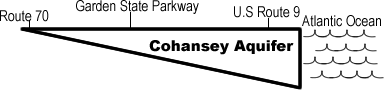
Today, the Cohansey sand formation is 2,350 square miles in size and ranges in thickness from less than 20 feet at its western edge to more than 300 feet at the Atlantic ocean. Visually, it is shaped rather like a wedge of pie that extends underground from about two miles west of Route 70 to the Atlantic Ocean.
|
|
Typically, this formation consists of fine to coarse grained sand with layers of gravel that are usually one foot thick or less. In most cases, overall clay content is less than 20 percent. Layers of white, yellow, red, and light gray clay occur generally in the upper part of the formation and may be as much as 25 feet thick. The sand is predominantly yellow, but shades of white, red, brown, and gray also occur.
Annually, about 45-inches of rain fall on New Jersey's Pinelands. It is this rain that percolates through the region's predominantly sandy soil to the groundwater stored in the Cohansey Aquifer. Excess groundwater discharges through the swamps and bogs to support 89% of the stream flow in the Pinelands.
 |
Although the Cohansey stores a large volume of water, developing it for water supply without recharge would lower the water table (the top of the Cohansey Aquifer that is generally less than 10 feet below the earth's surface). Since most of the Pinelands' unique flora (plants) and fauna (animals) are adapted to a wetlands environment, lowering the water table could disturb this entire ecosystem. In addition, New Jersey's cranberry industry, which relies on large volumes of water, would be endangered, and the frequency of fire would be increased.