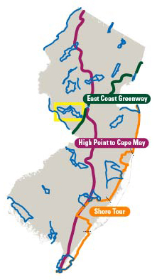
Old Mine Road Ride Greenwood Lake Campgaw Caper Allamuchy Allegory Ride Washington Rock & Roll Tour Great Swamp Ride Three Easy Scenic River Rides Three Easy Scenic River Rides Round Valley Roundabout The North Shore and More Battle of Monmouth Ride D&R Canal Towpath Ride Last Covered Bridge Ride Burlington County Bikeways Double Trouble Pine Barrens River Ramble Cumberland Salem Revolution Bayshore Byways The Cape May Shoreline Ride East Coast Greenway High Point Cape May Bike Route Three Easy Scenic River Rides A Gloucester County Country Tour Jersey City to Hoboken Waterfront Tour The Columbia Trail Explore the Jersey Shore: Cape May to Somers Point Explore the Shore: Somers Point to Tuckerton Explore the Shore: Tuckerton to Brick Explore the Shore: Brick to Sandy Hook
Last Covered Bridge Ride

Everyone loves covered bridges! And the Last Covered Bridge Ride offers three different routes that will take you by Green Sergeant’s Covered Bridge, New Jersey’s last remaining covered bridge.

Crisscrossing some of the most beautiful countryside in New Jersey, the three loops of the Last Covered Bridge Ride vary in length from 14.6 miles to 47.6 miles, taking you through picturesque Mercer and Hunterdon counties. All loops pass by the Green Sergeant’s Covered Bridge, a classic whitewashed structure that spans the rocky Wickecheoke Creek.

The routes are hilly (especially the long loop) and for the most part wind along rural roads with low traffic. These county roads offer plenty of opportunities to take in the scenery all around you. Autumn is a great time to

Last Covered Bridge Ride photo
cycle these routes, as the colorful leaves form a breathtaking mosaic.

The longest loop can begin at either Ringoes or Princeton, while the two shorter loops (14.6 miles and 24.2 miles) both begin near Ringoes.

You’ll find parking available at several areas. The East Amwell School parking lot on Wertsville Road in Ringoes is a good choice when school is not in session. Otherwise, the municipal building parking lot at Route 202 and Wertsville Road, local streets in Ringoes and Community Park North in Princeton (for the long loop) are other possibilities.

File Formats
  • KML (29k)
    Use to view tour guide routes in a mapping application on a desktop computer, mobile device or GPS device.
  • Geospatial PDF (638k)
    Use to view your current location along the tour guide routes using a GPS enabled mobile device.
  • PDF (1.2m)
    Use to view or print the tour guide routes in a brochure format.

Instructions for using these files formats is available.