Old Mine Road Ride Greenwood Lake Campgaw Caper Allamuchy Allegory Ride Washington Rock & Roll Tour Great Swamp Ride Three Easy Scenic River Rides Three Easy Scenic River Rides Round Valley Roundabout The North Shore and More Battle of Monmouth Ride D&R Canal Towpath Ride Last Covered Bridge Ride Burlington County Bikeways Double Trouble Pine Barrens River Ramble Cumberland Salem Revolution Bayshore Byways The Cape May Shoreline Ride East Coast Greenway High Point Cape May Bike Route Three Easy Scenic River Rides A Gloucester County Country Tour Jersey City to Hoboken Waterfront Tour The Columbia Trail Explore the Jersey Shore: Cape May to Somers Point Explore the Shore: Somers Point to Tuckerton Explore the Shore: Tuckerton to Brick Explore the Shore: Brick to Sandy Hook
The Cape May Shoreline Ride

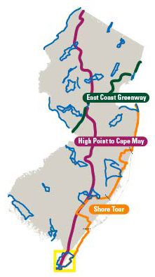
For a tour that gives the rider a generous sampling of the sites, vistas and ambience of the bayside and seaside of New Jersey’s southern-most county, head to Cape May. There are lighthouses, Victorian architecture, bays, beaches, barrier island shore communities, wetlands, the Cape May-Lewes Ferry, boardwalks and bird watching.

The terrain is flat with the highest elevation 60 feet above sea level; the ride is considered moderately easy. Windy conditions could increase the challenge level as there is little cover along the route. If this is a problem, take opportunities to short circuit and detour from this route.

Begin and end your tour at the parking lot of the Cape May Lighthouse, where the Atlantic Ocean meets the Delaware Bay at the southern tip of the Cape May Peninsula. Early in the ride, a slight detour westward along Sunset Boulevard will take you to Sunset Beach, where lucky beachcombers may find Cape May “diamonds”, translucent quartz pebbles that wash up on the beach.

The Cape May Shoreline Ride photo
Without the detour, the route heads north, crosses the Cape May Canal, then passes the entrance to the Delaware River and Bay Authority’s (DRBA) Cape May-Lewes Ferry. Riders have the option at this point to take an 80-minute ferry ride across the bay to Lewes, Delaware. Scheduling and fare information is available on their web site or call 1.800.64.FERRY.

Back in New Jersey, leave the ferry exit area and continue north along the bay side of the peninsula. About halfway up the peninsula, the route swings east toward the Atlantic Ocean, then it passes through Cape May Court House, the county seat, through Back Bay wetlands and crosses the Great Sound Inlet to Stone Harbor. A detour to Route 9 North will lead you to the Cape May County Park and Zoo.

The route turns south on a section of Ocean Drive, a series of local roads and toll bridges, free to cyclists and pedestrians, along the barrier islands that connect Cape May with Atlantic City.

Crossing the Stone Harbor Bridge and the Grassy Sound Bridge, continue on to Hereford Inlet Lighthouse, through the Wildwoods and again cross the canal before riding through Cape May City. After leaving the nation’s oldest seashore resort, a National Historic Landmark city replete with well maintained Victorian-era homes, the route ends at the starting point.

File Formats
  • KML (54k)
    Use to view tour guide routes in a mapping application on a desktop computer, mobile device or GPS device.
  • Geospatial PDF (3.5m)
    Use to view your current location along the tour guide routes using a GPS enabled mobile device.
  • PDF (1.9m)
    Use to view or print the tour guide routes in a brochure format.

Instructions for using these files formats is available.