

Assessment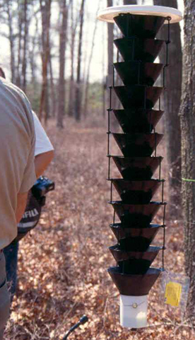
To assess outbreaks foresters:
- Deploy traps in strategic locations in the south Jersey area to detect the SPB
- Use Digital-Aerial Sketchmapping (D-ASM) in conjunction with traditional aerial photographic interpretation to map existing damage and help to predict potential spread or decline.
- Investigate areas on foot based on the aerial surveys, as well as information provided by NJ Approved Consulting Foresters and the public
SPB Traps
The NJ Forest Service monitors SPB population and distribution by setting up specialized traps in strategic locations. These traps are designed to resemble the bole of a tree. These traps are placed in forested areas where pine is not present or represents a small component of the forest type. This method reduces the chance of spreading the SPB to to areas not previously invested.
The SPB is drawn to the traps by placing a wick (white rope) into a jar filled with a turpentine attractant. A pheromone (frontalin) strip is also placed on the trap. SPB senses the turpentine and pheromone as they are dispersed by wind and follows them back to the source. The SPB then lands on the trap (above) and eventually falls down the center and into a solution that preserves them for identification. Other beetles are also trapped such as the checkered beetle which is a natural predator to the SPB.
Foresters collect, identify, and count the beetles in the traps. The SPB population can be extreme, high, moderate,
static or declining. Suppression activities would therefore have to be prescribed accordingly. By collecting and recording the number of SPB and checkered beetle, a ratio of the two can be calculated and plotted. This ratio enables the NJ Forest Service to determine how to proceed with supression. If more checkered beetles than SPB are found it could indicate biological control could be effective and no direct suppression activities are necessary. If the foresters find more SPB than checkered beetles it could mean direct suppression activities are needed.