

Aerial Survey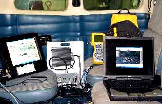
For aerial surveys, GPS equipment is linked to a laptop computer inside the plane. Geographical Information Systems (GIS) software is installed on the computer, and when linked to the GPS unit shows ground features in relation to the plane. The aerial observer or forester performing the survey maps areas showing signs of SPB damage using the touchscreen.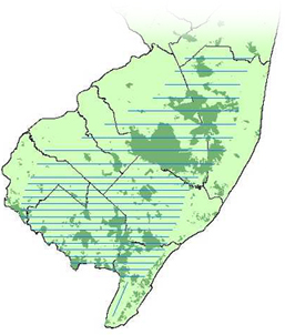
This map shows an example of flight lines over southern NJ. The shaded areas are public lands - State Parks and Forests, Natural Lands and Wildlife Mgt. Areas. The flight lines are flown east-west and west-east surveying approximately 1.3 million acres. The flight lines (blue) are 4-miles apart in the northern area and 2-miles apart in the southern area. The flight lines in the south are closer together because the majority of infestations occur in the south.