Delaware • New Jersey • Pennsylvania
New York • United States of America
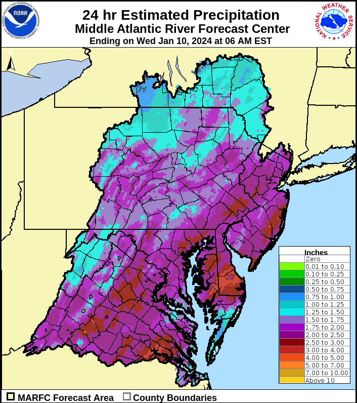
Over the past 24 hours, many locations in the Delaware River Basin have received roughly 2-3 inches of rain. Many coastal locations along the tidal Delaware River and Delaware Bay experienced significant tidal flooding, and as with any high-intensity rainfall event, flash flooding in small streams and flood-prone, low-lying and/or urban areas was also a concern. Basin rivers, creeks and streams continue to run high, with flooding occurring or forecasted at several stream gages.
Here's how much rain fell in a 24-hour period ending 6 a.m. this morning:
The DRBC has been monitoring this recent rainfall event and how it is impacting the Delaware River Basin with respect to flooding. Moderate, Minor or Action Stage flooding is currently occurring or is forecasted at several stream gages within the Basin, including those on tributaries, the non-tidal mainstem or tidal locations.
In the Basin, no Major Flooding is expected for any forecast point; however, there are several locations where it already occurred: the Neshaminy Creek at Penns Park, the East Branch Brandywine Creek below Downingtown and the following tidal locations: Washington St. in Philadelphia, Pa.; Bridesburg, Pa.; Burlington, N.J.; and Newbold Island, Pa.
Flood stage information and forecasts are from the National Weather Service's Advanced Hydrologic Prediction Service (NWS AHPS). We encourage folks to visit https://water.weather.gov/ahps/ to view up-to-date information. Most forecasts are current as of this morning and are anticipated to be updated every 6-12 hours. Please note that the DRBC does not issue flood forecasts, advisories or flood warnings.
- For the most up-to-date NWS AHPS information for the upper Delaware River Basin: https://water.weather.gov/ahps2/index.php?wfo=bgm (at this link, click the 'River Forecasts' tab to switch from observed conditions to forecasts)
- For the most up-to-date NWS AHPS information for the lower Delaware River Basin: https://water.weather.gov/ahps2/index.php?wfo=phi (at this link, click the 'River Forecasts' tab to switch from observed conditions to forecasts)
Another storm event with 1-1.5 inches of precipitation is forecasted for Friday evening into Saturday, January 12-13. The DRBC will be monitoring that event and will provide any updates as necessary.
Please Note
- The information provided herein was developed by the National Weather Service Advanced Hydrologic Prediction Service and Middle Atlantic River Forecast Center.
- This is expected to be our only update on this event. If conditions warrant, the DRBC staff will provide additional updates.
- All forecasts are subject to change, including storm track, precipitation amounts, predicted stage and crest timing. Be sure to keep up with the most current information.
- During storm events, we recommend everyone keep a close eye on real-time information from the NWS, NOAA weather radio, local TV, radio, apps – however you get your weather info.
- Please be on alert for rising water levels and follow instructions of state, county, or local emergency management, first responders, or law enforcement personnel. Note that the DRBC does not issue flood evacuations.
- Please do not travel on flooded roadways. Turn around, don't drown!
- A link to detailed NWS flood stage definitions can be found in the next section, but in brief:
- No Flooding (green) – river/stream below level where flooding becomes a concern.
- Near Flood/Action Stage (yellow) – flooding becomes a concern. River/stream is approaching or is forecast to approach the gage height – flood stage – where flooding is defined to begin. Flood stage is an established gage height for a given location at which a rise in water surface level begins to create a hazard to lives, property, or commerce.
- Minor Flooding (orange) - minimal or no property damage, but possibly some public threat.
- Moderate Flooding (red) - some inundation of structures and roads near stream. Some evacuations of people and/or transfer of property to higher elevations.
- Major Flooding (violet) - extensive inundation of structures and roads. Significant evacuations of people and/or transfer of property to higher elevations.
Useful Links
- NWS Middle Atlantic River Forecast Center: https://www.weather.gov/marfc
- NWS Mt. Holly: https://www.weather.gov/phi
- NWS Binghamton: https://www.weather.gov/bgm
- NWS Flood Stage Definitions https://www.weather.gov/aprfc/terminology
- New Jersey Office of Emergency Management (NJOEM): http://www.ready.nj.gov/
- Pennsylvania Emergency Management Agency (PEMA): https://www.pema.pa.gov/Pages/default.aspx
- Delaware Emergency Management Agency (DEMA): https://dema.delaware.gov/
- New York State Emergency Management (NYS OEM): http://www.dhses.ny.gov/oem/
- DRBC Flood Portal: https://www.nj.gov/drbc/programs/flood/portal-flood.html
- DRBC Hydrosnap Dashboard (updated daily)
- Flexible Flow Management Program (pdf)