|
|
Resiliency Initiatives: Promoting Adaptation and Risk Reduction
NJDEP
 |
DEP Blue Acres Floodplain Acquisitions
The Blue Acres program is the arm of New Jersey DEP’s Green Acres Program that purchases storm-damaged homes in flood-prone areas, and returns the land to open space. Using federal and state funds, Blue Acres purchases clusters of flood-prone homes or whole neighborhoods from willing sellers, demolishes the houses, and preserves the land permanently as open space, accessible to the public, for passive recreation or conservation. The preserved land returns floodplains to their natural function, and buffers against future storms and floods. The goal of the Blue Acres Program is to dramatically reduce the risk of future catastrophic flood damage, and to help families move out of harm’s way.
|
NJDEP Land Use Rules that require and/or encourage building standards that improve resilience of new development/re-development; examples include 1 foot additional freeboard when elevating structures, and more permissive rules governing construction of living shorelines.
|
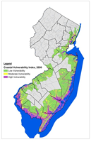
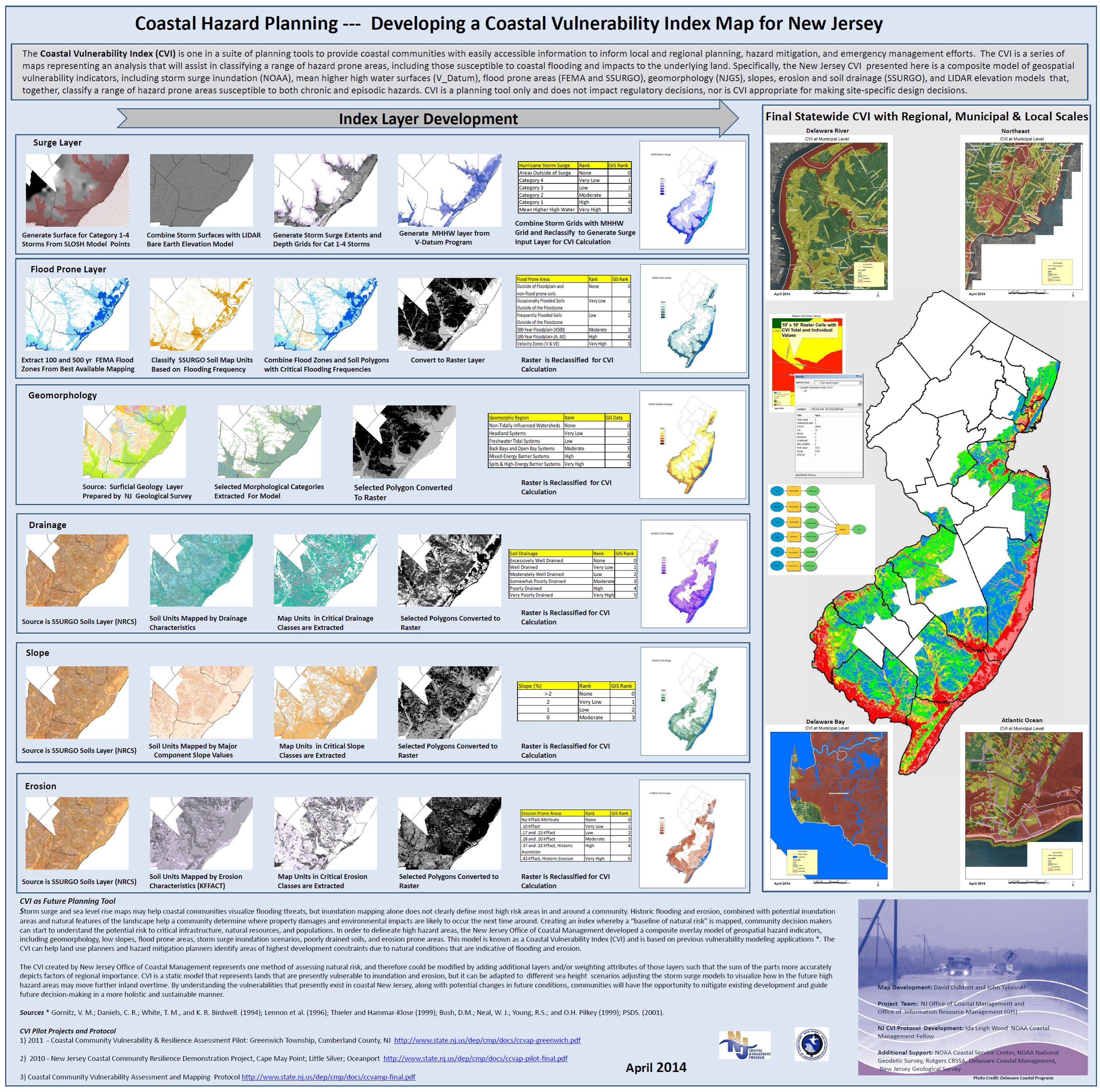
NJDEP Office of Coastal and Land Use Planning is implementing a Resilient Coastal Communities Initiative to improve the resilience of coastal towns. This initiative is providing interested coastal communities with planning, guidance, and technical support to make and implement decisions to make them more resilient to coastal hazards. The initiative is also developing and supporting the use of assessment tools, mapping, and management strategies to help guide resilience planning. As part of this effort, the Coastal Management Program (CMP) has provided 239 municipalities (NJ municipalities with tidally flowed waters or in the CAFRA area) with Coastal Vulnerability Index (CVI) mapping to begin the process of a detailed Coastal Vulnerability Assessment.
|
 |
The Resilient Coastal Communities Initiative partners the Coastal Management Program with Rutgers University, New Jersey Resiliency Network facilitated by Sustainable Jersey, Jacques Cousteau National Estuarine Research Reserve (JCNERR), NJ Future, and Monmouth University. |
The Coastal Management Program has developed a suite of tools to support community resiliency planning. This suite of tools, termed the Coastal Community Vulnerability Assessment and Mapping Protocol includes two primary tools:
 Coastal Vulnerability Index Coastal Vulnerability Index
The Coastal Vulnerability Index (CVI) is an award-winning mapping product that geospatially identifies areas vulnerable to coastal hazards. CVI is a composite overlay model of geospatial hazard indicators including storm surge, flood prone areas, geomorphology, poorly drained soils, slope, and erosion prone areas over multiple sea level rise scenarios.
More information on development of CVI can be found here.
Getting to Resilience
Getting to Resilience (GTR) is a questionnaire intended to assist local decision-makers review and characterize their existing planning, response and recovery efforts in order to identify opportunities to support community resilience. Originally developed by the Coastal Management Program, GTR was enhanced and translated into an online tool by the Jacques Cousteau National Estuarine Research Reserve. Based on the answers to the questionnaire, GTR will provide specific recommendations for municipal action for the FEMA Community Rating System and Sustainable Jersey programs.
|
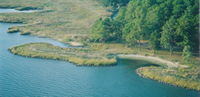 |
Living Shorelines
The Coastal Management Program also continues to lead a Department-wide effort to implement an active Living Shorelines Program. Living Shorelines is a natural bank stabilization technique that incorporates natural material and engineered structures, where appropriate, to restore lost natural shoreline. Living Shorelines also have the added benefit of protecting and maintaining valuable habitat.
The CMP is working with The Nature Conservancy and the Stevens Institute of Technology to develop a science-based program for appropriate Living Shorelines development. The CMP is also working on multiple Living Shorelines pilot projects across the state.
|
Municipal Public Access Planning
The Office of Coastal and Land Use Planning also implements the Municipal Public Access Planning program. In November 2013, the Department adopted an amendment to the Coastal Zone Management rules at NJAC 7:7E to lay out the Municipal Public Access Planning program. The MPAP program provides municipalities the opportunity to develop a community-wide plan that identifies their public access needs and desires, while still protecting the public’s right to access the shoreline.
To incent development of these plans, the Coastal Management Program has been offering small grants to municipalities to develop a MPAP. This grant program has also been supplemented to provide municipalities the option to develop a Coastal Vulnerability Assessment.
|
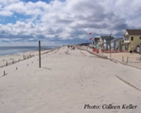 |
Beach and Dune Projects
Reinforcing the commitment to a strong and resilient shore, NJDEP has teamed up with the U.S. Army Corps of Engineers for critical beach and dune construction projects that will reduce risk to lives, properties and infrastructure by rebuilding 44 miles of New Jersey coastline and providing the state with the most comprehensive and continuous coastal protection system it has ever had. See the Map of the entire project area
Keep updated on the progress at the US Army Corp.
|
Flood Control
Beyond the coastline, the Army Corps is conducting a comprehensive study to evaluate flood-prone regions in New Jersey. Six New Jersey colleges and universities are working collaboratively to develop flood mitigation strategies for areas of the state that were heavily impacted by Superstorm Sandy and may be vulnerable to future flooding. It is expected that the analyses will help inform the Army Corps comprehensive study, among other things.
For a detailed description of the flood mitigation research to be completed in concert with state colleges and universities, please visit: http://www.nj.gov/dep/docs/flood/index.html. |
 |
| Photo by FEMA/Rosanna Arias |
|
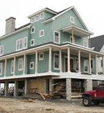
Hazard Mitigation Grant Program (HMGP) Elevation Program
In the wake of Hurricane Sandy, New Jersey implemented two major programs to repair, rebuild and elevate homes, in the nine most impacted counties, to be above the 100-year flood elevation.
The Hazard Mitigation Grant Program (HMGP) Elevations program and the Reconstruction, Rehabilitation, Elevation, and Mitigation (RREM) program were designed to assist homeowners in affected communities with the elevation of their primary single-family residences to meet the requirements for reconstruction and elevation in flood hazard areas. The State anticipates that more than 10,000 homeowners will be assisted through these programs.
For additional information about State of NJ resiliency initiatives please visit here. |
|
|
|
|
