NJ Motion Picture & Television Commission


PLEASE NOTE: The New Jersey Motion Picture & Television Commission has moved to the New Jersey Economic Development Authority. As a result, our new general email address is njfilm@njeda.gov . Similarly, the Film Ready email address is now filmreadynj@njeda.gov . All staff members can be reached using their original email addresses with the new domain ending njeda.gov. We look forward to assisting you from our new home.

About NJ

Topography

New Jersey, though one of the smaller states, has a varied topography.

In the Northwestern part a section comprising about one-fifth of the area of the state is known as the Highlands and Kitatinny Valley. This region is traversed by several low mountain ridges extending northeasterly across the state with valleys and rolling hills between. The highest of these ranges is the Kittatinny, which rises from the banks of the Delaware River at the famous Delaware Water Gap. To the east the region is studded with numerous lakes, some of the largest being Lakes Hopatcong, Mohawk and Greenwood. Elevations up to 1,800 feet above sea level are found in the Kittatinny Mountains near the New York State line.

South and East of the Highlands is a region of about equal area known as the Red Sandstone Plain, or the Piedmont of New Jersey. It is generally hilly in its northwestern part, becoming rolling and then flat toward the south and southeast. At its northern corner are the Palisades, cliffs which rise abruptly from the Hudson River to heights of 200 to 500 feet. The seacoast section extends from Sandy Hook to Cape May, a distance of about 125 miles. This area is characterized by long stretches of sandy beaches, occupied largely by summer resorts. Tidewater marshes become numerous toward the south.

In the Southern interior a region known as the Pine Barrens is covered with scrubby forest of pine and some oak. The land is low and partly swampy. Here are found the large cranberry bogs of New Jersey. In fact, most of the state that lies south of a line connecting Jersey City and Trenton is low and flat with few elevations higher than 100 feet, these being mainly in Monmouth County.

About 30 percent of the area of New Jersey drains into the Delaware River and Delaware Bay, which forms the western boundary. Nearly half of Sussex County, in the northwest, drains northward through the Wallkill River into the Hudson River. The remainder of the state drains directly into the Atlantic Ocean through the Passaic, Hackensack and Raritan Rivers in the north, and a number of small rivers and streams in the south.

Over the Southern interior the soil changes from sandy near the coast to clay and marl in the western part. However, there is no steady transition, the soil change being affected mostly by alternating stretches of the different soils and combinations of them.

In the most productive sections in the southwestern part, light-to-medium sandy loams predominate. Immense quantities of garden truck for commercial canning, especially tomatoes, are grown in Cumberland, Salem, Gloucester, Camden and western Burlington Counties.

The extreme length of the state is 166 miles and its greatest width only about 65 miles. The difference in climate is quite marked between the southern tip at Cape May and the northern extremity in the Kittatinny Mountains.

The former locality is almost surrounded by water and is fairly well removed from the influence of the frequent storms that cross the Great Lakes region and move out the St. Lawrence Valley. The northern extremity is well within the zone of influence of these storms and, in addition, lies at elevations rising from 800 to 1,800 feet. The influence of these high elevations on the temperature is considerable. The differences between these two localities are particularly marked in winter, Cape May having a normal January temperature about the same as that of southwestern Virginia, while that of Layton, in the extreme northwest, is similar to that of northern Ohio. Since the prevailing winds are mostly offshore, the ocean influence does not have full effect.

Weather

Office of the New Jersey State Climatologist
Department of Geography
Rutgers University
54 Joyce Kilmer Avenue
Piscataway, NJ 08854-8054

https://climate.rutgers.edu/stateclim/

support@climate.rutgers.edu
Phone 1: 848-445-4741
Phone 2: 848-445-3076
Fax: 732-445-0006

Climate

Temperature differences between the northern and southern parts of the state are greatest in winter and least in summer. Nearly every weather station has registered readings of 100 F or higher at some time, and all have records of zero or below.

In the northern highland area, the average date of last freeze (32 F) in spring is about May 2nd, and that of the first freeze in fall is October 12th. On the seacoast corresponding dates are April 6th and November 9th, while in the central and southern interior the dates are April 23rd and October 19th. Freeze-free days in the northern highlands average 163, with 217 along the seacoast and 179 in the central and southern interior.

Northern New Jersey is near enough to the paths of the storms which cross the Great Lakes region and down the St. Lawrence Valley to receive part of its precipitation from that source. However, the heaviest general rains are produced by coastal storms of tropical origin. The centers of these storms usually pass some distance offshore, with heaviest rainfall and strongest wind near the coast. On several occasions tropical storms have moved inland along the south Atlantic coast, and then moved northward either through or to the west of New Jersey.

Precipition

The average annual precipitation ranges from about 40 inches along the southeast coast to 51 inches in north-central parts of the state. In other sections the annual averages are mostly between 43 and 47 inches. Rainfall is well distributed during the warm months. Heavy 24-hour falls of 7 or 8 inches are occasionally recorded.

Brief periods of drought during the growing season are not uncommon, but prolonged droughts are relatively rare, occurring on the average once in 15 years. Flooding in New Jersey is usually caused by heavy general rains, at times associated with storms of tropical origin. Local flooding results from ice gorging.

The season during which measurable quantities of snow are like to fall extends from about October 15th to April 20th in the Highlands, and from about November 15th to March 15th in the vicinity of Cape May. Average seasonal amounts range from about 13 inches at Cape May to nearly 50 inches in the Highlands. Snowfalls of 10 or more inches in a single storm are occasional occurrences.

The number of days a month with measurable precipitation averages 8 for each of the fall months, September, October and November, and 9 to 12 for the other months of the year; the average yearly number is 120. Midday relative humidity averages 68 percent along the seacoast and 57 percent or less at inland locations.

Normally, sunshine varies from slightly over one-half of the possible amount in the northern counties to about 60 percent in the south. The prevailing wind is from the northwest from October to April, inclusive, and from the southwest for the other months of the year.

Tornadoes average less than one per year and most areas receive from 25 to 30 thunderstorms each year.

The invigorating climate of New Jersey, with marked changes in weather, generally neither extreme nor severe, provides an excellent setting for industrial and commercial interests, as evidences by the concentration of population in the state.

Weather Related Links
Current NJ Weather
NJ Salt Water Tide Charts - saltwatertides.com
NJ Salt Water Tide Charts - tideschart.com
Average Temperatures Chart
Average Rainfall Graph
Sunrise/Sunset Times Chart (Newark)
Sunrise/Sunset Times Chart (Atlantic City)

Mass Transportation

Airports

NEWARK INTERNATIONAL AIRPORTis the largest commercial airport in the state. Domestic flights emanate from Terminals A, B and C, international flights leave from Terminal B exclusively. The airport is accessible from the New Jersey Turnpike (Exit 13A or Exit 14) and Route 1. For more information, contact:

Newark International Airport
Newark, NJ 07112
801-401-2200

TETERBORO AIRPORT also handles commercial air traffic. For more information, contact:

Teterboro Airport
399 Industrial Avenue
Teterboro, NJ 07608
732-288-1775

ATLANTIC CITY INTERNATIONAL AIRPORT services Atlantic City and South Jersey. Airlines operating at the airport include:

Spirit Airlines, 1-800-772-7117
Delta, 1-800-221-1212

For more information, contact:
Atlantic City International Airport
Tilton Road
Pomona, NJ 08240
609-645-7895

Rail

NJ TRANSIT provides extensive rail commuter service throughout Northern New Jersey and along the Jersey shore. For more information, contact:

NJ Transit
1 Penn Plaza East
Newark, NJ 07105

Check NJ Transit Schedules on New Jersey Online
800-772-2222 (Northern NJ information)
973-762-5100 (Northern NJ information from out of state)
800-582-5946 (Southern NJ information)
215-569-3752 (Southern NJ information, from Pennsylvania)
800-582-5946 (Atlantic City information)
Northeast Corridor Line -- serves New York, Newark, New Brunswick, Princeton and Trenton
North Jersey Coast Line -- serves New York, Newark, Red Bank, Long Branch, Monmouth Park and other shore locations
Morris & Essex Lines -- serves Hoboken, Newark, Montclair, the Oranges, Bernardsville, Summit, Morristown and Dover
Atlantic City Line -- serves southern New Jersey
Raritan Valley Line -- serves Newark, Westfield, Somerville, Raritan, High Bridge
Main/Bergen Line
Pascack Valley Line
Boonton Line

AMTRAK trains travel through New Jersey along the Northeast Corridor, between New York City and Philadelphia. Rail service is also available between Philadelphia and Atlantic City. For more information about Amtrak service, call 800-USA-RAIL.

PATH service runs between Newark, Harrison, Jersey City, Hoboken and Manhattan. For more information, contact:

PATH
1 Path Plaza
Jersey City, NJ 07306
201-963-2558
1-800-234-PATH

PATCO train service runs between Philadelphia and Lindenwold, with New Jersey Transit connections to Atlantic City, Wildwood and Cape May. For more information, call 609-772-6900.

Bus

NJ TRANSIT runs extensive bus service throughout the entire state. For more information, contact:

NJ Transit
1 Penn Plaza East
Newark, NJ 07105

Check NJ Transit Schedules on New Jersey Online

800-772-2222 (Northern NJ information)
201-762-5100 (Northern NJ information from out of state))
800-582-5946 (Southern NJ information))
215-569-3752 (Southern NJ information, from Pennsylvania)

Private bus lines also run service in various areas of the state:

Academy
50 Route 26
Leonardo, NJ 07737
1-800-624-0316
(Asbury Park to Port Authority, NYC)
Amboy Coach, Inc.
P.O. Box 758
South Amboy, NJ 08879
1-732-721-1578
Boro Buses Company
445 Shrewsbury Avenue
Shrewsbury, NJ 07702
732-741-0567
C&C Carriage
Sewell, NJ
609-468-1129
Community Coach Tours
315 Howe Avenue
Passaic, NJ 07055
1-800-522-4514
Domenico Bus Service
71 New Hook Access Road
Bayonne, NJ 07002
732-339-6000
Greyhound Trailways
Penn Station
Newark, NJ 07102
973-642-8205
Middlesex Bus Lines, Inc.
15 6th Street
East Brunswick, NJ 08816
973-257-6400
Monmouth Bus Lines, Inc.
809 3rd Avenue
Asbury Park, NJ 07720
908-774-7780
Princeton Airporter
25341 East State Street
Trenton, NJ 08619
609-587-6600
Shortline
17 Franklin Turnpike
Mahwah, NJ 07430
732-529-3666
Starr Transit Company
2531 East State Street
Trenton, NJ 08619
609-587-0626

Highways And Roads

New Jersey has one of the most modern and extensive road systems in the nation, making your travel between destination points quick and convenient.

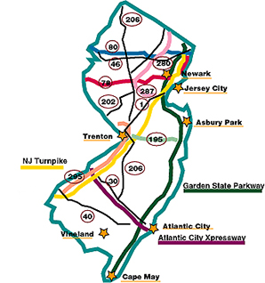
THE NEW JERSEY TURNPIKE runs northeast to southwest through the state, between the George Washington Bridge and the Delaware Memorial Bridge. It is open to commercial traffic. For more information about the Turnpike, contact:

New Jersey Turnpike Authority
Box 1121
New Brunswick, NJ 08903
908-247-0900

THE GARDEN STATE PARKWAY runs north to south through the state near its eastern border. The Parkway provides access to the New Jersey Shore and Cape May. Commercial traffic is prohibited on the Parkway north of Exit 105, although special permits can be issued. For more information about the Parkway, contact:

New Jersey Highway Authority
Woodbridge, NJ 07095
908-442-8600
908-727-5929 (traffic conditions)

THE ATLANTIC CITY EXPRESSWAY crosses southern New Jersey, providing easy access between Atlantic City and Philadelphia. It is open to commercial traffic. For more information about the Expressway, contact:

N.J. Expressway Authority
P.O. Box 351
Hammonton, NJ 08037
609-965-6060

All state highways fall under the jurisdiction of the New Jersey Department of Transportation. The D.O.T is headquartered in Trenton, although regional offices oversee specific highways.

New Jersey Department of Transportation
1035 Parkway Avenue
Trenton, NJ 08625
609-530-2000

Distance Between New Jersey Towns/Major Cities (In Miles)

Municipality New York City Philadelphia Washington, DC
Asbury Park 54 79 221
Atlantic City 112 60 202
Bridgeton 120 45 136
Burlington 79 21 159
Camden 95 3 138
Cape May 159 97 195
Clifton 13 90 240
Elizabeth 16 72 220
Flemington 55 45 166
Fort Dix 74 30 164
Freehold 47 55 201
Glassboro 106 31 135
Hackensack 10 90 239
Lakewood 61 61 204
Long Branch 50 70 228
Morristown 34 81 223
Mount Holly 75 20 156
Netcong 41 84 219
Newark 12 78 226
New Brunswick 37 55 197
Newton 50 90 234
Paterson 23 93 239
Perth Amboy 30 65 206
Phillipsburg 78 56 196
Plainfield 25 70 198
Point Pleasant 65 51 222
Princeton 46 42 181
Red Bank 45 70 231
Salem 125 35 128
Seaside Heights 72 63 189
Ship Bottom 107 65 202
Somerville 40 60 203
Sussex 50 105 250
Toms River 65 55 194
Trenton 58 29 170
Vineland 115 40 150
Woodbridge 25 70 204

Maps: Roads, Counties & Union

New Jersey Roads & Highways New Jersey Counties
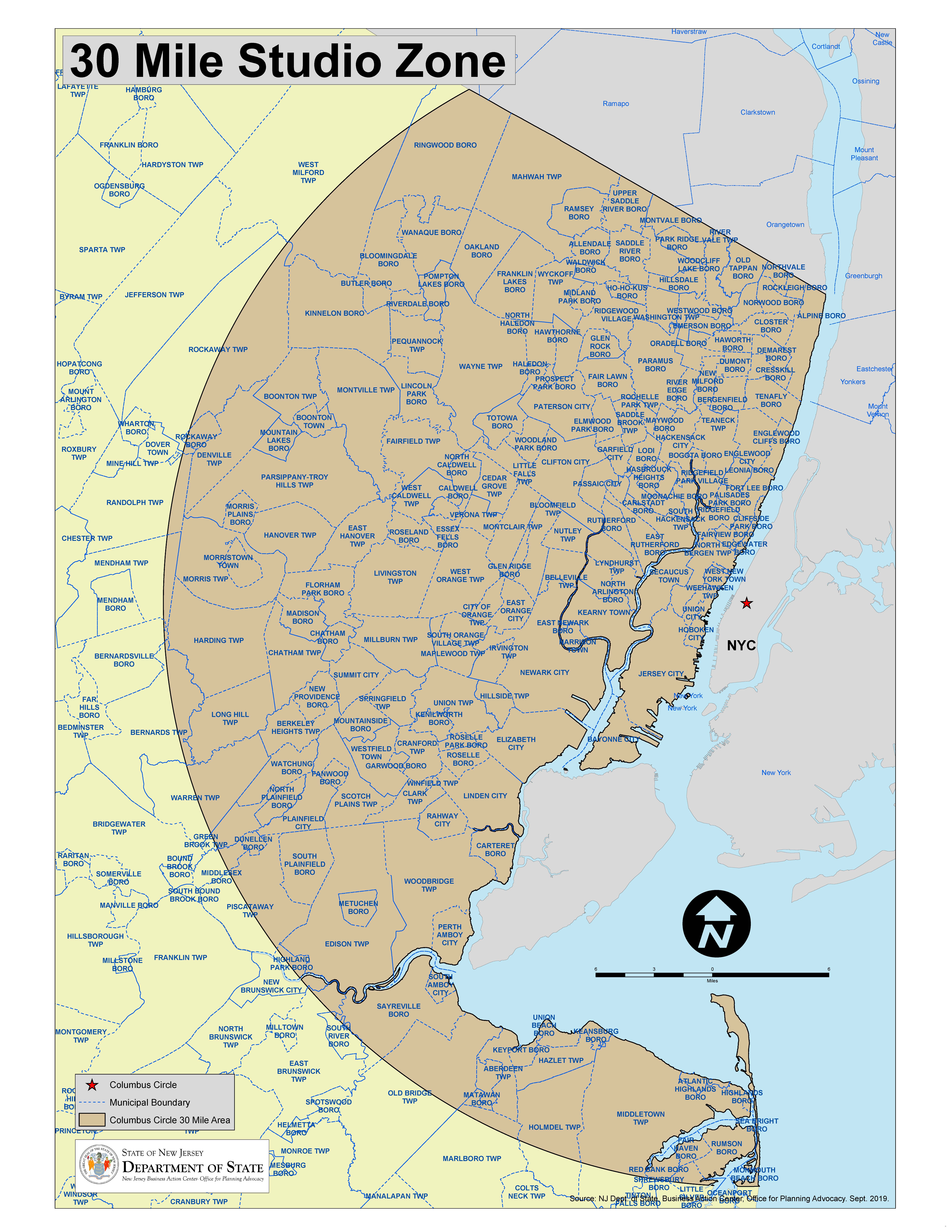
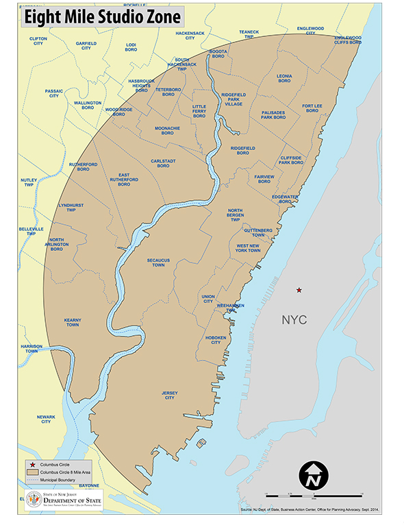
30 Mile Studio Zone Map 8 Mile SAG/AFTRA Zone Map

This map approximates the 30 mile zone from Columbus Circle, and is provided for reference purposes only. You must contact appropriate union officials in order to determine whether a particular location falls within the officially designated zone.


This map approximates the 8 mile zone from Columbus Circle, and is provided for reference purposes only. You must contact appropriate union officials in order to determine whether a particular location falls within the officially designated zone.


Back
to top