Combe Fill South Landfill September 2004 Update
Parker Road
Chester & Washington Townships, Morris County
PI #: G000004005
Superfund Site Update - September 2004
Operation & Maintenance Activities at Landfill Continuing
Ground Water Treatment Plant
The ground water treatment plant has been in operation since June 1997.
The plant treats approximately 25 million gallons of ground water per
year, which is discharged to the East Branch of the Trout Brook. Discharge
quality reports are
forwarded to the township health departments monthly.
Environmental Monitoring
NJDEP continues to monitor select wells and surface water/sediment locations
on a semi-annual basis; the remaining locations are monitored annually.
Several wells contain compounds at levels exceeding standards, with benzene
being one of the primary contaminants of concern. One surface water location
near Schoolhouse Lane has shown similar contamination.
Point of Entry Treatment (POET) Systems
NJDEP continues to maintain and monitor POET systems in 28 residences
in Chester and Washington Townships. Systems in homes along Schoolhouse
Lane are monitored semi-annually, the balance are checked annually. The
carbon units are recharged annually. The Department also samples the wells
semi-annually at the four homes on Schoolhouse Lane that do not have POET
systems. Additionally, four potable wells at “sentinel” locations
are sampled annually. Results of this periodic monitoring has remained
consistent over the last several years, typically showing exceedances
of drinking water standards in only two wells.
DEP Begins Look at Deep Ground Water Aquifer
In 1986, the remedial remedy selected included installation of an on-site
remediation system to extract and treat the contaminated ground water
in the shallow aquifer. Also required was a supplemental investigation
to evaluate the contamination in the deep ground water aquifer after initial
treatment of the shallow aquifer.
In June 2003, NJDEP engaged The Louis Berger Group to conduct the deep
aquifer remedial investigation. After reviewing the background files Berger
developed a Site Sampling and Investigation Plan (SSIP), which was submitted
to NJDEP in July.
The SSIP details five areas of investigation or Areas of Concern (AOC):
AOC 1 - on the western side of the landfill
property, bordering the neighboring property. Several monitor wells are
planned in this area.
AOC 2 - two monitor wells are planned for
this area bracketing the headwaters of the East Branch of the Trout Brook.
AOC 3 - the largest area of the investigation,
stretching from the northeastern edge of the landfill property across
Schoolhouse Lane towards Route 24. The investigation will continue up
to the tributary to the Lamington River that runs behind the homes on
the north side of the lane. The investigation in this area will involve
installing several monitor wells, sampling soil and groundwater along
Schoolhouse Lane, and sampling surface water and sediments in the tributary.
AOC 4 - will entail a more detailed ground
water investigation in the area of the fence line investigation detailed
on reverse side.
AOC 5 - represents the site-wide ground water
flow and water quality. The data collected from the previous AOCs will
be reviewed with respect to the regional conditions.
Preliminary field work with the NJ Geological Survey (NJGS) began this
spring. They are assisting NJDEP with a geophysical investigation, identifying
faults and other geological features, which will aid in citing new monitor
wells. Ongoing NJGS field work will take place this fall. Berger’s
field work is planned to commence early next year.
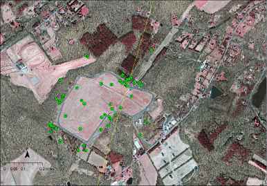
An aerial view of the Combe
Fill South Landfill with existing monitoring wells highlighted
Landfill Gases Along Perimeter of Site Tracked
In March 2001, 33 soil gas probes were installed around the perimeter
of the Combe Fill South site in order to define the extent and concentration
of landfill gases outside of the fill area and to determine any additional
areas of concern. In 2002 and 2003, 15 additional probes were installed
in areas where added information was needed. One of the main areas of
concern has been identified along the northeastern perimeter of the fill,
where the levels of landfill gases are significantly elevated (averaging
50% methane concentrations) and the fence line is quite close to the property
line. This area extends from near the power line right-of-way roughly
600' northwest along the property line. Other smaller areas with elevated
gas concentrations have been identified as well. Additional probes have
recently been installed near the treatment plant in order to determine
whether gases are migrating under the building.
Area Along Fence Line Investigated
Between December 2003 and June 2004, soil borings and test pits were
completed along the northern edge of the CFS property where waste materials
were encountered during installation of landfill gas probes. Pits were
dug along the fence line in an area approximately 450' long and 35' wide.
The investigative work revealed an area outside of the capped landfill
that contained a significant volume of pharmaceutical wastes, personal
hygiene products and drums. Fifteen drums were removed during this delineation
work; other drums were left in place. A scope of work for off-site removal
of the waste cell has been prepared and forwarded to the Responsible Parties.
They will be meeting with the Department to discuss the technical aspects
of the work.
Need More Information?
NJDEP Contact:
Mark Herzberg
Community Relations Coordinator
(609) 633-1369
mark.herzberg@dep.nj.gov
|
Related Links
|