 |
Hazsite HelpCurrent
|
|
|
|
Helpful Software for Hazsite/EDD
These resources are provided "as-is".
They may help you you in working with HazSite data
but the NJDEP makes no specific warranty for these
resources. SRP makes no representations or warranties
regarding the information provided at that Web site,
does not make a specific endorsement of the product,
and cannot assist or support the user in any way.If
you need help with the file formats, check our File
Format Help page.
CorpsCon
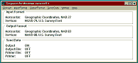 This
is a latitude-longitude to state plane feet conversion
utility program from the U.S Army Corps of Engineers.
The Corps site describes the program as a This
is a latitude-longitude to state plane feet conversion
utility program from the U.S Army Corps of Engineers.
The Corps site describes the program as a
...program which allows the user
to convert coordinates between Geographic, State
Plane and Universal Transverse (UTM) on both the
North American Datum of 1927 (NAD 27) and the North
American Datum of 1983 (NAD 83). Corpscon also performs
vertical conversions to and from the National Geodetic
Vertical Datum of 1929 (NGVD 29) and the North American
Vertical Datum of 1988 (NAVD 88).
CorpsCon for Windows is available from the U.S. Army Corps of Engineers Topographic Engineering Center (TEC) Geospatial Engineering Branch at http://www.tec.army.mil/. The current CorpsCon page on that site is at http://www.agc.army.mil/corpscon/ (As of June 20012. Subject to change without notice.)
State Plane Feet Calculator
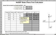 This
Microsoft Excel97 (.xls) spreadsheet is an aid for
calculating the state plane feet. Requires a spreadsheet
program that can handle Excel files. This
Microsoft Excel97 (.xls) spreadsheet is an aid for
calculating the state plane feet. Requires a spreadsheet
program that can handle Excel files.
![[Excel]](../../../images/excel.gif) Microsoft
Excel97 (21
Kb) Microsoft
Excel97 (21
Kb)
![[ZIP]](../../images/zip2.gif) Zip of MS
Excel97 file (6 Kb) Zip of MS
Excel97 file (6 Kb)
|
|
|