Delaware • New Jersey • Pennsylvania
New York • United States of America
Overview
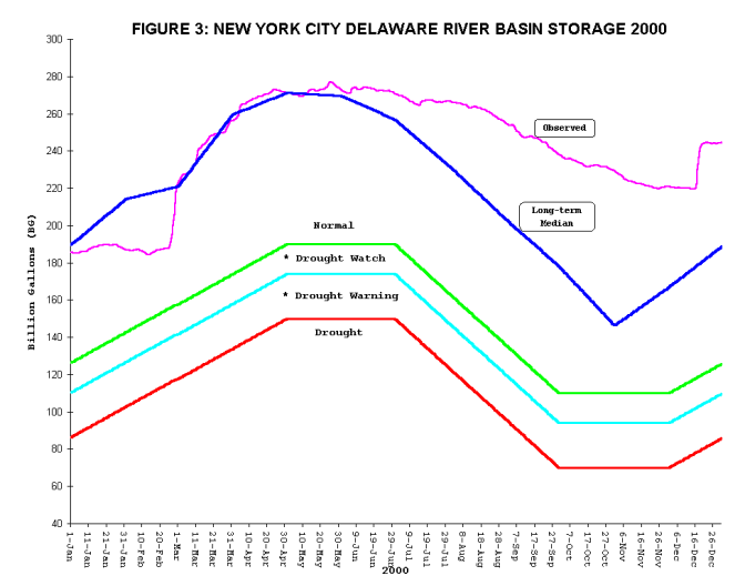
Although Hurricane Floyd's significant rainfall in September 1999 temporarily brought the lower basin back to above normal hydrologic conditions, early 2000 found New York City (NYC) reservoirs still below their normal storage levels. Upper basin water equivalent snowpack of more than 4.5 inches began to melt during the last weekend of February and NYC reservoirs rose to above normal levels in early-March. By mid-March, all of the upper basin snowpack had melted and by late-April, the NYC reservoirs had refilled to their full usable capacity of 271 billion gallons (bg).
The Delaware River Basin remained in normal hydrologic conditions throughout the late spring and summer months of 2000. Precipitation amounts continued to be above normal for the year and the abundant rainfall kept the NYC reservoirs at or close to their full capacity until July 1. Average monthly streamflows also remained above normal throughout the summer and the mid-month seven-day average of the 250 parts per million (ppm) isochlor remained below its normal location.
During late summer, a temporary revision was made to Docket D-77-20 CP to use the remaining quantity of the thermal stress bank to maintain a flow of 200 cfs on the West Branch of the Delaware at Hale Eddy, N.Y., despite river temperatures that remained below 75 degrees Fahrenheit. Good hydrologic conditions during the spring and summer required only minimum reservoir conservation releases from NYC reservoirs, resulting in greatly reduced flows along the West Branch. The thermal stress bank releases were made to supplement the low flows and were ended on October 31, 2000.
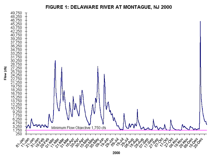
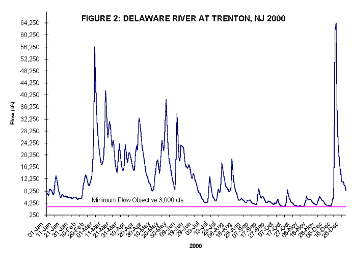
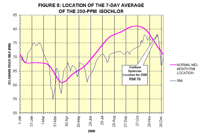
Below normal precipitation occurred during October and November. October's monthly precipitation at many stations was near record lows. Despite the lack of precipitation, storage in the NYC reservoirs remained above normal. Streamflows continued to decline into mid-December with the streamflow at Montague, N.J. at only 49 percent of normal and the streamflow at Trenton, N.J. at only 41 percent of normal. Depleted streamflows caused the seven-day average of the 250-ppm isochlor to climb to River Mile 78, four miles above its normal location for mid-December. Hydrologic conditions were eventually improved by a mid-December storm that produced rainfall amounts of up to four inches in some areas of the basin. Average daily streamflows produced by this storm for the Delaware River at Montague and the Delaware River at Trenton were at their highest since September 1999 when Hurricane Floyd battered the basin.
The year 2000 ended in normal hydrologic conditions with streamflows above normal and the NYC reservoirs at 90% capacity, over 55 bg above the median. Precipitation for 2000 was above normal for nearly all parts of the basin and the seven-day average of the 250-ppm isochlor remained at River Mile 70, four miles below its normal location for mid-December.
Precipitation
The observed precipitation above Montague for the year 2000 was 47.82 inches, or 5.23 inches above normal. Above Trenton for the year 2000, observed precipitation was 46.17 inches or 2.52 inches above normal. See the attached Table 1: Precipitation at Selected Stations in the Delaware River Basin for monthly precipitation data for select basin locations.
Streamflow
Although the year began with below normal streamflows, sufficient precipitation fell to allow streamflows to recover to near normal by February. Heavy precipitation in June resulted in well above normal streamflows for the month. Average monthly streamflows for June ranged from 186% of normal for the Schuylkill River at Philadelphia to nearly 302% of normal for the Delaware River at Montague. The Delaware River at Trenton ended the month of June at nearly 238% of normal. Dry weather in October and November caused November average monthly streamflows to drop to only 44% of normal for the Schuylkill River at Pottstown, Pa. and 38% of normal for the Lehigh River at Bethlehem, Pa. The average monthly streamflow for November at the Delaware River at Montague fell to just 57% of normal and the Delaware River at Trenton dropped to 46% of normal flow. See the attached Table 2: Streamflows in the Delaware River Basin 2000 for average monthly streamflows at selected stations and Figure 1: Delaware River at Montague, N.J., and Figure 2: Delaware River at Trenton, N.J. for year 2000 hydrographs.
Storage - Lower Basin
Beltzville and Blue Marsh Reservoirs remained at or near capacity throughout the year due to the unusually wet summer conditions. No directed releases were required from either of these reservoirs to meet the Delaware River flow objective of 3,000 cubic feet per second at Trenton.
Storage - Upper Basin
Early 2000 found NYC reservoirs still below their normal storage levels, but melting snowpack allowed the reservoirs to rise to above normal levels in early March. By the end of April, the NYC reservoirs had refilled to their full capacity of 271 billion gallons. Above average precipitation into June caused the reservoirs to spill. In fact, Neversink, Pepacton, Cannonsville, and Rondout were all spilling June 7th through 8th, 2000. The NYC reservoirs remained well above normal for the rest of the year, ending December at 244.532 bg, more than 55 bg above the daily median. Attached is a graphical presentation of NYC reservoir storage levels for 2000, Figure 3: New York City Delaware River Basin Storage 2000.
Ground Water
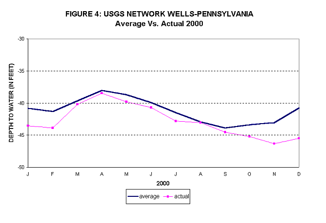
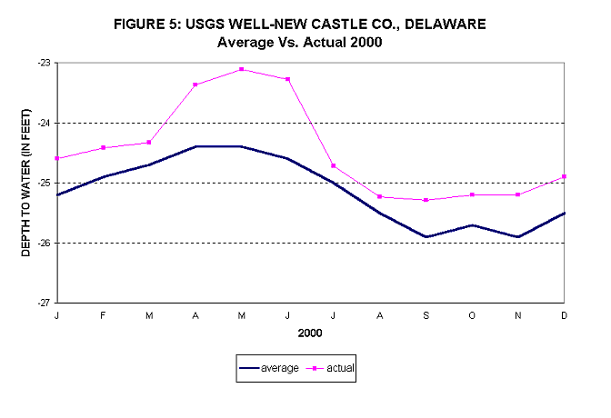
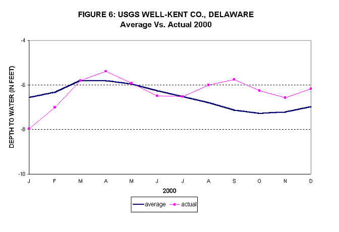
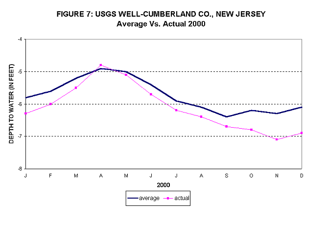
Many wells throughout the basin began the year with ground water levels lower than normal. By May, however, the average ground water levels in eight reported upland observation wells in the Pennsylvania portion of the basin rose to just below normal levels. Also by May, two observation wells in the coastal plain, one in Kent County, Del. and the other in Cumberland County, N.J., began to decline to normal and below normal levels, respectively, after rising to above normal levels in April. Another coastal plain well, located in New Castle County, Del., measured ground water levels of nearly 1.3 feet above normal by the end of May.
Throughout the summer months of 2000, ground water levels in the eight Pennsylvania observation wells trended downward, remaining slightly below the normal average by mid-September. Water levels in two of the wells in the coastal region of Delaware, one in New Castle County and the other in Kent County, were above their average levels by the end of August. Another well in the coastal plain, located in Cumberland County, continued its decline from May.
By late-December, due to below normal autumn precipitation, the average ground water levels in the eight Pennsylvania observation wells remained below normal. Water levels in two observation wells in the coastal region of Delaware, one in New Castle County, and the other in Kent County, remained above their average levels by the end of December. Another coastal plain well, in Cumberland County, N.J., registered ground water depths leveling off but remaining below average by the end of December. See the attached Figure 4: U.S. Geological Survey (USGS) Network Wells-Pennsylvania, Figure 5: USGS Well-New Castle Co., Delaware, Figure 6: USGS Well-Kent Co., Delaware, and Figure 7: USGS Well-Cumberland Co., New Jersey for an overview of ground water levels throughout the year 2000.
Chlorides
The location of the seven-day average of the 250-ppm isochlor remained relatively normal throughout 2000. Heavy rains in March caused the salt front to retreat downstream to below River Mile 55, its furthest downstream location for the year. Dry conditions in October and November allowed the salt front to advance to River Mile 78 by mid- December, its furthest upstream location for the year.
Heavy rains in mid-December caused the salt front to retreat downstream to River Mile 70 by the end of December 2000, ending the year four miles downstream of its normal mid-month location for the month. See the attached Figure 8: Location of the Seven-Day Average of the 250-PPM Isochlor for an overview of year 2000 250-ppm chloride concentration locations along the Delaware River.
Copyright © Delaware River Basin Commission,
P.O. Box 7360, West Trenton, NJ 08628-0360
Phone (609)883-9500; Fax (609)883-9522
Thanks to NJ for hosting the DRBC website