| NJ Home | | | Services A to Z | | | Departments/Agencies | | | FAQs |

|
||||||||||||
|
| ||||||||||||
|
|
The New Jersey Department of Transportation (NJDOT) began in Summer 2006 the first part of its $400 million project to replace the Route 52 Causeway bridges and the roadway section between Somers Point and Ocean City, including the elimination of the Somers Point Circle. The work is expected to last until 2013. This is one of NJDOT's largest projects and is critical because it is the emergency evacuation route for Ocean City. Two fixed and two moveable bridges will be replaced by two bridges that will have two high fixed spans over Ship Channel and Beach Thorofare (Intracoastal Waterway) and a touchdown on Rainbow Island. The new roadway section will have two 12-foot lanes and 8-foot minimum outside shoulders in each direction separated by a concrete median barrier.
July 2006 - December 2009Construction will continue on the existing north- and southbound lanes of the Route 52 bridges at Elbow and Garrets Islands and the roadway over Rainbow Island. The northbound lanes will be built first without interfering with traffic. The southbound lanes will be constructed after traffic shifts over from the existing Causeway to the newly constructed northbound lanes prior to Memorial Day 2008.
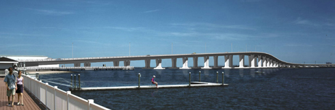 Rendering of future bridge (from Somers Point) |
||||||||
|
| department: home | about | NJ commuter | in the works | business | engineering | freight, air & water | capital | community | data | links | index | ||
| statewide: NJ Home | about NJ | business | government | state services A to Z | departments |
||
| Copyright ©
State of New Jersey, 2002-2020 Department of Transportation P.O. Box 600 Trenton, NJ 08625-0600 |
|
|
Last Updated: October 16, 2013 |
||