|
|
Community Assessments
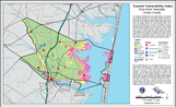 |
Coastal Vulnerability Index Maps
The NJCMP developed CVI mapping for the entire coastal area in New Jersey covering 239 municipalities over four sea level rise scenarios – present day (2014), 2030, 2050, and 2100. Additionally, a CVI-based map was created for each NJ coastal community.
CVI Maps |
|
|
 |
Getting to Resilience
This is a self-assessment tool to help municipalities identify vulnerabilities to coastal hazards. It evaluates municipal plans and policies and provides specific recommendations for the FEMA Community Rating System and for Sustainable Jersey actions.
www.PrepareYourCommunityNJ.org |
|
|
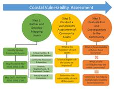 |
Coastal Vulnerability Assessment
This is a resiliency tool for determining the degree to which a community’s assets (e.g. built, natural, social) will be impacted by sea level rise and coastal flooding, and describing the consequences and risks those impacts pose to the community. The results of the CVA will help coastal communities identify and prioritize adaptation strategies, including flood mitigation, and plan strategically for long-term capital improvements. |
|
|