|
 Site Remediation News May 2001 (Vol 13 N0 1) Article 04 Site Remediation News May 2001 (Vol 13 N0 1) Article 04
Diving
Plumes: The Development and Investigation of Dissolved Contaminant Plumes
that Migrate Vertically Downward to Depths Below the Water TableBy: Jeff Griesemer, Bureau of Ground
Water Pollution Abatement A "diving plume" is described as a dissolved contaminant plume
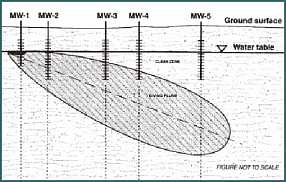
that has migrated to a depth below the water table. The vertical profile
of a diving plume includes a zone of overlying "clean" ground
water (Figure 1). Diving plumes occur at a significant number of sites due to both hydrogeological
and non-hydrogeological factors. Since the forces that induce a plume
to dive are independent of a dissolved parameter's specific gravity, vertical
migration can occur in any dissolved plume regardless of its composition.
As a result, a dissolved plume could vertically migrate if the density
of the source material is less than (e.g., LNAPL), or greater than (e.g.,
DNAPL), the density of water. The characterization of ground water conditions at most sites relies
heavily on the use of analytical data from water-table monitor wells.
However, the effectiveness of an investigation using only water-table
wells can be decreased due to vertical migration of the contaminant plume
to depths below the water table and the screened intervals of the shallow
monitor wells. As illustrated in Figure 1, the contaminant plume has migrated downgradient
of the source (MW-1) and vertically downward to a depth that is below
the screened intervals of the more distal, water-table monitor wells (MW-5).
The leading edge of the diving plume actually extends beyond the position
of a shallow well exhibiting a clean ground water sample (MW-5). Site
investigation efforts would not detect the full downgradient extent of
the diving plume and, consequently, the actual size of the plume would
be underestimated. Due to the vertical displacement of the plume, a well such as MW-4 would
be contaminated, but might under-represent actual contaminant concentrations
because of dilution. Dilution is caused by the entry of both "clean"
and contaminated ground water into a screened interval that is situated
partially above the plume. Development of A Diving Plume Both hydrogeologic and non-hydrogeologic conditions can influence the
degree to which a dissolved plume will migrate downward to a level below
the water table. A combination of these conditions usually influences
ground water and plume dynamics. These conditions include:
Downward Vertical Gradient – The most important mechanism
that causes vertical migration of a plume is the presence of a downward
vertical gradient beneath the site.
A trend of increasing hydraulic conductivity with depth could induce
a downward vertical potential beneath the site. A more permeable horizon
may be situated below, and be hydraulically connected to, the shallower
unit in which the discharge occurred. A downward hydraulic potential
would develop causing the ground water and associated contaminant plume
to migrate towards the deeper more permeable layer.
A downward vertical gradient could also be induced at recharge zones
where water is entering the aquifer.
Conversely, even though a more permeable horizon might be situated beneath
the zone of contamination, an upward hydraulic potential might be present
if the site is located within a discharge zone. For example, if a site
is located near a surface water body, ground water beneath the facility
might be discharging to the surface water (i.e., discharge zone). This
discharge would create an upward vertical gradient. This situation would
not be conducive to the development of diving plumes.
Since downward and upward vertical gradients are produced in recharge
and discharge areas respectively, it is important for investigators
to comprehend a site's subsurface hydrogeologic conditions in order
to adequately evaluate the presence of a diving plume. Precipitation Infiltration – Significant surface infiltration
of fresh water from precipitation and/or surface runoff could force
a migrating contaminant plume to "dive." Therefore, analytical
results of ground water samples obtained from water-table monitor wells
may be representative of the relatively clean infiltrated water overlying
the plume.
High rates of precipitation infiltration mainly increase the vertical
migration of plumes in recharge areas. However, precipitation rates
can be great enough to also cause vertical migration of contaminant
plumes in discharge areas. Time – If the plume is the result of an older discharge,
the contaminants would have sufficient time to migrate downward along
a vertical gradient to a level below the water table. In addition, longer
periods of time may allow infiltration of rainfall to induce significant
vertical migration.
| |
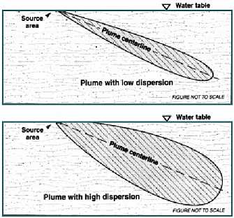
Figure 2 -
The effects of dispersion on diving plumes can be seen in the cross
section of two plumes, one with low vertical dispersion and one
with high vertical dispersion.
Figure
Adapted From Reference 1
Enlarge Image
|
Dispersion – The degree to which a compound will disperse
in ground water will affect the vertical profile of the plume. Specifically,
an aquifer with a lower vertical dispersion factor would cause a plume
to develop a relatively narrow vertical profile (Figure 2). Consequently,
the vertical height of the "clean" zone above the diving plume
would be relatively larger.
An aquifer that exhibits a high rate of vertical dispersion would cause
a diving plume to expand relatively closer to the water table. The resulting
profile would produce a narrower, less significant "clean"
zone above the plume (Figure 2). An understanding of the configuration
(e.g., thickness) of the overlying "clean" zone is an important
factor in establishing an accurate model of a diving plume's vertical
profile. Source Area – An ongoing discharge or unmitigated source
would sustain the development of a plume for a longer period of time.
Therefore, the relatively longer time period would allow the cumulative
effects of recharge, gradient and dispersion to displace the plume to
a greater vertical extent. Type of Contaminant – Each compound has unique migration
characteristics. Characteristics such as degradation and solubility
would affect the velocity and distance to which a compound will move
through the subsurface media.
For example, high biological and chemical degradation could limit plume
growth and subsequently limit vertical migration. Conversely, a recalcitrant
compound such as MTBE may persist in ground water for a longer period
of time than a readily degradable compound such as benzene. Therefore,
there would be more time for the cumulative effects of recharge, gradient,
and dispersion to vertically displace the plume.
With successful source control, persistent compounds such as MTBE might
not even be found close to the site. The MTBE may continue to move downgradient
of the site as a finite plume. The contaminants could be displaced to
deeper depths as the plume migrates further downgradient and away from
the source area.
The forces that vertically displace a plume would also have a greater
influence on plumes composed of more soluble compounds. Specifically,
more soluble compounds can be present in the aquifer at relatively higher
concentrations. Therefore, highly dissolved constituents can travel
further since their residence time in the aquifer is relatively longer.
Vertical Delineation
Factors Affecting Vertical Delineation Decisions Part of the site investigator's task is to evaluate the degree
of vertical delineation needed for a specific site. Much of this evaluation
is based on site-specific qualitative and quantitative assessments of
the hydrogeologic and non-hydrogeologic factors that promote the development
of diving plumes. The Site Remediation Program (SRP) developed a set of guidelines to
facilitate decisions regarding site- specific vertical delineation activities
("Guidance on Vertical Delineation of Ground
Water Contaminant Plumes" by Erick Kinsel, Bureau of Underground
Storage Tanks; published in this issue of the Site Remediation Newsletter).
These guidelines are partly based on a number of hydrogeological factors
that should be assessed at a site in order to determine, a) the likelihood
of a diving plume, and b) how much deeper ground water sampling is needed.
The hydrogeologic factors include:
Vertical Hydraulic Gradient – If it can be determined
from existing ground water elevation data that a downward vertical gradient
is present beneath the facility, additional vertical sampling downgradi-ent
of the source area would be needed. Additional wells (e.g., shallow
and deep well couplets) would also be warranted if the vertical gradient
cannot be determined from the existing on-site wells.
Knowledge of locally active production and municipal well operations
is important since the pumping of nearby deep wells might induce a downward
vertical gradient beneath the site. Stratigraphy – If well logs from existing wells at the
site indicate the presence of, a) a more permeable horizon below the
zone of contamination, and/ or b) an increasing trend of hydraulic conductivity
with depth, further investigation of the deeper aquifer would be warranted.
The more conductive material at depth may promote a downward vertical
component to ground water flow. A diving plume could subsequently develop
under these conditions. Conversely, a plume is less likely to dive to
a significant depth if a shallow, impervious stratigraphic unit is present
beneath the zone of contamination.
A good knowledge of site stratigraphy can greatly enhance investigation
decisions and the conceptual model of a site. -
Infiltration of Precipitation – Since the infiltration
of fresh water influences vertical migration of a plume, it is important
to assess the actual or potential degree of site-specific freshwater
infiltration activity. Factors such as, a) amount of rainfall, b) degree
of infiltration potential due to the facility's surface permeability
(e.g., impermeable macadam cap or an exposed, highly permeable sandy
soil), and c) amount of runoff should be evaluated as part of the decision-making
process.
Weaver, et.al., [1999 (2)] points out that at a
site in Long Island, an MTBE plume did not begin to dive until it reached
a distance of approximately 1000 feet downgradient of the facility.
This location coincided with the beginning of a suburban residential
area. The relatively permeable surface of the suburban zone contrasted
with the 95% paved, commercial district that was situated between the
1000 foot point and the upgradient source. Certain non-hydrogeologic factors need to be assessed since these factors
have a bearing on vertical delineation activities. For example, non-hydrogeological
factors that would affect the necessity for vertical delineation would
include, but are not necessarily limited to, a) the presence of receptors
(e.g., potable wells, surface water bodies) close to, and downgradient
of, the site, b) high contaminant levels at the source, and c) an older
release. Regarding the assessment of these factors, the "Guidance
On Vertical Delineation Of Ground Water Contaminant Plumes" includes
numeric parameters to be applied when evaluating a strategy for vertical
delineation. These assessments and observations merely suggest the likelihood of a
diving plume beneath the site. Therefore, additional sampling would be
necessary in order to, a) confirm the existence of a diving plume, and
b) delineate the plume's true lateral and vertical extent. In addition,
downgradient, off-site conditions may need to be considered since plumes
can migrate beyond site boundaries. Diving Plume Delineation Procedures The most straightforward approach for the investigation of diving plumes
is to install additional, deeper sampling points at locations along the
plume's centerline and further downgradient of the most concentrated portion
of the plume that is detected in the existing water table monitor wells.
Specifically, the additional deeper investigation should begin at points
further down-gradient of the source area and those wells exhibiting a
noticeably reduced level of contaminant concentrations. Wells with lower contaminant concentrations may represent a mixing zone
of contaminated ground water and the "clean" zone overlying
a diving plume. Therefore, deeper wells would be needed past these points
in order to target the deeper core of a diving plume. The vertical investigation would need to be continued beyond the apparent
leading edge of the plume. The plume's apparent leading edge is represented
by water-table monitor wells in which no contaminant concentrations are
detected. The additional points should be screened at depths below the
water table in order to evaluate the presence of a deeper contaminant
plume. Discrete-zone ground water sampling is necessary to adequately evaluate
the degree (angle) to which a plume is diving. The preferred method of
discrete sampling is to install nested wells with separate (i.e., not
overlapping), short-screen intervals. Screen interval placement should
target any lithologic units that are suspected of controlling vertical
migration. Alternate ground water sampling points (AGSPs) using direct-push technologies
could be used to optimize the locations and screened intervals of permanent
monitor wells. Prior to configuring the array of permanent wells, the
AGSPs would yield substantial quantities of ground water quality data
that could initially characterize, a) the centerline, and b) the top,
bottom and down-gradient boundaries of the diving plume. Optimum well
locations and construction specifications would subsequently be based
on the identified outline of the plume. Summary It is important that investigators and the regulated community be aware
that vertical plume characterization will be necessary at many contaminated
sites. This necessity is due to the consequence that an underestimation
of actual plume size might have on human health and the environment. For
example, an underestimated definition of a diving plume's lateral and
vertical extent could have a significant implication where there are deeper
potable wells situated downgradient of the contaminated site. The occurrence of a diving plume is dependent on several hydrogeologic
and non-hydrogeologic factors. The evaluation of these parameters should
be included in a site's ground water characterization plan. The evaluation
can be used to assess the potential for vertical migration of the contaminant
plume. Complete vertical delineation is necessary in order to characterize
a diving plume's true lateral and vertical extent. References Cited
University of Wisconsin-Madison, Department of
Engineering Professional Development, Underground Tank Technology Update
(UTTU). 1998. "Four Critical Considerations in Assessing Contaminated
Groundwater Plumes", UTTU, March/ April 1998, pp. 6–13. Weaver, James W., J.E. Haas, and C.B. Sosik.
1999. "Characteristics of Gasoline Releases in the Water Table
Aquifer of Long Island". Presented at the NGWA/API Conference,
1999 Petroleum Hydrocarbons Conference and Exposition, November 17-19,
Houston, Texas. General References
Fetter, C.W. Jr. 1980. "Applied Hydrogeology",
Charles E. Merrill Publishing Co. 1980, pp. 152-163. Hattan, Greg, and G. Blackburn. 1999. "Findings
of Kansas MTBE Investigations", Association of State and Territorial
Solid Waste Management Officials MTBE Workshop Newsletter, Vol. 2, No.
1, January 1999, pp. 5–8. Landmeyer, James E, F.H. Chapelle, P.M. Bradley,
J.F. Pankow, C.D. Church, and P.G. Tratnyek. 1998. "Fate of MTBE
Relative to Benzene in a Gasoline-Contaminated Aquifer (1993–98)".
Ground Water Monitoring & Remediation, Vol. 18, No. 4, Fall 1998, pp.
93–102. Robbins, Gary A. 1997. "Three-Dimensional
Sampling; A Vertical Perspective on Cleaning Up LUST Sites". L.U.S.T.
Line, Bulletin 27, November 1997, pp. 16–17. University of Wisconsin-Madison, Department of
Engineering Professional Development, Underground Tank Technology Update
(UTTU). 1999. "Diving Plume in Kansas", UTTU, Vol. 13, No.
4, July/August 1999, p. 14. University of Wisconsin-Madison, Department of
Engineering Professional Development, Underground Tank Technology Update
(UTTU). 1999. "MTBE Study at the U.S.G.S. Site in South Carolina",
UTTU, Vol. 13, No. 4, July/August 1999, pp. 9–11. Acknowledgments The following colleagues are acknowledged for their review of this article
and their constructive commentary (in alphabetical order): George Blyskun,
BGWPA; Carey Compton, BEERA; Brian Crisafulli, BGWPA; Barry Frasco, HSSE;
Tracy Grabiak, BGWPA; Erick Kinsel, BUST; Ken Kloo, EMSA; Mary Anne Kuserk,
BGWPA; Andrew Marinucci, BEERA; Jeff Story, BGWPA; Steve Urbanik, BUST. |
 |