|
New Jersey State Archives
225 West State Street-Level 2
P.O. Box 307
Trenton, NJ 08625-0307
Contact Information
Email: Feedback@sos.state.nj.us |

| Record
Group: |
Commission to
Investigate and Report upon the Abandonment of Navigation of the Morris
Canal |
| Series: |
Reports
and Photographs, 1903 |
| Accession
#: |
1979.005 |
| Series
#: |
SZMOR001 |
| Guide
Date: |
3/1992
(JK); rev. (LHB) |
| Volume: |
0.5
c.f. [1 box] |
Content
Note | Contents
Page
1: Images 1-17, Jersey City to Bloomfield
Page 2: Images 18-32, East of Paterson to Montville
Page 3: Images 33-52, East of Boonton to Wharton
Page 4: Images 53-75, Ledgewood to West
of Hackettstown
Page 5: Images 76-91, Near Port Colden to Phillipsburg
Images
18-32, East Paterson to Montville
No.
|
Caption
|
Image |
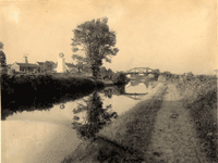
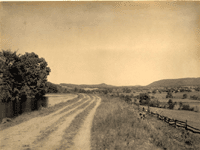
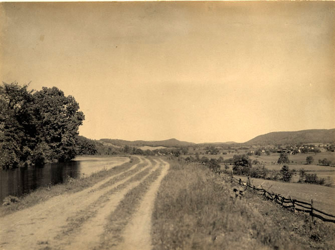
18.
|
"Near
Van Winkle's Tavern, East of Paterson." [looking north]
|
!["Near Van Winkle's Tavern, East of Paterson." [looking north]](images/szmor001/SZMOR001-018sm.gif) |
19.
|
"Near
Little Falls."
|
 |
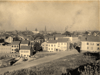
20.
|
"View
of Paterson, looking North from the Canal." |
 |
21.
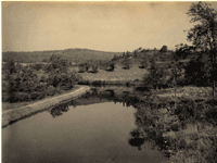
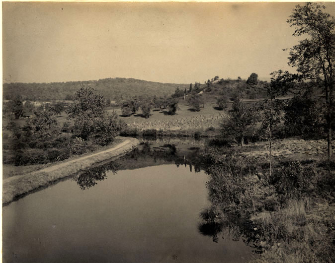
|
"Mead's
Basin west of Little Falls." [Mountain View; may be the Pompton
River, looking south toward the Pompton Aqueduct]
|
!["Mead's Basin west of Little Falls." [Mountain View; may be the Pompton River, looking south toward the Pompton Aqueduct]](images/szmor001/SZMOR001-021sm.gif) |
22.
|
"Canal
at Little Falls."
|
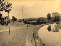 |
23.
|
"East
of Pompton Iron Works, Little Falls in the distance."
|
 |
24.
|
"Canal,
showing Pompton Feeder, near Mountain View." [looking north
up the Pompton Feeder from the main line of the canal; the bridge
is the towpath bridge over the mouth of the feeder]
|
!["Canal, showing Pompton Feeder, near Mountain View." [looking north up the Pompton Feeder from the main line of the canal; the bridge is the towpath bridge over the mouth of the feeder]](images/szmor001/SZMOR001-024sm.gif) |
25.
|
"Canal
at Pompton Feeder Junction." [looking west on the main canal;
New York and Greenwood Lake Railroad]
|
!["Canal at Pompton Feeder Junction." [looking west on the main canal; New York and Greenwood Lake Railroad]](images/szmor001/SZMOR001-025sm.gif) |
26.
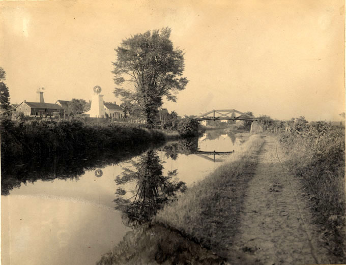
|
"The
Canal crossing the Pequannock River." [actually the Pompton
River, looking north]
|
!["The Canal crossing the Pequannock River." [actually the Pompton River, looking north]](images/szmor001/SZMOR001-026sm.gif) |
27.
|
"Canal
at Whitehall." [Montville]
|
!["Canal at Whitehall." [Montville]](images/szmor001/SZMOR001-027sm.gif) |
28.
|
"Beavertown."
[Lincoln Park; looking south toward Lower Montville, not Beavertown;
plane house for Plane 9 East can be seen in left background]
|
!["Beavertown." [Lincoln Park; looking south toward Lower Montville, not Beavertown; plane house for Plane 9 East can be seen in left background]](images/szmor001/SZMOR001-028sm.gif) |
29.
|
"View
of Canal at Montville."
|
 |
30.
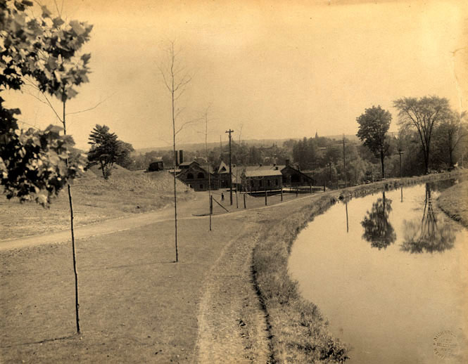
|
"Head
of Plane 10 East, Montville." [looking north; the bridge is
Route 202]
|
!["Head of Plane 10 East, Montville." [looking north; the bridge is Route 202]](images/szmor001/SZMOR001-030sm.gif) |
31.
|
"Montville,
from Head of Plane 8 East." [looking north]
|
!["Montville, from Head of Plane 8 East." [looking north]](images/szmor001/SZMOR001-031sm.gif) |
32.
|
"Montville
from Plane 8 East." [looking north toward the top of Plane
9 in the distance]
|
!["Montville from Plane 8 East." [looking north toward the top of Plane 9 in the distance]](images/szmor001/SZMOR001-032sm.gif) |
|
!["Near Van Winkle's Tavern, East of Paterson." [looking north]](images/szmor001/SZMOR001-018.jpg)

!["Mead's Basin west of Little Falls." [Mountain View; may be the Pompton River, looking south toward the Pompton Aqueduct]](images/szmor001/SZMOR001-021.jpg)
!["Canal, showing Pompton Feeder, near Mountain View." [looking north up the Pompton Feeder from the main line of the canal; the bridge is the towpath bridge over the mouth of the feeder]](images/szmor001/SZMOR001-024.jpg)
!["Canal at Pompton Feeder Junction." [looking west on the main canal; New York and Greenwood Lake Railroad]](images/szmor001/SZMOR001-025.jpg)
!["The Canal crossing the Pequannock River." [actually the Pompton River, looking north]](images/szmor001/SZMOR001-026.jpg)
!["Canal at Whitehall." [Montville]](images/szmor001/SZMOR001-027.jpg)
!["Beavertown." [Lincoln Park; looking south toward Lower Montville, not Beavertown; plane house for Plane 9 East can be seen in left background]](images/szmor001/SZMOR001-028.jpg)
!["Head of Plane 10 East, Montville." [looking north; the bridge is Route 202]](images/szmor001/SZMOR001-030.jpg)
!["Montville, from Head of Plane 8 East." [looking north]](images/szmor001/SZMOR001-031.jpg)
!["Montville from Plane 8 East." [looking north toward the top of Plane 9 in the distance]](images/szmor001/SZMOR001-032.jpg)