 Official Site of The State of New Jersey
Parcels
Parcel boundaries are a crucial component of our framework GIS datasets. While these parcels are not based on survey data, they facilitate graphical-based analysis and visualization of essential tax assessment information, such as property ownership, tax distribution, exempt properties, and land use. They also support various planning activities, including analyzing vacant and developed land, zoning, preserved open spaces, and flood zones.
The statewide parcel composite is an integration of each county's parcel data, edge-matched across county lines by NJOGIS. While each county maintains its own parcel data, the composite is updated as new information is received from them.
Developed between 2008 and 2014 during the Parcels Normalization Project, the statewide composite of parcels (cadastral) data for New Jersey was created by NJOGIS. This normalized parcels data aligns with the New Jersey Department of Treasury's MOD-IV system, currently utilized by Tax Assessors, and serves as a key framework GIS dataset for New Jersey. Although county and municipal governments are responsible for data stewardship and maintenance, NJOGIS maintains the statewide composite. Parcel attributes adhere to the New Jersey GIS Parcel Mapping Standard, ensuring a consistent structure and a parcel identification number (PIN) that matches the PIN in the Property Assessment Management System (PAMS) database.
The normalization process used statewide municipal, county, and state boundary data from NJOGIS as the spatial framework to align parcel data accurately. As a result, the normalized parcels are correctly edge-matched across most municipal boundaries, with some exceptions noted earlier. During this process, improvements were made to the municipal, county, and state boundary data.
Please note that the polygons in the dataset do not represent legal boundaries and should not be used for legal determinations of land ownership. Parcels are not survey data and should not be treated as such.
For the most current county parcels data, please reach out directly to the county parcels Data Steward. County parcels may not be edge-matched with adjacent counties.
Redaction of owner names from parcels and tax list database
In compliance with the provisions and protections afforded the personally identifiable information of certain persons, as enacted by Daniel’s Law (P.L. 2020, c. 125), the NJ Office of GIS has redacted owner names from all hosted parcels and tax list database downloads, map services and applications.
Additional Resources
Parcels Update Log
Parcel Mapping Standard
MOD-IV User Manual
Property Explorer App
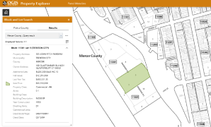
Search all parcels in NJ by address, county, municipality, block and lot.
Link
Statewide Parcels joined with MOD-IV
Web Mercator (Auxiliary Sphere)
Link
Statewide Tax Blocks
New Jersey State Plane
Link (both streaming and download)
Parcels Basemap
Visit NJGIN Basemaps for details.
Statewide Parcels joined with MOD-IV
New Jersey State Plane
File Geodatabase
Statewide Parcels
New Jersey State Plane
File Geodatabase
Statewide MOD-IV Table
Parcels & MOD-IV
New Jersey State Plane
File Geodatabase
Shapefile
Parcels & MOD-IV
New Jersey State Plane
File Geodatabase
Shapefile
Parcels & MOD-IV
New Jersey State Plane
File Geodatabase
Shapefile
Parcels & MOD-IV
New Jersey State Plane
File Geodatabase
Shapefile
Parcels & MOD-IV
New Jersey State Plane
File Geodatabase
Shapefile
Parcels & MOD-IV
New Jersey State Plane
File Geodatabase
Shapefile
Parcels & MOD-IV
New Jersey State Plane
File Geodatabase
Shapefile
Parcels & MOD-IV
New Jersey State Plane
File Geodatabase
Shapefile
Parcels & MOD-IV
New Jersey State Plane
File Geodatabase
Shapefile
Parcels & MOD-IV
New Jersey State Plane
File Geodatabase
Shapefile
Parcels & MOD-IV
New Jersey State Plane
File Geodatabase
Shapefile
Parcels & MOD-IV
New Jersey State Plane
File Geodatabase
Shapefile
Parcels & MOD-IV
New Jersey State Plane
File Geodatabase
Shapefile
Parcels & MOD-IV
New Jersey State Plane
File Geodatabase
Shapefile
Parcels & MOD-IV
New Jersey State Plane
File Geodatabase
Shapefile
Parcels & MOD-IV
New Jersey State Plane
File Geodatabase
Shapefile
Parcels & MOD-IV
New Jersey State Plane
File Geodatabase
Shapefile
Parcels & MOD-IV
New Jersey State Plane
File Geodatabase
Shapefile
Parcels & MOD-IV
New Jersey State Plane
File Geodatabase
Shapefile
Parcels & MOD-IV
New Jersey State Plane
File Geodatabase
Shapefile
Parcels & MOD-IV
New Jersey State Plane
File Geodatabase
Shapefile