 Official Site of The State of New Jersey
Metadata Support
  |
What are metadata?
In simple terms, metadata are just structured "data about data." Metadata about data layers are like nutrition labels on food packaging but contain much more information. The information in the metadata provides context for the data and supports the effective application of the data by answering questions such as:
- Who developed the data?
- When were the data collected?
- How were the data processed?
- How are the data attributes defined?
- In what formats are the data available?
- How does one obtain the data?
What does “structured” data actually mean?
Most metadata are stored as an eXtensible Mark-up Language (XML) file. Such a structure enables easy machine reading of the metadata. That’s great for your GIS software and interoperability between GIS platforms, but the trick is that there are many ways to organize your metadata in XML and you need to know which one to use!
The format for metadata in New Jersey is the Federal Geographic Data Committee’s Content Standard for Digital Geospatial Metadata (FGDC-CSDGM), often just called CSDGM. The FGDC also supports other “flavors” of metadata, but we use CSDGM in New Jersey.
- Full FGDC-CSDGM metadata is considered best practice and is the State of NJ standard for metadata.
- NJOGIS is not planning to transition to the International Organization for Standardization (ISO) 19115 Style ArcGIS metadata at this time.
Why write full metadata for my geospatial data?
- To enable potential users (including the data creator, after time marches on) to understand the dataset and its quality in detail and assess its fitness for the use intended.
- To satisfy State of New Jersey spatial data delivery requirements for vendors.
- To protect creators and distributors when sharing data. A structured geospatial metadata record may be used to specify responsibility and to disclaim it.
- If you are a state agency, it is required.
Have no fear! NJGIN Core is here!
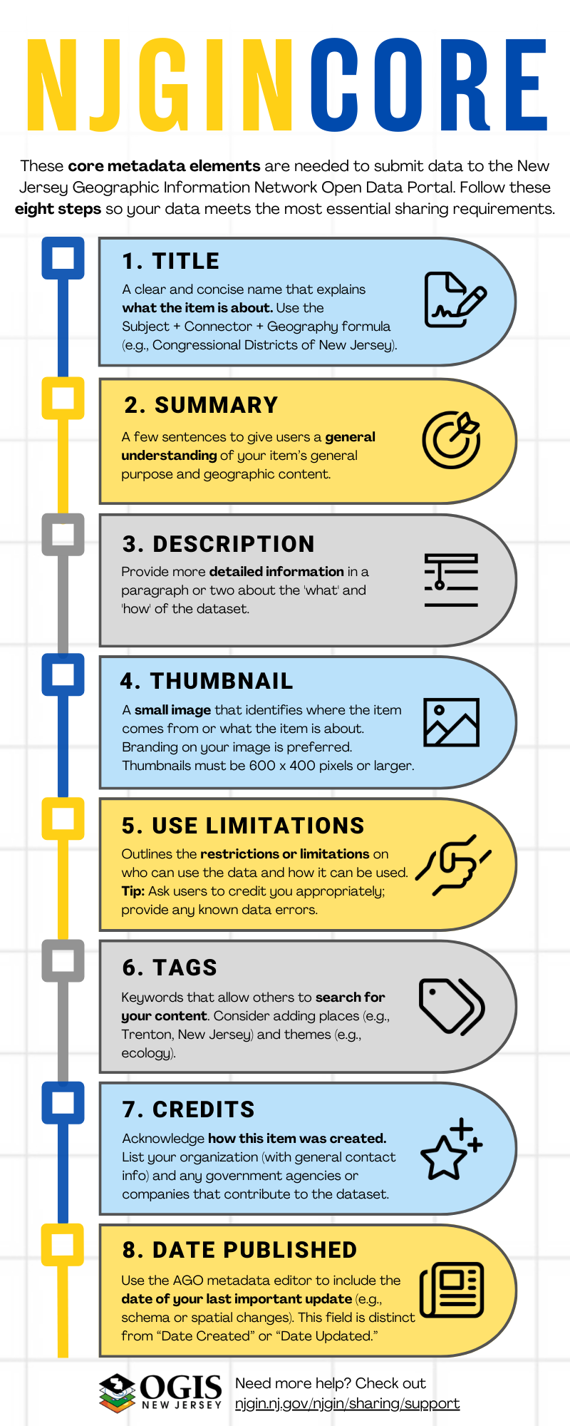
With the new NJGIN Core specification, it is now easier and faster than ever to document your content for NJGIN Open Data. NJGIN Core can also be used for documenting GIS emergency response incidents. NJGIN Core is a subset of the FGDC-CSDGM, consisting of only eight essential elements. It is quicker to author and enough to describe your content for NJGIN Open Data.
- NJGIN Core Infographic
- NJGIN Core Instructional Video
- Please note: If you already have full FGDC-CSDGM metadata, you are all set. Please do not remove items to match NJGIN Core.
Metadata requirements for sharing your data with NJGIN Open Data
- Metadata in ArcGIS format, FGDC-CSDGM style.
- Correct and current entries for the NJGIN Core specification.
- Metadata incorporated into the ArcGIS Online item to be shared with NJGIN Open Data.
ArcGIS Pro
Use the ArcGIS Pro metadata editor to write and update ArcGIS format, FGDC-CSDGM style metadata. This option is good for ArcGIS Pro users, especially those who plan to publish hosted layers using ArcGIS Pro.
NJGIN Core for ArcGIS Pro Metadata Editor
NJOGIS has developed the following abbreviated collection of required metadata elements to support search and facilitate publishing on NJGIN Open Data, called NJGIN Core:
Writing Full Metadata using ArcGIS Pro Metadata Editor
Create metadata that fully document the data using the ArcGIS Pro metadata editor. This option is good for those who want to use ArcGIS Pro tools to write and maintain metadata.
- ArcGIS Metadata Required Elements Lists for NJGIN Core and Full Metadata
- Twenty Questions about Geospatial Data for Writing Full Metadata
If you have an FGDC-CSDGM XML file format metadata record, you will need to upgrade your document to the ArcGIS XML format. NJOGIS has authored the following document providing some guidance on this process.
ArcGIS Online
Use the ArcGIS Online metadata editor to write and update ArcGIS format, FGDC-CSDGM style metadata. This option is good for those who are new to writing metadata and who want to use a simple interface. Learn how to enable metadata in your ArcGIS Online organization here.
NJGIN Core for ArcGIS Online Metadata Editor
NJOGIS has developed the following abbreviated collection of required metadata elements to support search and facilitate publishing on NJGIN Open Data, called NJGIN Core:
Writing Full Metadata using ArcGIS Online Metadata Editor
Create metadata that fully document the data using the ArcGIS Online metadata editor.
Geospatial Metadata Standards
FGDC Metadata Page
FGDC-CSGDM Standard
FGDC-CSDGM Workbook
US Geological Survey (USGS) Metadata Page
USGS Formal Metadata: Information and Software
Illustrated guide to complete FGDC metadata (old version for ArcMap but still useful)
NJDEP Mapping and Digital Data Standards
Geospatial Metadata Tools
Esri Platforms
ArcGIS Online Metadata Editor Help
ArcGIS Pro Metadata Editor Help
Free Geospatial Metadata Editors
USGS Metadata Wizard
US Environmental Protection Agency (EPA) Metadata Editor
USGS FGDC-CSDGM Metadata Validation Service
Alaska Data Integration Working Group (ADIwg) mdEditor
Additional ADIwg Metadata Tools
Still have questions?
Feel free to Contact Us, we are happy to help!