Delaware • New Jersey • Pennsylvania
New York • United States of America
OCTOBER 1903
Record rainfall in October 1903 caused record flooding in the Delaware River Basin.
AUGUST 1955
The back-to-back rain events resulting from remnants of Hurricanes Connie and Diane in August 1955 caused record flooding in the Delaware River Basin. The 1955 flood killed 99 people in the Delaware River Basin.
To this day, the flooding experienced during the Great Flood of August 1955 remains the Delaware River's flood of record.
JANUARY 1996
Heavy rains, balmy temperatures, and rapid snowmelt caused serious flooding in the Delaware River Basin during January 1996, with flows on the Delaware River the highest since the record flood of 1955.
The crest for the Delaware at Trenton, N.J. was 22.20 feet on January 20, or 2.20 feet above flood stage.
During the August 1955 flood, the river rose 8.60 feet above flood stage.
As the floodwaters surged downstream, an ice jam in the Delaware near the Delaware Water Gap broke up, causing rapid rises in water levels downstream of Stroudsburg, Pa.
At Belvidere, N.J., some 10 miles below the Gap, the river rose over six feet in less than 30 minutes.
Water levels exceeded flood stage by nearly seven feet at Riegelsville, N.J. and over five feet at Yardley, Pa.
Evacuations and road closures occurred along the Delaware and many of its tributaries.
Learn more about this flooding event:
SEPTEMBER 1999
- Hurricane Floyd (pdf) spread heavy rainfall throughout the basin on September 16, 1999, producing six- to 10-inches over an 18-hour period.
Extensive flooding damage occurred along tributaries in the lower portion of the basin.
Several people lost their lives and many homes were severely damaged. In addition, the transportation system was disrupted and a number of bridges were destroyed.
Learn More:
JUNE 2001
Significant flooding also was produced by remnants of Tropical Storm Allison, which moved through the basin June 16-17, 2001.
Allison generated heavy rainfall over roughly a 24-hour period, with two- to four-inches of precipitation common throughout much of the area.
However, some lower basin communities in Bucks and Montgomery Counties in Pennsylvania received up to 10 or more inches of rain. Such copious amounts of rain in a short period of time resulted in several streams overflowing their banks.
As a result of the flooding produced by Allison, hundreds of properties and several bridges sustained damage.
Most tragically, seven people lost their lives in Montgomery County. This storm is blamed for over 40 deaths across the country.
SEPTEMBER 2003
September 2003 was a time of substantial rainfall, floods, tornados, and a hurricane.
During the first three days of the month, an average of five inches of rain fell over the New York City Delaware reservoirs, resulting in storage gains of more than 12.5 billion gallons. The increase in storage was enough to fill the reservoirs to above capacity, resulting in excess water spilling into both the east and west branches of the Delaware River.
Heavy rains struck again on September 15, this time further south in the basin, as an intense storm pounded western Chester County in Pennsylvania. Up to eight inches of rain fell in some locations and more than 400 homes were flooded.
The puddles from the September 15th storm barely had time to dry before Hurricane Isabel was threatening to drop additional rain on already saturated soils.
Fortunately, the hurricane lost much of its intensity as it tracked to the west of the basin on September 18 and 19, leaving more wind than rain in its path.
Rainfall totals between 0.5 inches and 1.5 inches were common across the basin, with higher amounts of two- to three-inches reported in parts of Delaware.
Moderate flooding occurred along the Christina River at Coochs Bridge and a tidal surge up the Chesapeake and Delaware Bays produced moderate to severe tidal flooding. Downed trees and power outages plagued many residents in the basin for several days after Isabel departed.
Unfortunately, September's weather woes did not exit with Isabel. On the morning of September 23, a cold front produced a band of powerful storms that dropped two- to three-inches of rain on parts of the basin.
The sudden rainfall, in combination with the already saturated ground and higher than normal streamflows, produced flash floods in the northeastern Pennsylvania towns of Tannersville and South Whitehall.
Additional flooding occurred along the Brandywine and Christina Rivers, as well as the Red and White Clay Creeks.
These storms also spawned four confirmed F1 tornadoes in the basin across Pennsylvania and New Jersey.
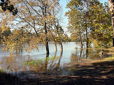
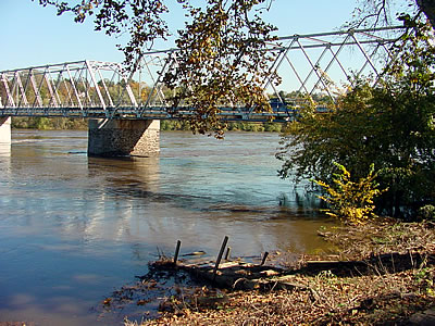
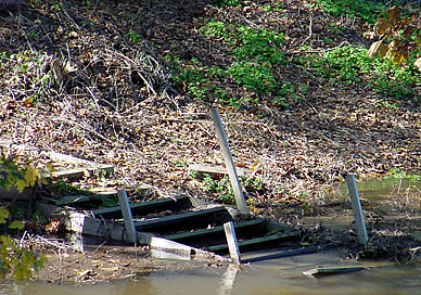
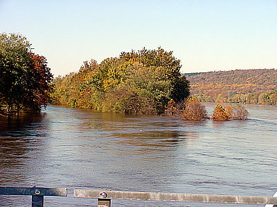
View Images of a Rain-Swollen Delaware River -- October 30, 2003

JULY 2004
On July 12-13, 2004, a slow moving system dropped rainfall averaging four- to six-inches on the lower basin.
Portions of south-central New Jersey were the hardest hit as more than a foot of rain fell in some localities.
As a result, as many as 25 roads were closed due to rising waters and hundreds of residents had to be evacuated from their homes. A total of 17 dams in southcentral New Jersey were either totally or partially breached and many creeks and streams flooded their banks.
A state of emergency was declared in Burlington County on July 13.
On July 16, President George W. Bush declared the county a federal disaster zone, opening the way to federal aid for flood damages. Adjacent Camden County also was made eligible for federal aid.
Communities especially hard hit by the July 12-13 storm included:
- Tabernacle, Burlington County, New Jersey: 13.2 inches of rain fell in what was determined to be a one-in-one-thousand year storm.
- Pottsville, Berks County, Pennsylvania: Six inches of rain sent a landslide into a bowling alley. Fortunately, there were no injuries.
- Smyrna, Kent County, Delaware: More than 10 inches of rain was received, closing US Route 13 and Delaware Route 1 to all traffic near Smyrna for several hours. The National Weather Service (NWS) reported this to be the worst 24-hour rainfall since Hurricane Floyd in 1999.
Learn More:
- Radar Image of Estimated Rainfall Across the Basin on July 12 (pdf 51 KB)
- NWS Storm Report for July 12-13
- U.S. Geological Survey (USGS):
- Burlington and Camden Counties, South-Central New Jersey (Flood Summary)
- Burlington and Camden Counties, South-Central New Jersey (SIR 2006-5096)
- Burlington and Camden Counties, South-Central New Jersey (Flood Summary)
- July 2004 Delaware River Basin Rainfall Map (pdf 679 KB)
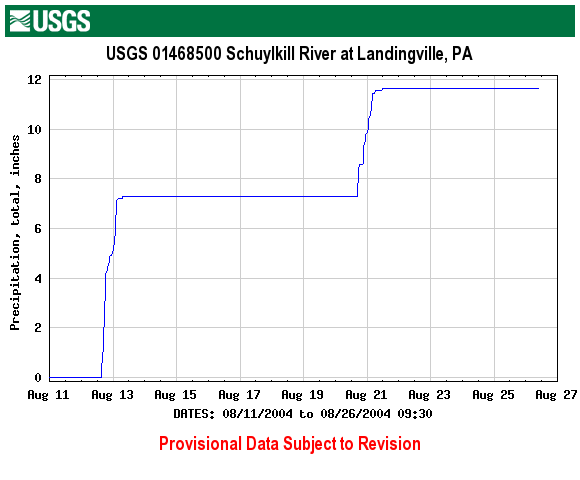
AUGUST 2004
On August 1, 2004, heavy rain affected portions of the lower basin.
Two communities that bore the brunt of the storm were Upper Darby and Darby Borough in Delaware County, Pennsylvania, where more than five inches of rain fell.
Darby Borough declared a state of emergency after 80 families were displaced by flooding. Elsewhere in the region, intense rains temporarily shut down Philadelphia's Broad Street Subway and SEPTA's regional railways. Portions of the Schuylkill Expressway were closed due to mudslides.
On August 5, Pennsylvania Governor Rendell declared a state of emergency to allow flood victims in Philadelphia, Delaware, and Montgomery counties to apply for grants and low interest loans. More than four million dollars in damages is estimated for the August 1, 2004 storm.
Severe weather threatened again by mid-August, as a strong storm system and two tropical storms were forecast to drench the Delaware River Basin over a three-day period. During the evening of August 12, storms rolled through the basin producing more than seven inches of rain over the headwaters of the Schuylkill River. Elsewhere in the basin, some localities in Monroe County, Pennsylvania were estimated to have received six to eight inches of rain. The August 12 storm left many streams and rivers flowing far above normal levels, creating a worrisome situation as two tropical storms were fast approaching from the south.
On August 13, forecasters were anticipating the arrival of Tropical Storm Bonnie. With the basin's streams and rivers already brimming from the storms the night before, there was a potential for serious flooding. Fortunately, Bonnie only affected the very southern portion of the basin with moderate rainfall.
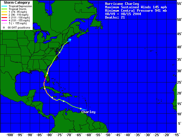
On August 14, the basin was gearing up for another potential soggy blow, this time from Tropical Storm Charley. Charley had devastated portions of southwestern Florida as a Category Four hurricane and was forecasted to track along the basin, almost on top of the Trenton area.
Southern New Jersey and portions of Kent and Sussex counties in Delaware received one- to two-inches of rain, with slightly higher amounts at the very southern tip of Delaware.
SEPTEMBER 2004
The remnants of Tropical Storm Ivan, interacting with a cold front which dropped into the northeastern United States late Friday, September 17, 2004, produced tremendous rainfall amounts across northeast Pennsylvania and southern New York.
Most of the Delaware River Basin upstream of Trenton received three- to five-inches of rain in a 12-hour period, with some isolated areas receiving as much as seven or eight inches.
Much of the heavier rain occurred in the mountainous regions of the basin in the Poconos and Catskills, while many areas in the southern half of the watershed received an inch or less. This rain fell on soils already saturated by a wet summer, including Tropical Storm Frances (pdf) just a week before, creating a "parking lot" runoff effect over a very large portion of the basin's drainage area. Even before the rains from Ivan arrived, the Delaware River at Montague and Trenton, N.J. was flowing at 298 percent and 265 percent of normal, respectively, for the first half of September.
The flooding on the main stem Delaware River was the worst since August 1955 when the basin was hit by the remnants of two hurricanes, Connie and Diane, in one week. The 1955 flood killed nearly 200 people in the eastern U.S., including 99 lives in the Delaware River Basin. No fatalities have been reported in the basin as a result of Ivan, thanks in large part to the efforts by the National Weather Service, emergency management officials (including police, fire, and other rescue personnel), and the media, among others.
New warning products and other tools that were developed or upgraded since the last time major flooding occurred along the Delaware in January 1996, such as Advanced Hydrologic Prediction Service (AHPS), helped to provide the necessary lead time to get hundreds of people out of harms way.
A number of affected basin counties in Pennsylvania, New Jersey, and New York were declared as federal disaster areas.
Learn More:
- Overview of Delaware River Flooding from Remnants of Tropical Storm Ivan (pdf 1 MB)
- September 2004 Delaware River Basin Rainfall Map (pdf 668 KB)
- NWS Mid-Atlantic River Forecast Center Flood Information (pdf)
- September 2004 -- Remnants of Tropical Storm Ivan: County Reported Damages (pdf 355 KB)
- USGS New Jersey District Office Storm Summary
- USGS New York District Office Report on the Flood in the Upper Basin/N.Y.
On September 28, 2004, the remnants of Tropical Storm Jeanne brought four- to eight- inches of rain to the Philadelphia metropolitan area, primarily in Delaware, Pennsylvania, and New Jersey north of the"Fall Line" (a geologic divide that separates the Coastal Plain from the more highly elevated Piedmont region to the west).
The heavy precipitation caused widespread urban and small stream flooding. Streams from northern Delaware to central New Jersey rose rapidly above flood stage during the evening hours, making roadways hazardous and evacuation difficult.
Though flash flooding conditions had been predicted by the National Weather Service, precipitation amounts were even higher than expected in some areas.
APRIL 2005
Two early spring rainstorms -- the first on March 28-29 and a second on April 2-3, 2005 -- combined with snowmelt to cause major flooding in the Delaware River Basin.
Along the main stem of the Delaware River, the flood crests exceeded those reached in Tropical Storm Ivan only six-and-a-half months earlier, and again caused evacuations, bridge and road closures, and extensive damage.
Learn More:
- NWS Model Simulations for the Upper Delaware River Basin Flooding of April 2005 -- Report (pdf 127 KB) & Presentation (pdf 369 KB)
- DRBC Flood Summary (pdf 704 KB)
- Informational Workshop For Public Officials
- Delaware River Flood Advisory Committee: A Partnership to Support Flood Mitigation (pdf 2.8 MB)
- NWS Mt. Holly, N.J. Office Storm Summary for April 2005 Flooding
- NWS Binghamton, N.Y Office April 2005 Flood Summary
- NWS Mid-Atlantic River Forecast Center April 2005 Flood Information (pdf)
- USGS: Delaware River Main Stem from Port Jervis, New York, to Cinnaminson, New Jersey (Flood Summary)
- USGS: Delaware River Main Stem from Port Jervis, New York, to Cinnaminson, New Jersey (SIR 2007-5067)
- USGS Report on the April 2-3, 2005 Flood in the Neversink Subbasin
- Earth Observatory -View the Delaware Bay Colored by the April Floods
- April 2005 Flood Event: County Reported Damages (pdf 359 KB)
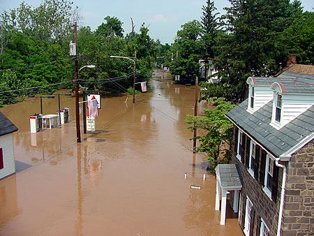
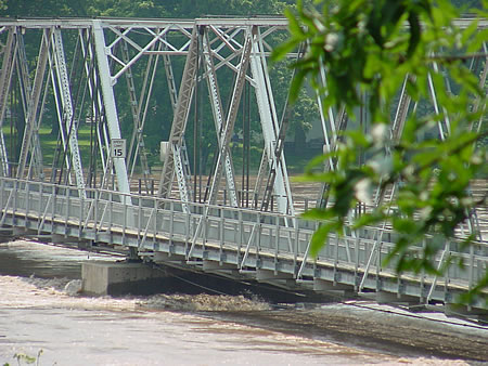
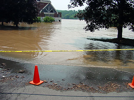
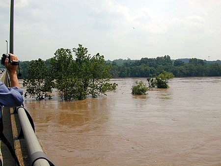
JUNE 2006
Extremely heavy rainfall over the Delaware River Basin during the June 24-28 period caused flash flooding and record to near-record flood crests along many streams and rivers throughout the basin, including the main stem Delaware River.
Although hydrologic conditions were normal to dry prior to Saturday, June 24, the broad area of the rainfall and its intensity in the western half of the basin produced the flooding.
National Weather Service data indicate that six to over 15 inches of rain fell in the Schuylkill, Lehigh, and upper Delaware River watersheds during the period.
At least five inches fell throughout nearly all of the Delaware River Basin, with the exception of portions of New Jersey and the immediate Philadelphia area which received less.
Heavy rainfall during June 24-26 saturated the ground and produced bank full and minor flooding conditions by early Tuesday, June 27. This set the stage for high runoff potential for any additional precipitation that fell. Then, precipitation on June 27 and early on Wednesday, June 28 produced an additional two to over six inches of rainfall in the Schuylkill, Lehigh, and Lackawaxen watersheds as well as in Sullivan and Delaware counties in New York State. The high rate of runoff combined with the already bank full conditions to produce the near-record flooding conditions.
During the evening of June 27, National Weather Service flash flood warnings were in effect for nearly all counties in the Pennsylvania and New York portions of the basin.
The flood crests on the main stem Delaware River occurred on June 28 and 29.
Preliminary Crest Heights From USGS Hydrographs:
- Main Stem Points (pdf 124 KB)
- Upper Basin Points (pdf 137 KB)
- Brodhead Point (pdf 23 KB)
- Lackawaxen Points (pdf 67 KB)
- Lehigh Points (pdf 51 KB)
- Schuylkill Points (pdf 96 KB)
Learn More:
- Flood Summary Prepared by DRBC Staff (pdf 30 KB)
- Presentations by NWS Staff (pdf 12 MB) and DRBC Staff (pdf 1.3 MB) at July 2006 DRBC Meeting
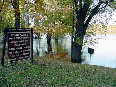
- Testimony of DRBC's Executive Director Before the U.S. House Committee on Financial Services at its August 15, 2006 Field Hearing Held in Yardley, Pa. (pdf 65 KB)
- NWS Reservoir Model Simulations for the June 2006 Delaware River Basin Flood
- NWS Precipitation Maps (pdf 1.1 MB)
- NWS Binghamton, N.Y Office June 2006 Weather Information
- NWS Mt. Holly, N.J. Office June 2006 Weather Information
- NWS Mid-Atlantic River Forecast Center June 2006 Information (pdf)
- USGS: 2006 Flood Event - New Jersey
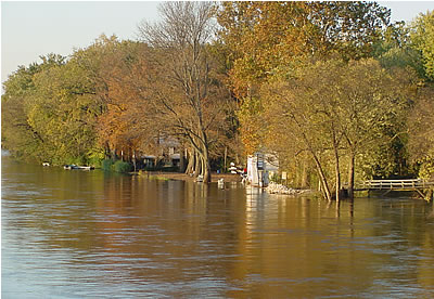
Photos
AUGUST 2011
August 2011 was the wettest August on record in Philadelphia based on data collected since 1872.
The record rainfall of 12.10 inches for August was broken on August 19, 2011 when the accumulated rainfall for the month reached 12.24 inches.
On August 27-28, Hurricane Irene traveled up the east coast delivering widespread rainfall in amounts of five to eight inches of rainfall, with locally higher amounts of up to 12 inches in the State of Delaware. The Pocono and Catskill regions received approximately three to five inches of rainfall.
The total rainfall for the month of August 2011 in Phila. was 19.31 inches, which exceeded the all-time maximum monthly accumulation of 13.07 inches, which occurred in September 1999.
Tropical Storm Lee followed shortly thereafter from September 5th through September 9th. Approximately five to seven inches of precipitation fell over much of the basin, with lesser amounts of two to four inches recorded in the estuary region of the lower basin. Portions of the Schuylkill watershed and western New Jersey received larger amounts of precipitation in the range of seven to 10 inches.
- DRBC staff prepared a report (pdf 2.2 MB) summarizing the flooding that occurred in late August and early September.
In addition, DRBC has been working on a method for animating time series data collected from continuous monitors throughout the basin. This treatment of the data integrates and synchronizes various data sets, building understanding of the interplay of the various characteristics being measured. The animated graphs are produced using VBA Excel, the programming language behind MS Excel.
Two time-series data collections have been animated to date:
An animated graph of the impact of Hurricane Irene and its storm surge on Delaware Estuary water surface elevations. The graph animates predicted and observed water surface elevations from the NOAA PORTS system, flow at Trenton, NJ and Philadelphia, PA from the USGS NWIS monitors, and the track of the eye of Hurricane Irene (pdf). The graph demonstrates the increasing deviation between the predicted and observed water surface elevation as the storm surge impacts the mouth of the Bay and propagates upstream, followed by flood flows at Trenton and Philadelphia.
This video shows the development of back-to-back flood events on the non-tidal Delaware River resulting from Hurricane Irene and Tropical Storm Lee, as captured by the USGS NWIS gages in the Delaware River. The video also includes the flood thresholds, expressed in units of discharge/drainage area.
For additional information on these animated graphs, please contact John Yagecic at 609-883-9500 ext. 271.
Two events in 2020 caused flooding on Delaware River Basin tributaries and the main stem Delaware River.
AUGUST 2020
On August 3 and 4 the remnants of Hurricane Isaias passed over the basin after it was downgraded to a tropical storm. Flooding occurred on the Schuylkill River and its tributaries, as well as the Little Lehigh due to Tropical Storm Isaias. There was widespread moderate flooding and isolated major flooding throughout the basin, including some of the tidal gages.
DECEMBER 2020
The basin experienced a strong winter storm earlier in December, followed by heavy rain on December 24. The precipitation (rain and snow water equivalent) was highest in Pennsylvania and Delaware; most areas received 1.5 inches or more. Several locations in the basin experienced flooding, including tidal areas and the main stem.
- View the 2020 Hydrologic Conditions Report (pdf) to learn more about these two storm events.
SUMMER 2021
The latter part of the summer was wet, and several storms did cause flooding on the main stem Delaware River and tributaries.
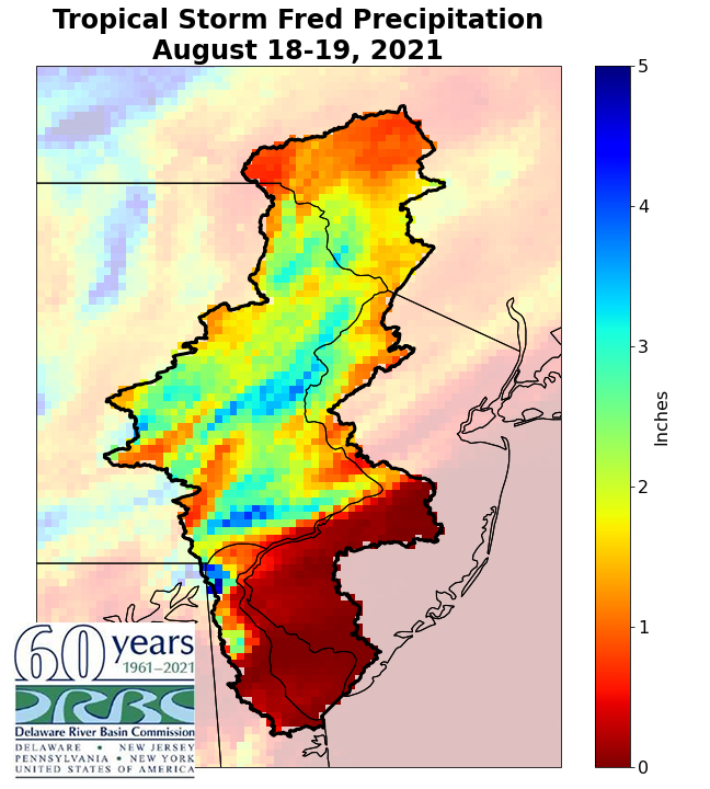
- Precipitation in the DRB from Tropical Storm Fred: August 18-19 (jpg)
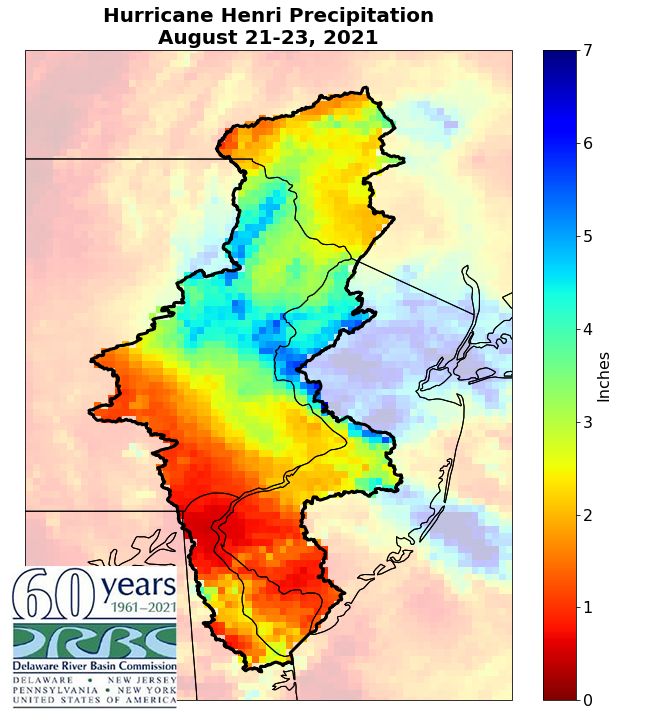
- Precipitation in the DRB from Tropical Storm Henri: August 21-23 (jpg)
SEPTEMBER 2021
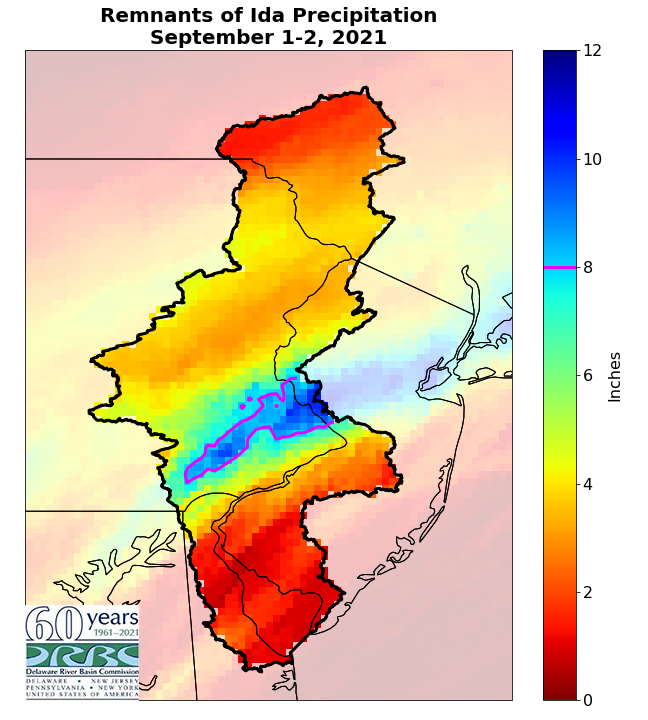
Remnants of Hurricane Ida caused flooding on multiple tributaries, including the Schuylkill and Lehigh rivers, from September 1-3. New records were set in several locations. The main stem Delaware River also was impacted by flooding.
- September 1 Update (pdf)
- September 2 Update (pdf)
- September 3 Update (pdf)
- Precipitation in the DRB from the Remnants of Ida: September 1-2 (jpg)
- Schuylkill River Discharge per Drainage Area: September 1-5, 2021 (YouTube)
- Schuylkill River Discharge Profile: Watch the River Rise & Fall, 8/12/21 - 9/5/21 (YouTube)
- Delaware River Discharge Profile: Watch the Non-Tidal River Rise & Fall, 8/12/21 - 9/5/21 (YouTube)
OCTOBER 2021
Heavy rainfall also caused flooding on the main stem Delaware River and several tributaries on October 27.
The tidal Delaware River also saw moderate to major flooding at several locations on the days following October 27.
ANNUAL INFO
APRIL 2022
Heavy rainfall on April 7-8 caused several points on the mainstem Delaware River to hit action, minor or moderate flood stage. The three New York City Delaware Basin reservoirs and several tributaries also hit action, minor or moderate flood stage.
- April 8 Update (pdf)
DECEMBER 2023
Heavy rainfall on December 17-18 caused flash flooding, coastal/tidal flooding and flooding on several Delaware River tributaries. A couple of points on the mainstem Delaware River hit action or minor flood stage.
JANUARY 2024
Heavy rainfall on January 9-10 caused flash flooding and Major, Moderate, Minor or Action Stage flooding to occur at several stream gages within the Basin, including those on tributaries, the non-tidal mainstem or tidal locations.