Delaware • New Jersey • Pennsylvania
New York • United States of America
What is Climate Change?
Climate change refers to fluctuations in the Earth's climate over a long period of time. Defined as the average of global or of a locale's weather patterns over an extended period of time, climate is different from normal variations in weather, which can change on a regional scale, hour to hour, day to day, season to season.
- Learn more about Climate Change with these links
- DRBC Climate Resilience Resource Hub for Practitioners
- DRBC Climate Resilience Plan
Climate Change Impacts
Changes in atmospheric temperature, precipitation and sea level, as well as their associated impacts to water resources, may create new challenges to meeting water quality, supply and flow management goals.
Looking Back: Droughts & Floods
To plan how best to address these challenges, water resource managers look at observed conditions, typically the most critical that has been experienced in a region.
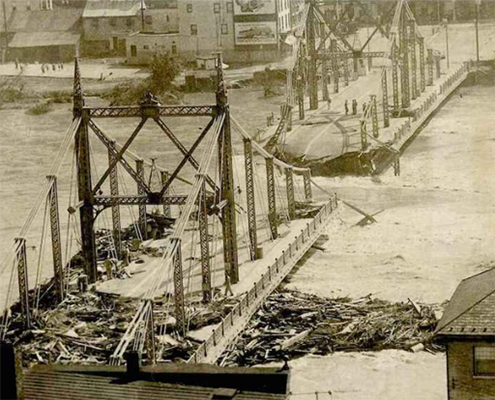
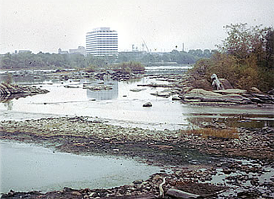
In the Delaware River Basin, both the flood of record and the drought of record occurred more than 50 years ago, in 1955 and 1962-1967, respectively.
 |
 |
| The Delaware River Basin's flood of record was August 1955. This photo shows the bridge between Easton, Pa. and Phillipsburg, N.J. wiped out during that flood. Photo courtesy of lehighvalleylive.com. |
The Delaware River Basin's drought of record occurred in the 1960s. This photo shows the Delaware River at Trenton, N.J. in July 1965. Photo from DRBC's archives. |
Climate change impacts for the Delaware River Basin include:
- Increased temperature
- Changes in Precipitation Patterns
- Sea Level Rise
DRBC is focused on how these impacts will affect flow management, water supply and water quality in the Basin. Staff tracks trends and changes in temperature, precipitation, streamflow and sea level rise to ensure resilient and sustainable water resources in a changing climate.
Temperature
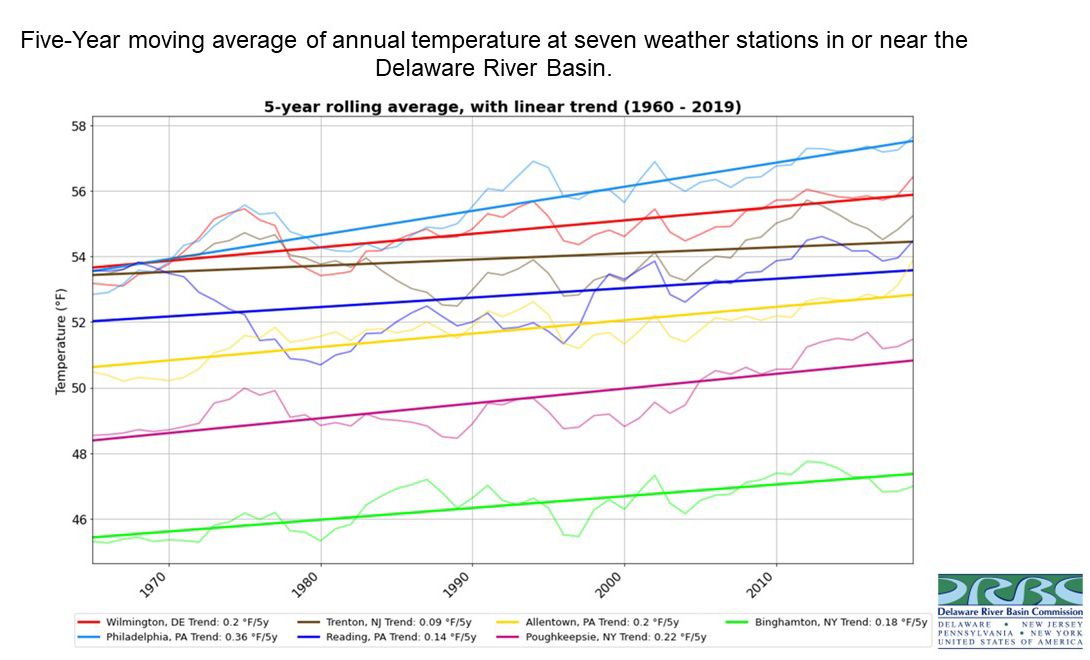
Average annual air temperature data from 1960 through 2019 at five weather stations inside the Basin and two nearby locations outside of the Basin (used due to lack of data within the upper Basin) suggest an increasing trend in temperature.
Temperatures in the upper Basin (Poughkeepsie, N.Y. and Binghamton, N.Y.) and lower Basin (Wilmington, Del. and Philadelphia, Pa.) have increased by more than 2°F. Temperatures mid-basin (Trenton, N.J.; Reading, Pa.; Allentown, Pa.) have increased by approximately 1°F (click for larger).
Here is another graphic showing (A) long-term temperature patterns at Philadelphia, Pa. and Allentown, Pa. Thin lines show annual average daily maximum temperature, thick solid lines show the same data averaged over a ten-year period and dashed black lines show the average trend over the period of record. (B) Annual number of days with temperatures below freezing over the past 60 years at Philadelphia, Pa. and Allentown, Pa. Thin lines show annual number of below-freezing days, thick solid lines show the same data averaged over a ten-year period and dashed black lines show the average trend over the past 60 years. As you can see, air temperatures are increasing, and the number of freezing days is decreasing at both locations (click for larger).
Precipitation
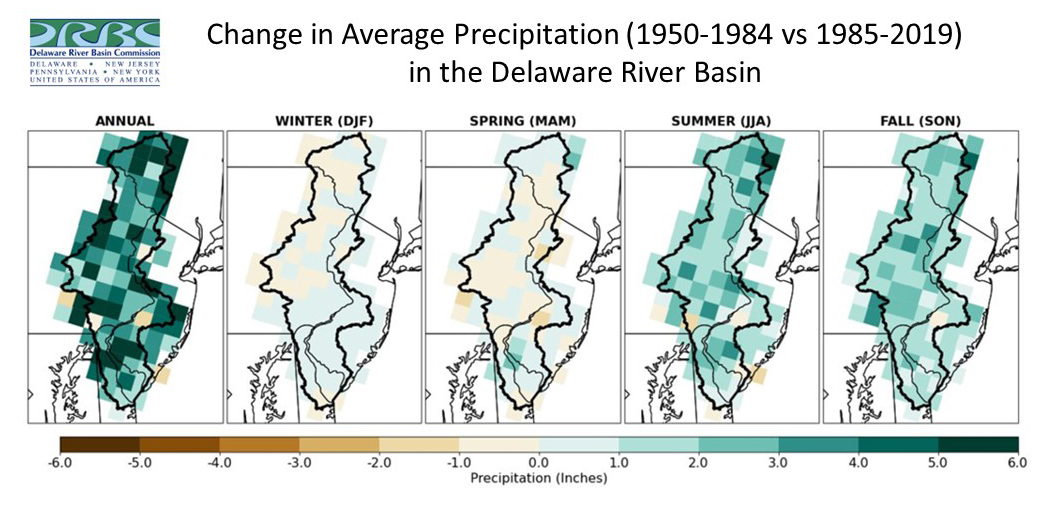
The DRBC looked at precipitation data annually and seasonally from 360 weather stations in the Basin. On an average annual basis, precipitation has increased in almost all areas. However, when looked at seasonally, there was not a single trend. Precipitation increases generally occurred in the summer (June, July and August) and fall (September, October and November). Winter precipitation (December, January, and February) showed a slight decrease in many areas of the upper Basin and a slight increase in most areas of the lower Basin. Spring precipitation (March, April, May) has decreased slightly in the middle Basin and mostly increased in the lower Basin. (click for larger)
Here is another graphic showing (A) long-term precipitation patterns at Philadelphia, Pa. and Allentown, Pa. Thin lines show annual average annual total precipitation, thick solid lines show the same data averaged over a ten-year period and dashed black lines show the average trend over the period of record. (B) Annual number of days with at least 1.5 inches of precipitation over the past 60 years at Philadelphia, Pa. and Allentown, Pa. Thin lines show annual number of high-precipitation days, thick solid lines show the same data averaged over a ten-year period and dashed black lines show the average trend over the past 60 years. As you can see, total precipitation and extreme precipitation that causes flooding are both projected to continue increasing in the Basin. There is still uncertainty in predicted precipitation changes. (click for larger)
Streamflow
Streamflows are affected by many factors; temperature, precipitation, evapotranspiration and land use can all alter the volume and timing of flow.
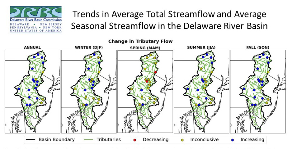
A trend analysis was performed with streamflow data from 20 representative USGS monitoring stations (with periods of record of 30-40 years) on tributaries to the Delaware River. As you can see from the figure below, there is great variation seasonally and across the Basin, and trends (increasing and decreasing) were weak. (click for larger)
Sea Level Rise
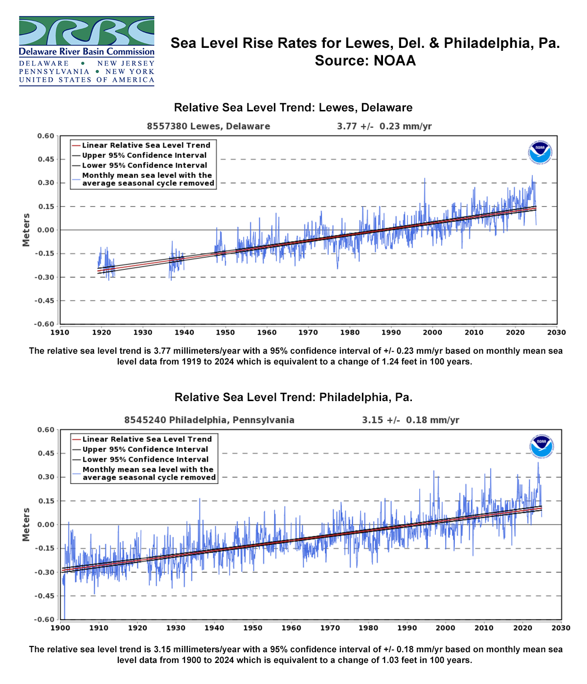
Sea levels are rising in the Basin, not only from storm and tidal flooding, but also from salinity intrusion. A change in sea level affects the overall volume of water in the Delaware Estuary and Bay, which can affect the movement of the salt front, increasing salinity in the upper portion of the estuary. This is a concern to human and aquatic life.
Below is a time-series of measured sea level at Lewes, Del., and Philadelphia, Pa., which show rates of SLR of 3.77 mm/yr and 3.15 mm/year, respectively. (click for larger)
Water Resource Management Concerns
- Increased temperatures will affect evapotranspiration rates; more evaporation means less water available for streamflow. Increased temperatures will also affect stream water quality; turbidity levels will likely increase, and dissolved oxygen levels decrease. A warmer atmosphere also holds more moisture.
- Precipitation is predicted to occur in the form of fewer, more intense storms occurring in the winter months. This means a potential increase in flood events coupled with extended drought cycles. Climate change can also increase the frequency, size and intensity of stalled weather events, known as blocking patterns, which can also impact precipitation.
- The seasonality of flows may also change, for example, less snowpack in the winter may cause lower flows in the spring.
- Sea level rise may require increased releases from reservoir storage to augment freshwater flows to repel salinity and/or costly modifications by public water suppliers to treat increases in dissolved solids and protect drinking water. Other water users south of Philadelphia may be impacted if increased salinity makes water resources unsuitable for conventional treatment.
- Changes in estuary salinity will also affect habitat for fish and shellfish, as well as impact wetlands and marshes.
- Climate change could also affect instream flow and temperature conditions for aquatic biota.
The DRBC has been examining the impacts of sea level rise and climate-induced changes to atmospheric temperature, precipitation and Basin hydrology for decades. Staff is performing modeling, research, and analytical studies to ensure an adequate, equitable and secure supply of suitable quality water for Delaware River Basin water users and the environment.
DRBC's Advisory Committee on Climate Change
In 2019, the DRBC established the Advisory Committee on Climate Change (ACCC) to provide the DRBC and the Basin community with scientifically based information for identifying and prioritizing these threats to the Basin's water resources, as well as recommendations for mitigation, adaptation and improved resiliency. The ACCC's role does not include the Compact's charge to the Commission to review projects under Section 3.8.
DRBC Partners with PEMA on Flood Mitigation
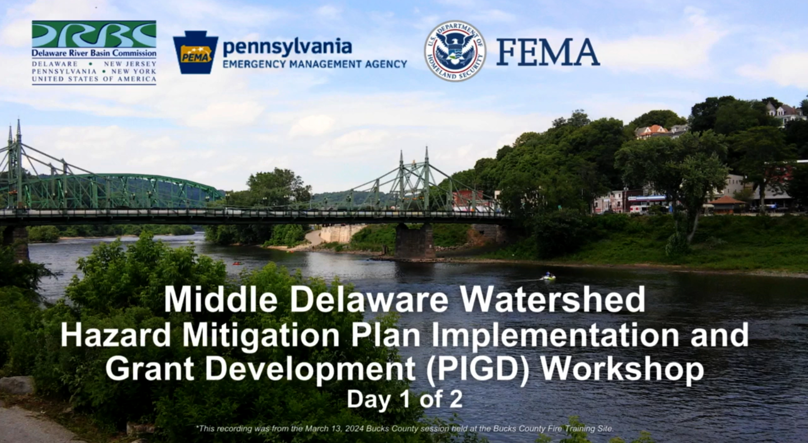
DRBC and the Pennsylvania Emergency Management Agency (PEMA) - with funding support from the Federal Emergency Management Agency (FEMA) - partnered in 2024 to hold Flood Mitigation Assistance Workshops to help increase the capacity of local municipalities to apply for grants and access state and federal resources. This grant round focused on the Middle Delaware counties of Bucks, Carbon, Northampton, Lehigh and part of Luzerne.
DRBC Modeling to Evaluate Climate Change Impacts

The DRBC is using multiple models to answer different questions related to climate change impacts on surface water supplies and flow management. Questions include: How far will salt travel upstream? How much water do we need to repel salinity, for water supply? Is there enough water at the right time? Does evaporation from higher temperatures offset increases in precipitation? What happens if there is no snowpack?
One is a three-dimensional hydrodynamic salinity model to look at how sea level rise could impact salinity intrusion in the Delaware River Estuary, focusing on the amount of freshwater needed to protect public water supply. Others include a rainfall/runoff model and reservoir and river models that look at precipitation intensity and timing and the adequacy and efficiency of our water supplies.
DRBC Releases New Interactive Tool to Project Extreme Precipitation
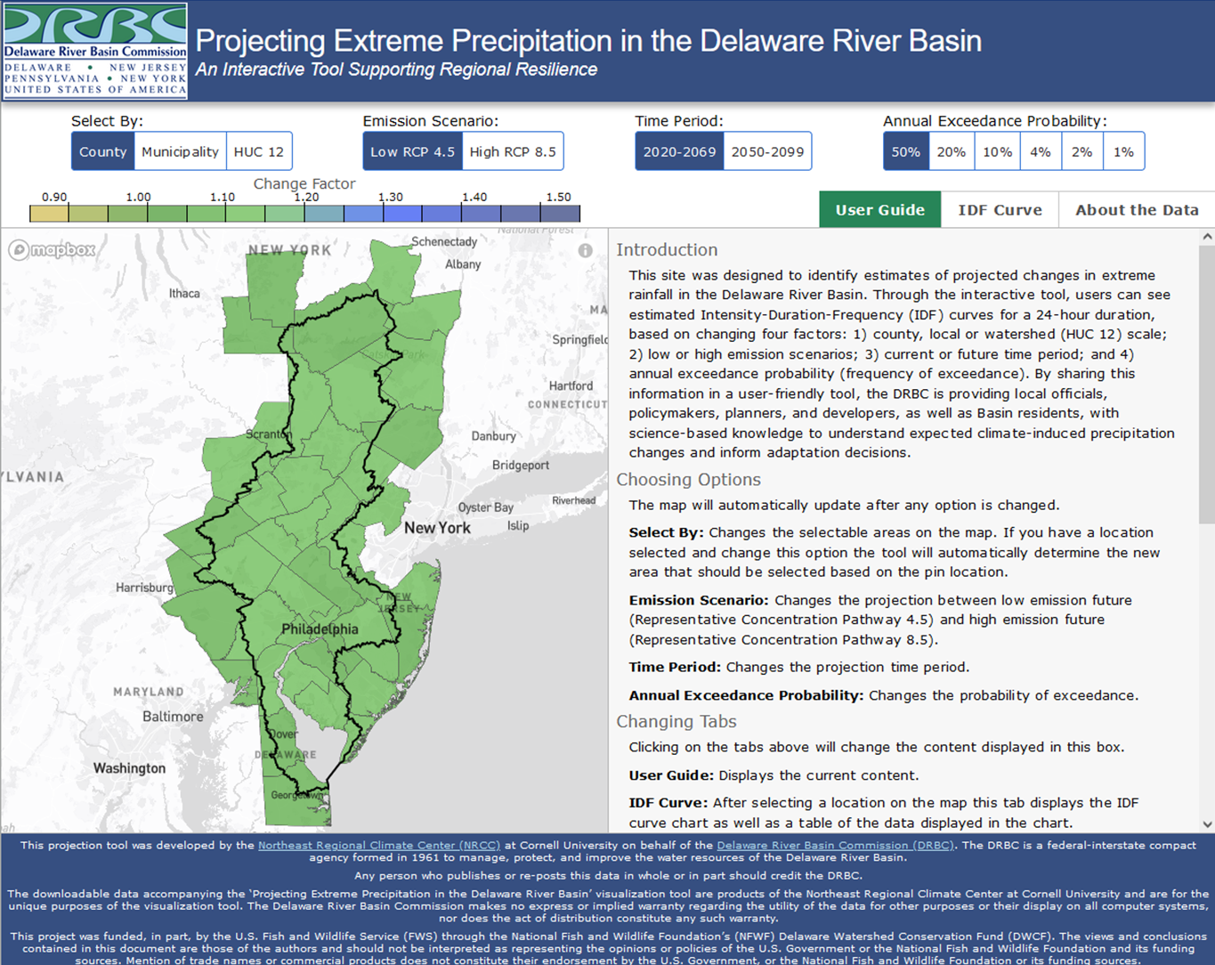

In March 2024, the DRBC released a new, interactive tool - Projecting Extreme Precipitation in the Delaware River Basin - to project extreme precipitation in the Delaware River Basin. The tool allows users to obtain estimates of future changes in intensity, duration and frequency (IDF curves) of extreme rainfall in the Delaware River Basin, thereby informing stormwater management and infrastructure design and increasing climate resilience.
- Learn More: Precipitation Mapping Tool
- The tool was developed with the Northeast Regional Climate Center (NRCC) at Cornell University
DRBC's Climate Resilience Plan

At its quarterly business meeting held June 5, 2024, the DRBC unanimously approved a resolution directing staff to develop a Climate Resilience Plan that includes elements related to planning, consultation, outreach, education and rulemaking concerning climate change.
The Climate Resilience Plan will connect multiple water resource impacts under one umbrella. DRBC's activities will focus on water resource matters within the authority and jurisdiction of the Commission. These do not include setting or implementing greenhouse gas-reduction goals. The Commission does not set energy policy for the nation, the region or its member states.
- Climate Resilience Plan Webpage
- Resolution 2024-4: A Resolution directing staff to develop a Climate Resilience Plan that includes elements related to planning, consultation, outreach, education, and rulemaking concerning climate change (pdf; approved June 5, 2024)
- View News Release Announcement (issued June 13, 2024)
DRBC & EPA Hold Climate Practitioners Workshop
On October 28, 2024, the DRBC and U.S. EPA Region 3 (Mid-Atlantic) held a free workshop to (1) give tribal, state and local leaders the information needed to execute climate adaptation projects and (2) create an ongoing Delaware River climate community that connects partners who need to work collaboratively to solve complex climate challenges.
Ongoing DRBC Efforts
- Establishing assumptions and scenarios to define a range of potential impacts due to sea level rise
- Incorporating methods to evaluate sea level rise into screening-level flow management models
- Evaluating historical trends for precipitation, temperature and flow and other water resource indicators from climate change
- Obtaining and analyzing downscaled global circulation model output for use in trend analysis and hydrologic models
- Using hydrologic models to develop flows for a range of scenarios to evaluate the Basin's vulnerability to future hydrologic conditions including drought
- Evaluating alternative flow management programs and outcomes
- Evaluating groundwater and surface water availability considering the effects of climate change
- Identifying additional freshwater storage and other adaptation measures to meet future water availability, climate adaptation, drought management and flow management needs
- Developing tools to evaluate the effects of climate change and sea level rise on aquatic habitat in tidal and non-tidal portions of the Delaware River
- Developing a framework for evaluating the impacts of climate change on water quality and emerging contaminants
- Providing technical analysis for Commission planning endeavors
- Performing a literature review and other assessments related to flooding to incorporate into a comprehensive climate change and sea level rise impact assessment
DRBC Reports/Presentations
- Building Blocks of Climate Resilience: Highlights from the Delaware River Basin Commission (September 2024; pdf)
- A Draft Framework for Developing DRBC's Climate Resilience Plan (September 2024; pdf)
- DRBC Climate Water Resources Program and Work Plans (December 2023; pdf)
- Potential Impacts of Sea Level Rise on Salinity in the Delaware Estuary (October 2022; pdf)
- Pennsylvania Coastal Resources Management Program: Sea Level Rise and Associated Effects in the Delaware Estuary Coastal Zone (DECZ) (September 2022; prepared by DRBC Water Resource Operations; pdf)
- Climate Change Planning at a Watershed Scale (May 2022; pdf)
- Climate Change Considerations in Water Resource Management (Oct. 2021; pdf)
- DRBC Deputy Exec. Director & ACCC Members Participate in Climate Change Webinar (Sept. 2020)
- EFDC Model Development and Simulations (Sea Level Rise) (pdf)
- DRBC-Hosted Webinar: Climate Change and NJ Water Resource Impacts (hosted for NJ-AWRA)
- State of the Basin 2019: Flow Management and Climate Change (pdf)
- 2019 State of the Delaware River Basin Report (see pages 16-18; pdf)
- History of the Salt Front (pdf)
- Analyzing Climate Change Impacts to Water Resources in the Delaware River Basin - Big Picture Risks (pdf)
Copyright © Delaware River Basin Commission,
P.O. Box 7360, West Trenton, NJ 08628-0360
Phone (609)883-9500; Fax (609)883-9522
Thanks to NJ for hosting the DRBC website
