Delaware • New Jersey • Pennsylvania
New York • United States of America
- Aquatic Life Designated Use Project
- Bacteria Monitoring
- Biomonitoring Program
- Chlorides Monitoring
- Contaminants of Emerging Concern
- Delaware Estuary Water Quality Monitoring Program
- Dissolved Oxygen and Nutrients
- Modeling
- Other Monitoring (e.g., Toxicity, Fish Tissue, Metals)
- PCBs and PMPs
- Special Protection Waters (SPW)
- Water Resource Data Sets
 |
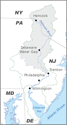
| The drainage area to SPW is shaded in gray. |
While intensive efforts were underway to clean up the tidal river to meet standards, monitoring demonstrated that the water quality in the non-tidal Delaware was already better than standards.
DRBC's Special Protection Waters (SPW) Program was initially adopted by the DRBC in 1992 and expanded in 1994 and 2008 (see below for program history).
Designed to prevent degradation in streams and rivers where existing water quality is better than the established water quality standards, the program states that there will be no measurable change in existing water quality of SPW except towards natural conditions.
Components of SPW Program
• Defining existing water quality (EWQ) at multiple control points within SPW, both on the Delaware River and at tributary confluences;
• Establishing stricter regulations for wastewater discharges;
• Permitting new or expanded pollutant loadings only if they do not measurably change the defined EWQ;
• Considering cumulative impacts of pollutant loadings, rather than just looking at them individually;
• Taking a watershed approach, looking at the designated waters as well as their drainage area; and
• Regulating both point and non-point source discharges.
What Part of the DRB is SPW?
Currently, the entire 197-mile non-tidal Delaware River from Hancock, N.Y. to Trenton, N.J. is considered Special Protection Waters, three-quarters of which is also included in the National Wild and Scenic Rivers System.
• Map of SPW Drainage Area (pdf 2.2 MB)
DRBC believes that its SPW regulations establish an anti-degradation policy on the longest stretch of any river in the nation.
Program Implementation
The SPW Program is managed through DRBC docket and state permitting programs (including the coordination of programs). Monitoring is performed to obtain data to assess changes to EWQ parameters.
Program Goal
To ensure that the level of water quality in SPW is not degrading over time. Simply, the goal is to keep the clean water clean.
Regulatory Review Threshold For Discharges in SPW
- Within the drainage area to Special Protection Waters (see map above), DRBC approval is required for new and expanding industrial and municipal wastewater treatment plants when the proposed facility is designed to discharge a daily average rate of 10,000 gallons a day or more during any consecutive 30-day period. This is a stricter threshold for review; in the rest of the DRB, the review threshold for discharges is 50,000 gallons a day or more during any consecutive 30-day period.
SPW Regulations Stipulate
- New or expanded discharges are only allowed if it can be demonstrated that they would cause no measurable change to existing water quality at established water quality control points.
- The evaluation of non-discharge, natural or load reduction alternatives, as well as their rejection due to technical and/or finanical infeasibility, is required.
Other SPW Requirements
- SPW regulations require that the treatment for wastewater discharges to SPW be Best Demonstrable Technology. Best Demonstrable Technology is defined for municipal facilities by 30-day average effluent criteria for seven parameters plus ultraviolet light disinfection. Equivalent criteria for industrial facilities are identified on a case-by-case basis.
- Projects located in the drainage area of Special Protection Waters that are subject to DRBC review must also have a Non-Point Source Pollution Control Plan (NPSPCP) that has been approved by the Commission. The NPSPCP describes the Best Management Practices that will be used at the project site and service area to control the increases in non-point source pollutant loadings resulting from the project.
- SPW regulations require monitoring to determine if measurable change is occurring at designated interstate and boundary control points where existing water quality has been defined. This monitoring program is conducted through an informal partnership between the National Park Service and the DRBC called the Scenic Rivers Monitoring Program (see next section).
- The data collected from SPW monitoring are also used in computer models that look at the cumulative impacts from multiple dischargers in a specific watershed. Models have been developed for priority tributaries, i.e. those that have a high number of existing discharges or are expected to have new growth and associated wastewater discharge needs. The models are used during DRBC project review to predict possible changes to water quality from a proposed project or project expansion and to establish discharge limits to prevent a measurable change to SPW. Current tributaries modeled include the Neversink River, Brodhead Creek, Lehigh River and Lower Delaware River (with tributaries).
 |
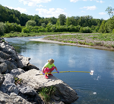
| DRBC staff collect a sample from the Brodhead Creek, a tributary to DRBC's SPW. Photo by DRBC. |
The SPW Monitoring Program (formerly known as the Scenic Rivers Monitoring Program) brings together the DRBC and the National Park Service (NPS) as partners to monitor and manage the water quality in SPW and in the Wild and Scenic river segments of the Upper Delaware Scenic and Recreational River (UPDE), Delaware Water Gap National Recreation Area (DEWA) and the Lower Delaware Scenic and Recreational River (LDEL). These river segments are considered to have exceptionally high scenic, recreational, ecological and/or water supply values.
Monitoring Leads
• NPS staff leads the monitoring programs in UPDE and DEWA
• DRBC staffs lead the LDEL program
Monitoring Parameters
• Close to 60 sites are sampled
• Includes mainstem and tributary sites; sites on tributaries are close to the confluence with the Delaware River
• Sites are monitored for nutrients, dissolved oxygen and other conventional pollutants, solids, bacteria, macroinvertebrates, periphyton (alga) and flow.
• Samples are analyzed by academic institutions or state laboratories
Monitoring Goals
• Determine that existing water quality is currently being maintained in SPW
• Allow for revised definitions of existing water quality (if needed)
New Assessment Period Started in 2023
Starting in May 2023, staff began a No Measurable Change Assessment for its SPW Program. Working with the NPS, 18 sites throughout the non-tidal river will be sampled twice a month, from May to September, 2023-2025.
Parameters include Alkalinity, Chloride, Hardness, Sulfate, TSS, TDS, Nirtate+Nitrite, Total Nitrogen, Ammonia, TKN, TP, Silica, Ca, Mg, Na, K, DO, turbidity, pH and water temperature.
During this time period, staff will also develop a plan to rotate monitoring sites every 3 years for recurring measurable change assessments, as well as examine defining EWQ at additional sites.
Learn More
- SPW Program Flyer (pdf 284 KB)
- DRBC SPW Monitoring Program Data Explorer (DRBC staff developed this interactive application that allows the user to explore water quality data collected since 2000.)
- Existing Water Quality Atlas of the Delaware River Special Protection Waters (September 2016)
- Lower Delaware River Special Protection Waters Assessment of Measurable Changes to Existing Water Quality, Round 1: Baseline EWQ (2000-2004) vs. Post-EWQ (2009-2011) (August 2016)
- Antidegradation Protection of Water Quality for the Delaware River Basin: Expansion of the Control Point Approach to Monitoring and Assessment (pdf 3.3 MB; presentation by DRBC staff at 2014 National Water Quality Monitoring Conference)
- Scenic Rivers Monitoring Program for the Non-Tidal Delaware River: Quality Assurance Project Plan 2013 (pdf 887 KB)
- Multi-Parameter Water Quality Meters: Standard Operating Procedures (2011):
- Conductivity (pdf 2 MB)
- Dissolved Oxygen (pdf 2.5 MB)
- pH (pdf 2 MB)
- Temperature (pdf 1.5 MB)
- Conductivity (pdf 2 MB)
- Scenic Rivers Monitoring Program for the Non-Tidal Delaware River: Quality Assurance Project Plan 2008-2009 (pdf 899 KB)
- DRBC/NPS Scenic Rivers Monitoring Program Fact Sheet (pdf 323 KB)
In 1992, DRBC adopted SPW regulations for point source (or "end-of-pipe") discharges, which were amended in 1994 to also include non-point source pollutant loadings carried by runoff. The regulations were enacted to protect existing high water quality in areas of the Delaware River Basin deemed "to have exceptionally high scenic, recreational, ecological and/or water supply values." They initially applied to a 121-mile stretch of the Delaware River from Hancock, N.Y. downstream to the Delaware Water Gap, and its drainage area. This includes the upper and middle sections of the non-tidal river federally designated as "Wild and Scenic" in 1978, as well as an eight-mile reach between Millrift and Milford, Pa., which is not federally designated.
- Map of 1992 SPW-classified area (pdf 313 KB)
In 2000, federal legislation was enacted adding key segments of the Lower Delaware and selected tributaries to the National Wild and Scenic Rivers System. This designation was followed in April 2001 with a petition from the Delaware Riverkeeper Network to classify the Lower Delaware, the 76-mile stretch of the non-tidal river between the Delaware Water Gap National Recreation Area and the head of tide at Trenton, N.J., as SPW. Extensive data were collected from 2000 through 2004 which confirmed that existing water quality in this stretch of river exceeded most state and federal standards.
- Lower Delaware River Eligibility Determination for DRBC Declaration of Special Protection Waters (pdf 1.25 MB; August 2004)
- Lower Delaware Monitoring Program: 2000-2003 Results and Water Quality Management Recommendations (pdf 3.3 MB; August 2004)
- Lower Delaware Water Quality Monitoring Program Quality Assurance Project Plan (pdf 1.9 MB; July 2003)
- Lower Delaware Monitoring Data:
- 2000-2004 Base Data (xls 2.8 MB)
- Additional Supporting Water Quality Data (xls 3.5 MB)
- 2000-2004 Base Data (xls 2.8 MB)
- Map Depicting Lower Delaware Scenic River Segments, Dischargers, and Monitoring Locations (pdf 1.9 MB)
In 2005, based in part upon these findings, the DRBC temporarily classified the Lower Delaware as SPW. This temporary designation made the Lower Delaware subject to all SPW regulations except those that required the use of numeric values for existing water quality. Temporary designation provided a measure of protection while allowing time for the public rulemaking process to take place and for implementation details to be thoroughly considered.
- Resolution 2005-2 (pdf 20 KB; temporarily classifies the Lower Delaware as SPW)
- Map of the temporarily-designated-as-SPW Lower Delaware River (pdf 501 KB)
The commission extended the temporary designation on four different occasions:
- Resolution 2005-15 (pdf 13 KB; extended through September 30, 2006)
- Resolution 2006-22 (pdf 12 KB; extended through September 30, 2007)
- Resolution 2007-13 (pdf 10 KB; extended through May 15, 2008)
- Resolution 2008-3 (pdf 12 KB; extended through July 31, 2008)
On July 16, 2008, by unanimous vote, the DRBC permanently designated the Lower Delaware as Significant Resource Waters, one of the two available SPW classifications.
- Resolution 2008-9 (pdf 711 KB; permanently designates the Lower Delaware as Significant Resource Waters)
- July 17, 2008 News Release Announcing the Permanent Designation
- Lower Delaware SPW Classification Response to Comments Document (pdf 1.1 MB)
- SPW Final Rule (pdf 60 KB; as appears in the September 26, 2008 Federal Register)
Copyright © Delaware River Basin Commission,
P.O. Box 7360, West Trenton, NJ 08628-0360
Phone (609)883-9500; Fax (609)883-9522
Thanks to NJ for hosting the DRBC website