The Pinelands Comprehensive Management Plan (CMP) was adopted in 1980 following a planning process that began in 1979. What sets the CMP apart from most other land-use regulation and planning programs is that it was based on an ecosystem approach to protecting the natural resources of the New Jersey Pinelands. A major element of the CMP is a land-use-management program that directs development away from areas considered ecologically critical to areas deemed less critical.
Implementation of the CMP over the past three decades has involved more local and site-specific approaches. At times, single issues have overshadowed the broader, multifaceted goal of ensuring the long-term preservation of a unique ecosystem. The purpose of this ecological-integrity assessment is to focus on the big picture again by evaluating the current ecological status of the entire 938,173-acre (379,827-ha) Pinelands Area and the ecosystem that it represents. The concept of ecological integrity as it was applied to the Pinelands Area, a description of the approach used to characterize ecological integrity, and the results of the assessment are presented in Zampella et al. 2008 (26.2 MB).
The concept of ecological integrity as it was applied to the Pinelands Area, a description of the approach used to characterize ecological integrity, and the results of the assessment are presented in a report, titled "An Ecological-integrity Assessment of the New Jersey Pinelands: A Comprehensive Assessment of the Landscape and Aquatic and Wetland Systems of the Region."
Download the full report (Click here) (26.2 MB)
Integrity layers Download (11.9 MB) This data download includes the landscape-, aquatic-, wetland-drainage-, and ecological-integrity geospatial layers and supporting metadata. Below is a brief explanation of the four integrity layers. See the metadata for each layer for additional details.
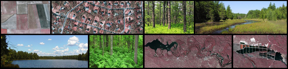
New Jersey Pinelands Commission Landscape-integrity Layer Metadata: The landscape-integrity layer was created as part of the New Jersey Pinelands Commission ecological-integrity assessment (Zampella et al. 2008). Landscape integrity was defined as the percentage of Pinelands habitat in a window surrounding each 10×10-m Pinelands-habitat cell. Pinelands habitat, as defined in Zampella et al. (2008), was based on 2002 land-use/land-cover data (NJDEP 2007) and included upland forests, water, and wetlands, with the exception of managed wetlands and wetland agriculture. This raster layer contains non-habitat cells and the landscape-integrity scores for habitat cells in the Pinelands Area.
New Jersey Pinelands Commission Aquatic-integrity Layer Metadata: The aquatic-integrity layer was created as part of the New Jersey Pinelands Commission ecological-integrity assessment (Zampella et al. 2008). Aquatic integrity, which was defined as the percentage of land in a watershed that is neither developed land nor upland agriculture based on 2002 land-use/land-cover data (NJDEP 2007) and as defined in Zampella et al. (2008), was determined for each drainage unit. The term drainage unit refers to a section of the watershed. This raster layer contains the aquatic-integrity scores for each drainage unit in the Pinelands Area.
New Jersey Pinelands Commission Wetland-drainage integrity Layer Metadata: The wetland-drainage-integrity layer was created as part of the New Jersey Pinelands Commission ecological-integrity assessment (Zampella et al. 2008). Wetland-drainage integrity was defined as the percentage of a wetland-drainage unit that was neither developed land nor upland agriculture based on 2002 land-use/land-cover data (NJDEP 2007) and as defined in Zampella et al. (2008). The term drainage unit refers to a section of a watershed. Drainage units were split along streams to create wetland-drainage units. Additional wetland-drainage units were delineated for the upper limit of mapped streams. This raster layer contains the wetland-drainage integrity scores for each wetland-drainage unit in the Pinelands Area.
New Jersey Pinelands Commission Ecological-integrity Layer Metadata: The ecological-integrity layer was created as part of the New Jersey Pinelands Commission ecological-integrity assessment (Zampella et al. 2008). An ecological-integrity score was determined for every 10×10-m Pinelands-habitat cell in the Pinelands Area. Each ecological-integrity score represents an average of the landscape-, aquatic-, and wetland-drainage-integrity scores. This raster layer contains non-habitat cells and the ecological-integrity scores for habitat cells in the Pinelands Area.
New Jersey Pinelands Commission Wetland-integrity Layer Metadata: The wetland-integrity layer was created as part of the New Jersey Pinelands Commission ecological-integrity assessment (Zampella et al. 2008). A wetland-integrity score was determined for every 10×10-m wetland-habitat cell in the Pinelands Area. Wetlands, as defined in Zampella et al. (2008), were based on 2002 land-use/land-cover data (NJDEP 2007) with the exception of managed wetlands and wetland agriculture. A single score was assigned to discrete wetland units. This raster layer contains wetland-integrity scores for wetland-habitat cells in the Pinelands Area.
Watershed Layers Download (55.2 MB) This data download includes the watershed, drainage-unit, and wetland-drainage-unit geospatial layers and supporting metadata. Below is a brief explanation of the three layers. See the metadata for each layer for additional details.
New Jersey Pinelands Commission Watershed Layer Metadata: The watershed layer was created as part of the New Jersey Pinelands Commission ecological-integrity assessment (Zampella et al. 2008). Watersheds were created using NJDEP (1996) stream data, a digital-elevation model (NJDEP 2002), and Arc Hydro (ESRI 2007). This shapefile contains the watersheds for the Pinelands Area.
New Jersey Pinelands Commission Drainage-unit Layer Metadata: The drainage-unit layer was created as part of the New Jersey Pinelands Commission ecological-integrity assessment (Zampella et al. 2008). Drainage units were created using NJDEP (1996) stream data, a digital-elevation model (NJDEP 2002), and Arc Hydro (ESRI 2007). The term drainage unit refers to a section of a watershed. This shapefile contains the drainage units for the Pinelands Area.
New Jersey Pinelands Commission Wetland-drainage-unit Layer Metadata: The wetland-drainage-unit layer was created as part of the New Jersey Pinelands Commission ecological-integrity assessment (Zampella et al. 2008). Drainage units were created using NJDEP (1996) stream data, a digital-elevation model (NJDEP 2002), and Arc Hydro (ESRI 2007). The term drainage unit refers to a section of a watershed. Drainage units were split along streams to create wetland-drainage units. Additional wetland-drainage units were delineated for the upper limit of mapped streams. This shapefile contains the wetland-drainage units for the Pinelands Area.
References:
ESRI. 2007. Arc Hydro for ArcGIS 9 Version 1.2 Beta. Environmental Systems Research Institute, Redlands, California, USA.
NJDEP. 1996. New Jersey geographic information system CD-ROM, Series 1, Volumes 1-4. New Jersey Department of Environmental Protection, Office of Information Resource Management, Bureau of Geographic Information Systems, Trenton, New Jersey, USA.
NJDEP. 2002. NJDEP 10-meter digital elevation grid, watershed management areas 13-20. New Jersey Department of Environmental Protection, Office of Information Resource Management, Bureau of Geographic Information Systems, Trenton, New Jersey, USA.
NJDEP. 2007. NJDEP land use/land cover update, watershed management areas 13-20. New Jersey Department of Environmental Protection, Office of Information Resource Management, Bureau of Geographic Information Systems, Trenton, New Jersey, USA.
Zampella, R. A., N. A. Procopio, M. U. Du Brul, J. F. Bunnell. 2008. An ecological-integrity assessment of the New Jersey Pinelands: A comprehensive assessment of the landscape and aquatic and wetlands systems of the region. Pinelands Commission, New Lisbon, NJ, USA.


Pinelands Commission
15 Springfield Road
New Lisbon, NJ 08064
609-894-7300