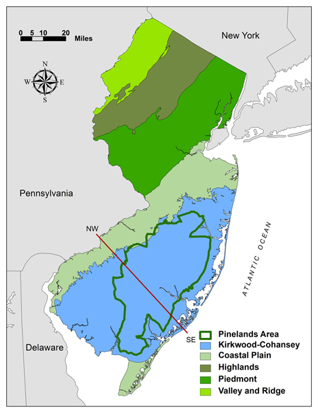
 New Jersey Public Law 2001, Chapter 165 directed the Pinelands Commission to assess and prepare a report on the key hydrologic and ecological information needed to determine how the current and future water-supply needs within the Pinelands area may be met while protecting the Kirkwood-Cohansey aquifer system and avoiding any adverse ecological impact on the Pinelands area. The legislation appropriated $5,500,000 from the Water Supply Fund for the preparation of the assessment by the Pinelands Commission, which was to be implemented in cooperation with the New Jersey Department of Environmental Protection, Rutgers University, the U. S. Fish and Wildlife Service, and the U.S. Geological Survey.
To the right is a map showing four physiographic provinces in New Jersey, the Kirkwood-Cohansey aquifer system, and the Pinelands Area boundary and below is a generalized cross section of the Coastal Plain in southern New Jersey from the red line in the map.
Scientists from the cooperating agencies and institutions completed a work plan for the Kirkwood Cohansey Project that underwent peer review. The work plan, which was approved by the Commission in October 2003 following a public hearing, addressed two major research questions. First, what are the probable hydrologic effects of groundwater diversions from the Kirkwood-Cohansey aquifer on stream flows and wetland water levels? Second, what are the probable ecological effects of induced stream-flow and groundwater-level changes on aquatic and wetland communities?
Twelve separate studies were completed as part of the Kirkwood-Cohansey Project. The results of some of the studies can be used to estimate the potential impacts of groundwater withdrawals on aquatic and wetland resources in the Pinelands, which can help provide the foundation for developing improved water-supply policies for the Kirkwood-Cohansey aquifer. Below is a brief summary of each study and links to the published reports and/or journal articles.
Hydrologic-framework Study
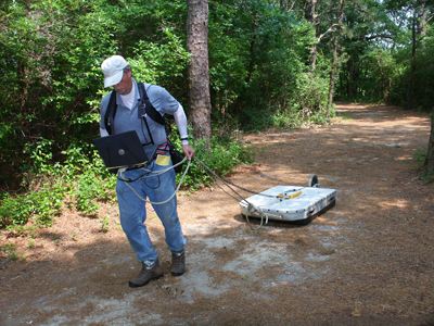
U.S. Geological Survey scientists prepared a hydrogeologic-framework model for the three selected study watersheds: McDonalds Branch, Albertson Brook, and Morses Mill Stream. Existing hydrogeologic data from the three watersheds was assembled, and additional borehole and surface geophysical surveys and measurements of the hydraulic properties of the watersheds were completed. This information was used to partition the Kirkwood-Cohansey aquifer system into seven separate layers each designated as either an aquifer layer or leaky confining layer. All seven layers are situated on top of a basal clay confining layer that separates the Kirkwood-Cohansey aquifer system from deeper aquifers. The hydrogeologic-framework models created in this study provided the structural foundation to build predictive groundwater-flow models for each of the three study watersheds. See the link below for more details.
Walker, R. L., P. A. Reilly, and K. M. Watson. 2008. Hydrogeologic framework in three drainage basins in the New Jersey Pinelands, 2004-06: U.S. Geological Survey Scientific Investigations Report 2008-5061, 147 p. http://pubs.usgs.gov/sir/2008/5061/
Hydrologic-assessment Study
U.S. Geological Survey scientists completed a hydrologic assessment of the McDonalds Branch, Albertson Brook, and Morses Mill Stream study areas. Existing and new groundwater and surface-water data were compiled, a water-table map was created, and a water budget was determined for the three watersheds. The interaction of the Kirkwood-Cohansey aquifer system with wetlands and surface water was characterized for the three watersheds. Information from the hydrologic assessment was combined with the hydrogeologic-framework models (see Hydrologic-framework study above) and used to develop and calibrate predictive groundwater-flow models (see Hydrologic-modeling study below) for the McDonalds Branch, Albertson Brook, and Morses Mill Stream watersheds. See the link below for more details.
Walker, R. L., R. S. Nicholson, and D. A. Storck. 2011. Hydrologic Assessment of Three Drainage Basins in the Pinelands of Southern New Jersey, 2004-06. U.S. Geological Survey Scientific Investigations Report 2011-5056, 145 p. http://pubs.usgs.gov/sir/2011/5056/
Evapotranspiration Study
Evapotranspitation (ET) represents the combined movement of water evaporated from surfaces and transpired by plants from the ground to the atmosphere. U.S. Geological Survey scientists collected ET data using a tower installed in a McDonalds Branch wetland site and obtained ET data from two upland forest towers monitored by U.S. Department of Agriculture Forest Service personnel as part of another study. Using these upland and wetland ET data, total ET was estimated for the McDonalds Branch, Alberston Brook, and Morses Mill Stream watersheds. ET estimates were then used in the construction of surface-water budgets for each of the three watersheds, and as initial ET estimates in the development of groundwater-flow models (see Hydrologic Modeling study below). See the link below for more details.
Sumner, D. M., R. S. Nicholson, and K. L. Clark. 2012. Measurement and simulation of evapotranspiration at a wetland site in the New Jersey Pinelands. U.S. Geological Survey Scientific Investigations Report 2012-5118, 30 p. http://pubs.usgs.gov/sir/2012/5118/
Hydrologic-modeling study
U.S. Geological Survey scientists utilized the structural layering of the aquifer system revealed through the Hydrologic-framework study, groundwater level and streamflow information obtained during the Hydrologic-assessment study, evapotranspiration data from the ET study, and aquifer tests completed in each watershed to develop three-dimensional groundwater-flow models for the McDonalds Branch, Albertson Brook, and Morses Mill Stream watersheds. Multiple groundwater-withdrawal scenarios were imposed on the models and the stream flow and groundwater responses were measured. Several approaches were then developed to apply the results of the hydrologic modeling to other Pinelands watersheds so the potential local and regional impacts of proposed wells on stream flow and groundwater levels could be estimated anywhere in the Pinelands using limited field and GIS data. See the link below for more details.
Charles, E. G. and R. S. Nicholson. 2012. Simulation of groundwater flow and hydrologic effects of groundwater withdrawals from the Kirkwood-Cohansey aquifer system in the Pinelands of southern New Jersey. U.S. Geological Survey Scientific Investigations Report 2012-5122, 219 p. http://pubs.usgs.gov/sir/2012/5122/
Stream Fish and Invertebrate Study
![]() U.S. Geological Survey scientists sampled stream fish and aquatic invertebrates and developed statistical models to predict potential changes in fish- and invertebrate-assemblage characteristics that may result from reductions in streamflow due to groundwater pumping. Based on the models developed, the specific response to reduced streamflow may be an increase or a decrease in the particular fish or invertebrate metric. Because of the strong relationship between streamflow and watershed size, the fish and invertebrate models can be applied throughout the Pinelands using watershed area as a surrogate measure of streamflow. See the links below for more details.
U.S. Geological Survey scientists sampled stream fish and aquatic invertebrates and developed statistical models to predict potential changes in fish- and invertebrate-assemblage characteristics that may result from reductions in streamflow due to groundwater pumping. Based on the models developed, the specific response to reduced streamflow may be an increase or a decrease in the particular fish or invertebrate metric. Because of the strong relationship between streamflow and watershed size, the fish and invertebrate models can be applied throughout the Pinelands using watershed area as a surrogate measure of streamflow. See the links below for more details.
Kennen, J. G. and M. L. Riskin. 2010. Evaluating effects of potential changes in streamflow regime on fish and aquatic-invertebrate assemblages in the New Jersey Pinelands: U.S. Geological Survey Scientific Investigations Report 2010-5079, 34 p. http://pubs.usgs.gov/sir/2010/5079/
Kennen, J. G., M. L. Riskin, E. G. Charles. 2014. Effects of streamflow reductions on aquatic macroivertebrates: Linking groundwater withdrawals and assemblage response in southern New Jersey streams, USA. Hydrological Sciences Journal 59: 1-17. http://www.tandfonline.com/doi/abs/10.1080/02626667.2013.877139#.VJsd6F4AAA
Nitrogen Laboratory and Field Study
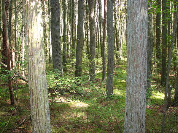 The lowering of groundwater levels from groundwater pumping may reduce soil moisture and potentially lead to the conversion of soil organic nitrogen to other forms of nitrogen that are more mobile. Rutgers University scientists conducted laboratory and field studies in wetland-forest soils to assess whether unsaturated soil conditions from lowered water-table levels could release pulses of excess nitrogen into the groundwater. Pitch pine lowland and pine-hardwood lowland forests, representing mineral-hydric soils, and Atlantic white cedar swamps, representing muck soils, were selected for the studies. See the links below for more details.
Yu, S. and J. G. Ehrenfeld. 2009. The effects of changes in soil moisture on nitrogen cycling in acid wetland types of the New Jersey Pinelands (USA). Soil Biology and Biochemistry 41:2394-2405. http://www.crssa.rutgers.edu/projects/kc/
Ehrenfeld, J.G. and S. Yu. 2012. Patterns of nitrogen mineralization in wetlands of the New Jersey Pinelands along a shallow water table gradient. American Midland Naturalist 167:322-335. http://www.bioone.org/doi/abs/10.1674/0003-0031-167.2.322?journalCode=amid
Ehrenfeld, J. G., and S. Yu. 2010. Nitrogen dynamics study final report. Part II. Dynamics of nitrogen under field conditions. Rutgers University, New Brunswick, New Jersey, USA. http://www.crssa.rutgers.edu/projects/kc/
Stream-habitat Study
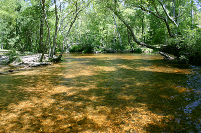
Using data from 14 stream sites, Pinelands Commission scientists simulated streamflow reductions of 5, 10, 20 and 30 percent of average annual streamflow and seven-day low-flow. The percentage reduction to average stream width, depth, area, volume, and velocity were estimated. Models derived from a separate fish and invertebrate study (see Stream Fish and Invertebrate study above) were used to estimate fish and invertebrate responses based on simulated reductions in average annual streamflow. See the links below for more details.
Procopio, N. A. 2012. The effect of streamflow reductions on aquatic habitat availability and fish and macroinvertebrate assemblages in coastal plain streams. Ecohydrology 5:306-315. http://onlinelibrary.wiley.com/doi/10.1002/eco.220/abstract
Procopio, N. A. 2010. The effect of streamflow reductions on aquatic habitat availability and fish and macroinvertebrate assemblages in coastal plain streams. Pinelands Commission, New Lisbon, New Jersey, USA. http://www.state.nj.us/pinelands/science/pub/KC%20Habitat%20assessment%20Final%20Report.pdf
Swamp pink Study
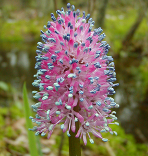 Pinelands Commission and U.S. Fish and Wildlife scientists studied the potential impact of groundwater withdrawals on swamp pink (Helonius bullata), which is a federally endangered perennial herbaceous plant. Using two swamp pink colonies located along small streams in the Pinelands, scientists characterized site hydrology, substrate, topography, tree-canopy cover, and hydrologic regimes associated with 958 swamp pink clusters. The potential impact of simulated water-level reductions on the species and its habitat were assessed. See the links below for more details.
Laidig, K. J., R. A. Zampella, and C. Popolizio. 2009. Hydrologic regimes associated with Helonias bullata L. (swamp pink) and the potential impact of simulated water-level reductions. Journal of the Torrey Botanical Society 136:221-232. http://www.state.nj.us/pinelands/science/pub/HeloniasBullata.pdf
Laidig, K. J., R. A. Zampella, and C. Popolizio. 2010. Hydrologic regimes associated with Helonias bullata L. (swamp pink) and the potential impact of simulated water-level reductions. Pinelands Commission, New Lisbon, New Jersey, USA. http://www.state.nj.us/pinelands/science/pub/KC%20Helonias%20Final%20Report.pdf
Pond-vegetation Study
Pinelands Commission scientists studied the potential impact of simulated water-level reductions on intermittent-pond vegetation. Pond hydrology was monitored and pond bathymetry (i.e., pond basin shape) and vegetation patches were mapped in 15 Pinelands ponds. Five dominant vegetation-patch types occurred at the ponds, including aquatic-herbaceous, wetland-herbaceous, Walter’s sedge, leatherleaf, and high-bush blueberry. Ground water withdrawals were simulated by reducing pond-water depth and the resulting changes in vegetation were estimated. See the links below for more details.
Laidig, K. J. 2012. Simulating the effect of groundwater withdrawals on intermittent-pond vegetation communities. Ecohydrology 5:841-852. http://dx.doi.org/10.1002/eco.277
Laidig, K. J. 2010. The potential impact of simulated water-level reductions on intermittent-pond vegetation. Pinelands Commission, New Lisbon, New Jersey, USA. http://www.state.nj.us/pinelands/science/pub/KC%20Pond%20Veg%20Final%20Report.pdf
Frog-development Study
Pinelands Commission scientists studied the potential impact of simulated groundwater withdrawals on the egg deposition, larval development, and metamorphosis of pond-breeding frogs. Pond hydrology and egg deposition, larval development, and metamorphosis for three frog species were tracked over a two-year period in three intermittent ponds. The three frog species studied were the spring peeper, the southern leopard frog, and the state threatened Pine Barrens treefrog. Simulated groundwater withdrawals were imposed on each pond and the potential impacts of withdrawals were estimated for the various life stages of the frogs. See the links below for more details
Bunnell, J. F. and J. L. Ciraolo. 2010. The potential impact of simulated ground-water withdrawals on the oviposition, larval development, and metamorphosis of pond-breeding frogs. Wetlands Ecology and Management 18:495-509. http://dx.doi.org/10.1007/s11273-010-9182-2
Bunnell, J. F. and J. L. Ciraolo. 2010. The potential impact of simulated groundwater withdrawals on the oviposition, larval development, and metamorphosis of pond-breeding frogs. Pinelands Commission, New Lisbon, New Jersey, USA. http://www.state.nj.us/pinelands/science/pub/KC%20Anuran%20Final%20Report.pdf
Wetland-forest Study
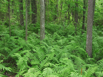 Pinelands Commission scientists developed vegetation models to predict the potential effect of groundwater withdrawals on forested wetlands. Woody and herbaceous vegetation, soil characteristics, and groundwater levels were characterized in 201 plots located in forests classified as upland pine oak, pitch pine lowland, pine-hardwood lowland, hardwood swamp, or cedar swamp. Vegetation models were developed that, when linked to groundwater-hydrology models (see Hydrologic-modeling study above) and landscape-level applications (see Landscape-application Study below), can be used to predict the potential effect of groundwater-level declines on the distribution of wetland-forest communities, individual wetland species, and wetland-indicator groups. See the links below for more details.
Laidig, K. J., R. A. Zampella, A. M. Brown, and N. A. Procopio. 2010. Development of vegetation models to predict the potential effect of groundwater withdrawals on forested wetlands. Wetlands 30:489-500. http://dx.doi.org/10.1007/s13157-010-0063-5
Laidig, K. J., R. A. Zampella, A. M. Brown, and N. A. Procopio. 2010. Development of vegetation models to predict the potential effect of groundwater withdrawals on forested wetlands. Pinelands Commission, New Lisbon, New Jersey, USA. http://www.state.nj.us/pinelands/science/pub/KC%20Palustrine%20Final%20Report.pdf
Landscape-application Study
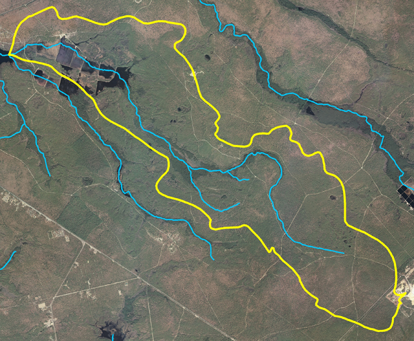 Rutgers University scientists used a geographic information system to integrate and apply hydrology-vegetation models from the Wetland-forest study and groundwater-pumping scenarios from the Hydrologic-modeling study across the three study watersheds: McDonalds Branch, Albertson Brook, and Morses Mill Stream. Scientists simulated the potential landscape-level impact of various groundwater-withdrawal scenarios on four forest types and wetland-indicator species in each watershed. See the links below for more details.
Zhang, Y., Z. Miao, J. Bognar, and R. G. Lathrop Jr. 2011. Landscape scale modeling of the potential effect of groundwater-level declines on forested wetlands in the New Jersey Pinelands. Wetlands 31:1131-1142. http://link.springer.com/article/10.1007/s13157-011-0223-2
Lathrop, R. G., Y. Zhang, Z. Maio, and J. Bognar. 2010. Landscape level modeling of the potential effect of groundwater-level declines on forested wetlands in the New Jersey Pinelands. Rutgers University, New Brunswick, New Jersey, USA. http://www.crssa.rutgers.edu/projects/kc/


