| | Construction Updates |
|
Route 70/73 Marlton
Circle Elimination Project
Overview |
|
Frequently Asked
Questions |
|
| Roadway Improvements |
|
| Enhancements |
|
| Project Maps |
|
| Community Outreach |
|
| Stages
and Schedule |
|
| Cameras |
|
| Photos |
|
Archived Photos
2011 |
| 2010 |
| December
2, 2010 |
| November
8, 2010 |
| October
15, 2010 |
| September
8, 2010 |
| August
4, 2010 |
| July
13 , 2010 |
| May
5, 2010 |
| April
9, 2010 |
| March
16, 2010 |
| February
5, 2010 |
| January
4, 2010 |
| 2009 |
|
| Useful
Links |
|
|


Archived
Photos
May
5,
2010
(click on thumbnail photos to enlarge in bottom window)
|
|
|
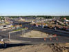
This
view
is
of
Route
70/73
Marlton
Circle
Elimination
Project
looking
northwest. |
|
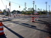
This
view
is
looking
towards
Main
Street
from
the
Ramp
B spur
at
the
temporary
traffic
signal
at
the
intersection
of
Main
Street/Ramp
D/Ramp
B spur.
|
|
|
|
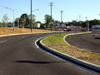
This
view
is
of
Ramp
D
heading
towards
Route
70.
The
Marlton
Greene
parking
lot
is
on
the
right. |
|
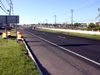
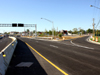
Looking
south,
this
view
is
of
the
temporary
crossover
of
Route
73
northbound. |
| |
Looking
south,
this
view
is
of
the
temporary
Route
73
southbound
Ramp
K/Ramp
E . |
|

|
|