Long-term Environmental-monitoring Program

In the early 1990's, the Pinelands Commission initiated a long-term environmental-monitoring program with the ultimate goal of evaluating the ecological consequences of the Comprehensive Management Plan for the Pinelands National Reserve. The main objectives of this program are to characterize the effect of existing land-use patterns on aquatic and wetland resources and to monitor long-term changes in these resources. Individual components of the program include watershed assessments, Pinelands-wide water-quality monitoring, forest-plot and intermittent-pond water-level monitoring, and annual-anuran (frog and toad) surveys.
Watershed Assessments
 As part of the environmental-monitoring program, Commission scientists sampled water quality and surveyed vegetation, fish, and anuran (frog and toad) communities throughout four major Pinelands watersheds: the Mullica River, Rancocas Creek, Great Egg Harbor River, and Barnegat Bay watersheds. A brief summary of the results of the watershed assessments, individual watershed reports, and associated Pinelands-wide geospatial-data layers are available at Watershed Studies.
Staff scientists completed a second round of water-quality and biological surveys in each of the four major watersheds. The Mullica River Watershed was surveyed in 2007 and 2008, the Rancocas Creek Watershed in 2009, the Great Egg Harbor River Watershed in 2010, and the Barnegat Bay Watershed in 2011. Similar to the initial watershed assessments, the second round of surveys included water-quality monitoring (pH and specific conductance) and vegetation, fish, and anuran surveys in streams and impoundments throughout the region. A comprehensive report that describes the status of all four watersheds will be compiled after the data have been analyzed.
Click here to be directed to an interactive map of the sites.
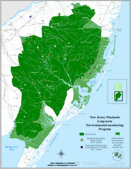
Map of water quality and vegetation, fish, and anuran (frog and toad) community long-term environmental-monitoring sites throughout four major Pinelands watersheds. Click the map for larger view.
Pinelands-wide Water-quality Monitoring
 In 2005, a network of 47 stream sites was selected from the entire pool of sites monitored during the initial four watershed-assessment surveys. Specific conductance and pH are monitored at each site in the network. The 47 sites are distributed throughout the Pinelands and represent a range of pH and specific conductance values. One of the goals of this network of sites is to monitor long-term trends in pH and specific conductance throughout the region.
Click here to be directed to an interactive map of the sites.
Map of 47 Pinelands-wide water-quality monitoring sites and five additional stream sites in the four major Pinelands watersheds. Click the map for larger view.
Water-level Monitoring
 Water levels are monitored in 35 forest plots and 37 intermittent coastal-plain ponds. The 35 forest plots represent an upland-to-wetland gradient and are characterized as upland pine-oak, pitch pine lowland, pine-hardwood lowland, hardwood swamp, or cedar swamp. Water levels have been measured monthly in 30 of the forest plots since 2004 and in five of the forest plots since 1987. Water levels are also measured in 37 coastal-plain ponds. Fourteen ponds have been monitored since 1996, 15 ponds since 2004, five ponds since 2010, and three ponds since 2012. Battery operated continuous pond-water-level recorders have been installed in seven of the 37 ponds.
 Click here to view water-level data for the 34 intermittent coastal-plain ponds.
 Click here to view water-level data for the 35 forest plots.
Click here to be directed to an interactive map of the sites.
Map of 35 forest plot and 34 intermittent coastal-plain pond water-level monitoring sites throughout the Pinelands. Click the map for larger view.
Annual Anuran-survey Ponds

Amphibians have been declining globally since at least the late 1950's and early 1960's. Possible reasons for amphibian declines vary and include ultraviolet radiation, aquatic pollution, habitat loss, landscape fragmentation, disease and infections, and the introduction of non-native amphibians and predatory fish. Because of the wide-spread nature of these declines, Commission scientists established 20 long-term monitoring stations to assess temporal changes in the status of anurans. Annual anuran-vocalization surveys have been conducted at these 20 sites since 1996. The 20 ponds were selected as long-term monitoring stations because they are located on the western side of the Mullica River Watershed along the interface between forest land and developed and farmed landscapes. Since 1996, eleven frog species and one toad species have been heard calling from the 20 ponds. Eighteen ponds serve as breeding habitat for the state-threatened Pine Barrens treefrog. Fourteen of the ponds have been intensively surveyed for adult and larval frogs and toads during a previous Commission study (Bunnell and Zampella 1999) and the vegetation present at 13 of these ponds has been described in detail (Zampella and Laidig 2003). Frog-larval development and metamorphosis was monitored at three of the ponds as part of the Kirkwood-Cohansey Project.


Pinelands Commission
15 Springfield Road
New Lisbon, NJ 08064
609-894-7300